Newfoundland: Rain, bump in temperatures heighten flood threat

Snowmelt and localized flooding is possible as temperatures climb above zero and rain falls across Newfoundland on Monday.
Rainfall warnings and special weather statements remain in place for parts of Newfoundland for Monday as rain and above seasonal temperatures heighten the risk for localized flooding for the region. Some areas still have over one metre of snow on the ground and the mild conditions, combined with the period of heavy rain could create rapid snowmelt and localized flooding. Details and timing, below.
Winter versus your phone: Here's why your phone shuts down in the cold
WEATHER HIGHLIGHTS
Localized flooding possible in heavy rain/accelerated snowmelt for Newfoundland
Temperature plunge through week will make for bitterly cold wind chills
Stay up-to-date on the ALERTS in your area
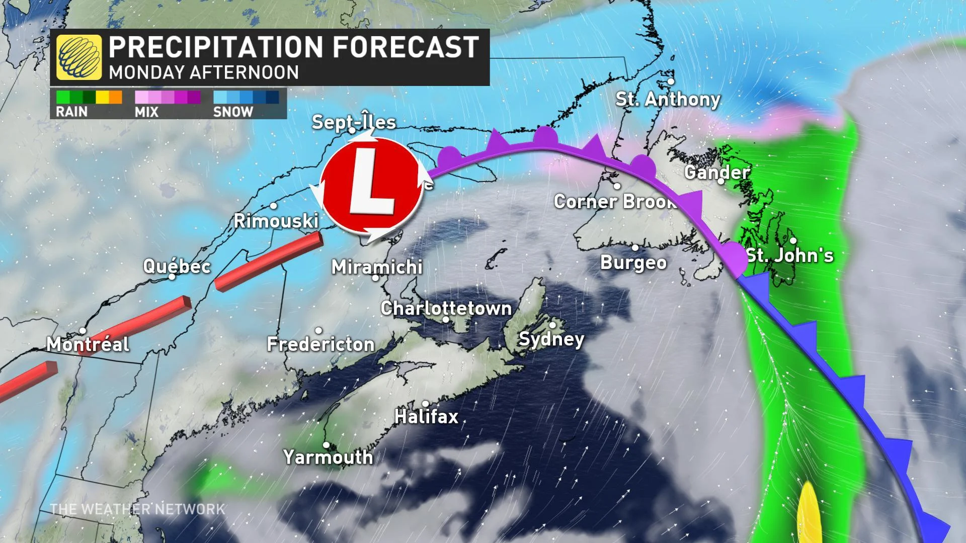
MONDAY: RAIN, SNOW MOVE INTO NEWFOUNDLAND
Rain and snow will track through Newfoundland on Monday and Weather Network meteorologist Tyler Hamilton warns that there is a flood risk due to the significant amount of snow on the ground. The combination of temperatures climbing a few degrees above zero, plus over one metre of snow in some areas means that snowmelt and water runoff could create pooling water and localized floods.
Between 10 to 15 mm of rain is targeting the Avalon through the afternoon, with heavier amounts up to 30 mm possible for the Connaigre and Burin Peninsulas. Officials have warned residents to ensure that drains are cleared of snow to help prevent any waterlogged roads and homes.
Snow will persist over the northwest and all told, up to 20 cm is expected for the hardest-hit regions before the snow tapers to flurries on Monday night.
According to St. John's mayor, Danny Breen, city staff are still working around the clock to clean up any ongoing issues on city streets.
Despite restrictions being lifted following the histoic blizzard, life is still far from "normal" across the hardest hit parts of the island. A parking ban is still in effect in St. John's and some elementary schools also remain closed. Metrobus is back up and running on Monday, after a full week off the roads.
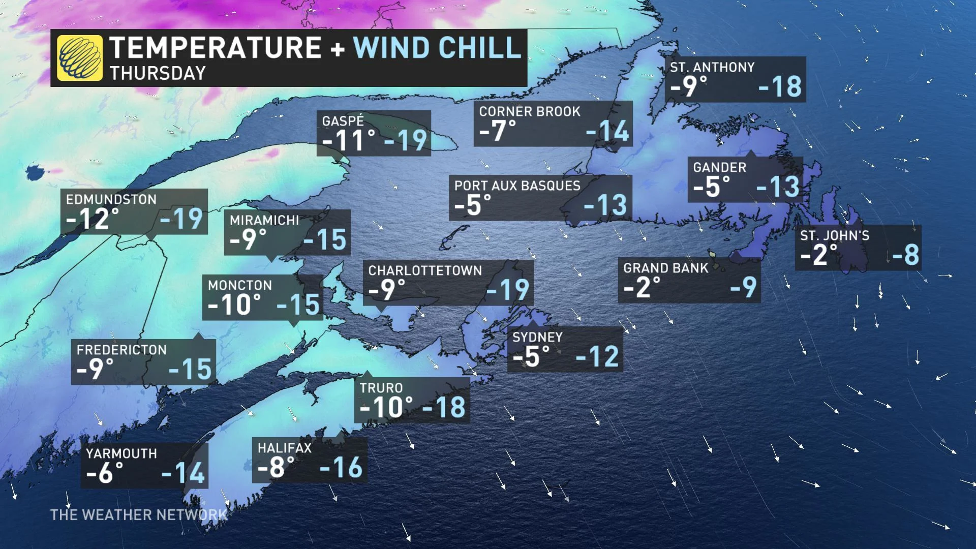
LOOK AHEAD: FROSTY, BLUSTERY WEEK IN STORE
A disturbance trailing through the region through Tuesday will bring widespread light flurries across the Maritimes and Newfoundland as temperatures start to take a downward turn into the week.
By midweek, high pressure building over eastern Canada will mean mainly sunny skies, but at the cost of some sharply colder temperatures as a shot of arctic air drops in from Nunavut and northern Quebec. Afternoon highs will struggle to top -10ºC for many by Thursday, with wind chill values of -15 or lower for much of the region.
ANOTHER WEEKEND STORM BREWING?
Forecasters are also keeping a close eye on the potential for a strong storm that could impact the region on Sunday and into early next week.
"It is still too early to have confidence in the track and impacts of this storm, but definitely a system to closely watch with the potential to exceed the criteria for a weather bomb," says Weather Network meteorologist Dr. Doug Gillham.
According to Gillham, the very preliminary thoughts are that rain will dominate for central and eastern Newfoundland, while the wintry side of the storm will be felt across the Maritimes.
Stay with us here at The Weather Network for your latest forecast updates.