
Atlantic: Thousands without power after strong 'bomb cyclone' hits

Heavy rain and near hurricane-force wind gusts are taking aim at the already vulnerable areas of the Maritimes following Dorian last month.
Widespread warnings cover much of the Maritimes as the first weather bomb of the season dumps heavy rain and damaging winds. Although much weaker than the strength of post-tropical storm Dorian, this storm targets areas that were already significantly impacted last month. More on the timing of this potent system and the emergency preparations currently underway, below.
Visit our Complete Guide to Fall 2019 for an in-depth look at the Fall Forecast, tips to plan for it and a sneak peek at the winter ahead
WEATHER HIGHLIGHTS:
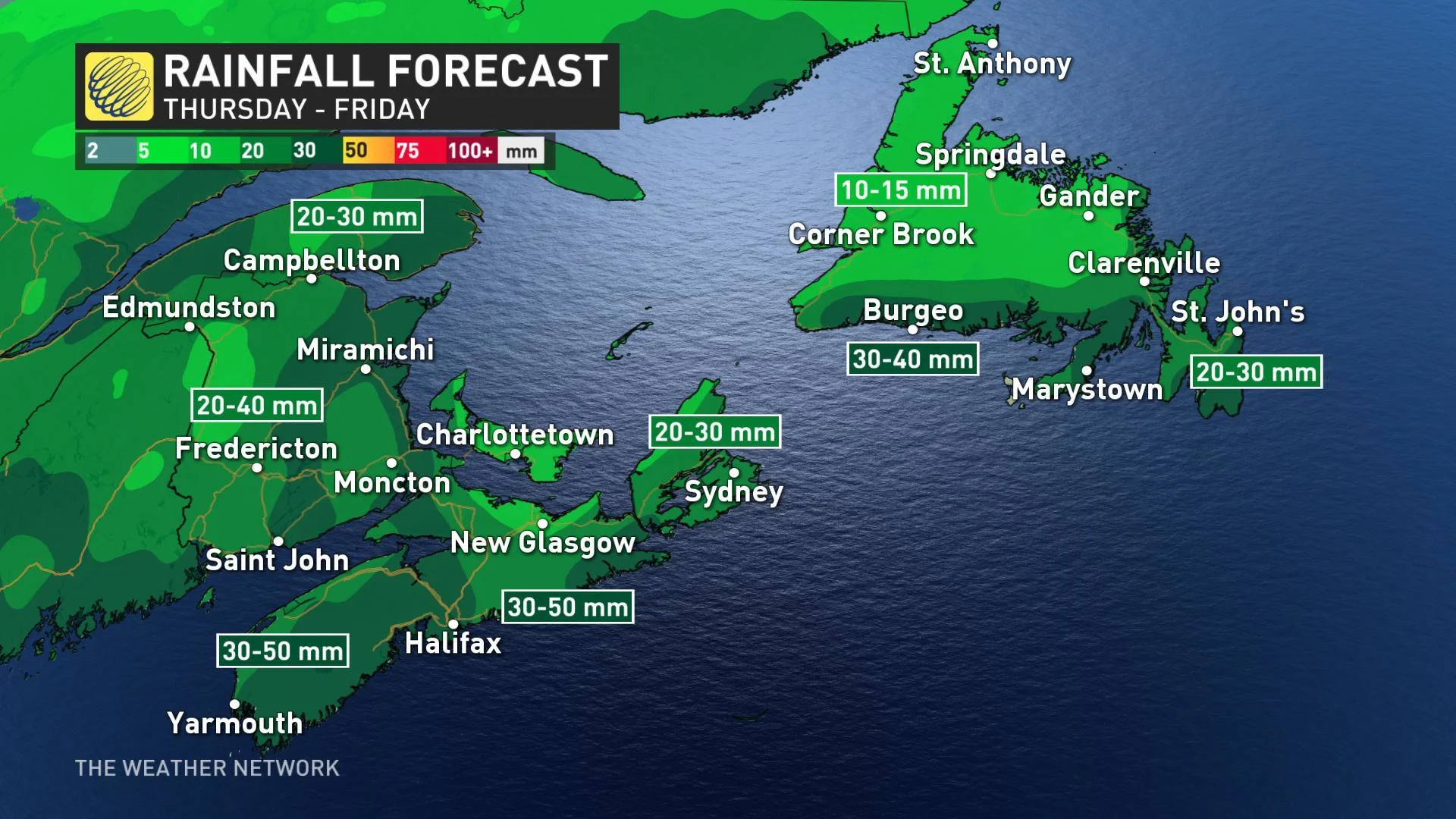
Heavy rain spreads across the Maritimes through Thursday, eventually pushing across Newfoundland by Thursday night
Widespread winds with gusts between 70-90+ km/h prompts wind warnings across much of the Maritimes
Rain showers linger into Friday before conditions dry out for the weekend
Stay on top of ALERTS in your area
WATCH BELOW: POWER LINE EXPLODES ON LIVE TV
This storm, which officially reached "bomb cyclone" status by dropping 24 millibars in pressure in 24 hours as of Thursday morning, is expected to remain powerful, although down from its peak as it moves over the Maritime provinces through Thursday.
According to the U.S. National Weather Service in Boston, the system steadily declined in central pressure through Wednesday.
"As of approximately 6 a.m. on Wednesday morning, the pressure of the storm was at 1018 millibars and then by Thursday morning at 6 a.m., it had dropped to 975 millibars, making it well within bombogenesis criteria," says Weather Network meteorologist Jaclyn Whittal. "The central pressure of 975 millbars would actually make it equal to the central pressure of a Category 1 hurricane."
HEAVY RAIN AND WIND WHIP THROUGH THE MARITIMES
By early Thursday morning, the first effects of this system were already being felt in parts of Nova Scotia with widespread rain and wind warnings covering much of the Maritimes.
The heaviest rain is expected across coastal areas of Nova Scotia where more than 50 mm could fall within only a few hours on Thursday. A storm surge warning was also issued for parts of the province's Atlantic Coast around noon with the risk for significant damage from high waves combined with the surge.
Flooding has already been reported in several communities, including Liverpool.
"Heavy downpours can cause flash floods and water pooling on roads," warns Environment Canada. "If visibility is reduced while driving, slow down, watch for tail lights ahead and be prepared to stop." Localized flooding in low-lying areas is possible.
SIGNIFICANT POWER OUTAGES POSSIBLE
Potentially more damaging for people in the region will be the system's intense winds, especially with recovery efforts still ongoing following the weakened trees and heavy impact from Dorian last month.
"This isn't a major hurricane or anything, but the trees are still in a weakened state because of Dorian, so these additional wind gusts have already been pushing some branches onto lines," says The Weather Network's Nathan Coleman out in the thick of the storm in Nova Scotia Thursday.
Wind gusts of 70 to 90 km/h are expected through the day, though some could reach or exceed 100 km/h in parts of the Maritimes.
Nova Scotia Power activated its emergency operations centre well ahead of the storm on Wednesday, with about 31,000 customers reported without power by 1:30 p.m. on Thursday.
The toppled crane that fell onto a Halifax building during Dorian, has been extra locked down in advance of the storm, Transportation and Infrastructure Minister Lloyd Hines told CBC News on Wednesday.
"We were able to secure and fasten the various parts of the crane and we're feeling confident that that work has been done and will prevail during the storm," he said.
STORM SURGE WARNINGS IN EFFECT
Higher than normal water levels and rough surf are also possible along the Atlantic coast near high tide on Thursday evening, with coastal flooding and potential also possible along the shoreline.
Marine Atlantic had already cancelled its 11:45 a.m. departures from North Sydney and Port aux Basques, Newfoundland on Thursday morning and advised that the evening crossings could be delayed as well.
The rain and wind will weaken as it tracks through Newfoundland by Thursday evening as conditions gradually dry out during Friday and the weekend.
"As the fall storm winds down on Friday, we'll see a very mild day for Newfoundland with rain," adds meteorologist Dr. Doug Gillham. "Things will be a bit cool through the weekend, but above seasonal temperatures dominate much of next week."
Thumbnail image submitted by Robert Deviller. Captured in Herring Cove, Nova Scotia.