10 magazine-cover worthy photos that capture the Prairie 2020 storm season
Kyle Brittain, a video journalist for The Weather Network, chased storms across Alberta and the Prairies during the 2020 storm season. Mission successful. Here are ten stunning events where Kyle was in the right place and the right time (and little stories on how he captured the photos).
1. Cochrane bolts
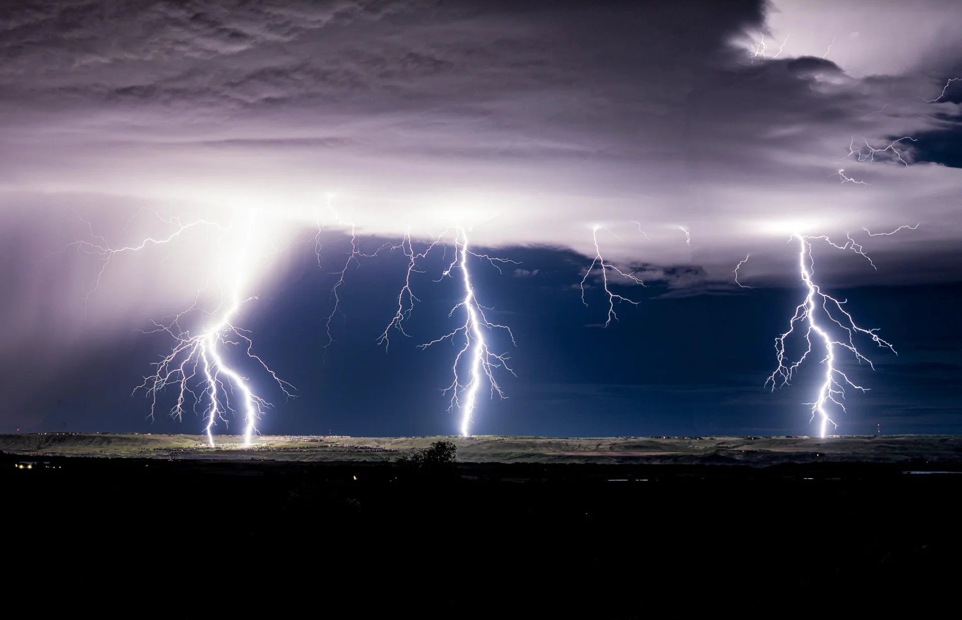
Late on May 30th and into the early morning of the 31st, I documented a series of impressive lightning storms that seemed uncharacteristically intense for the time of year.
It all began near Banff, where I watched intense lightning attack the still snow-laden peaks around the townsite in a wild scene that is quite rare for the area. My day was already made at this point, but a new storm began to approach the Cochrane area to my east as night began to fall.
I had yet to capture any decent nocturnal lightning in my life at this point and was eager to try out my new camera after spending the afternoon learning how to shoot it.
A few moments after pointing my camera north toward the twinkling lights of Cochrane, three intense, forked bolts all dropped to the Earth at the same time. My friends and I cried out in excitement.
2. Calgary Tower strike
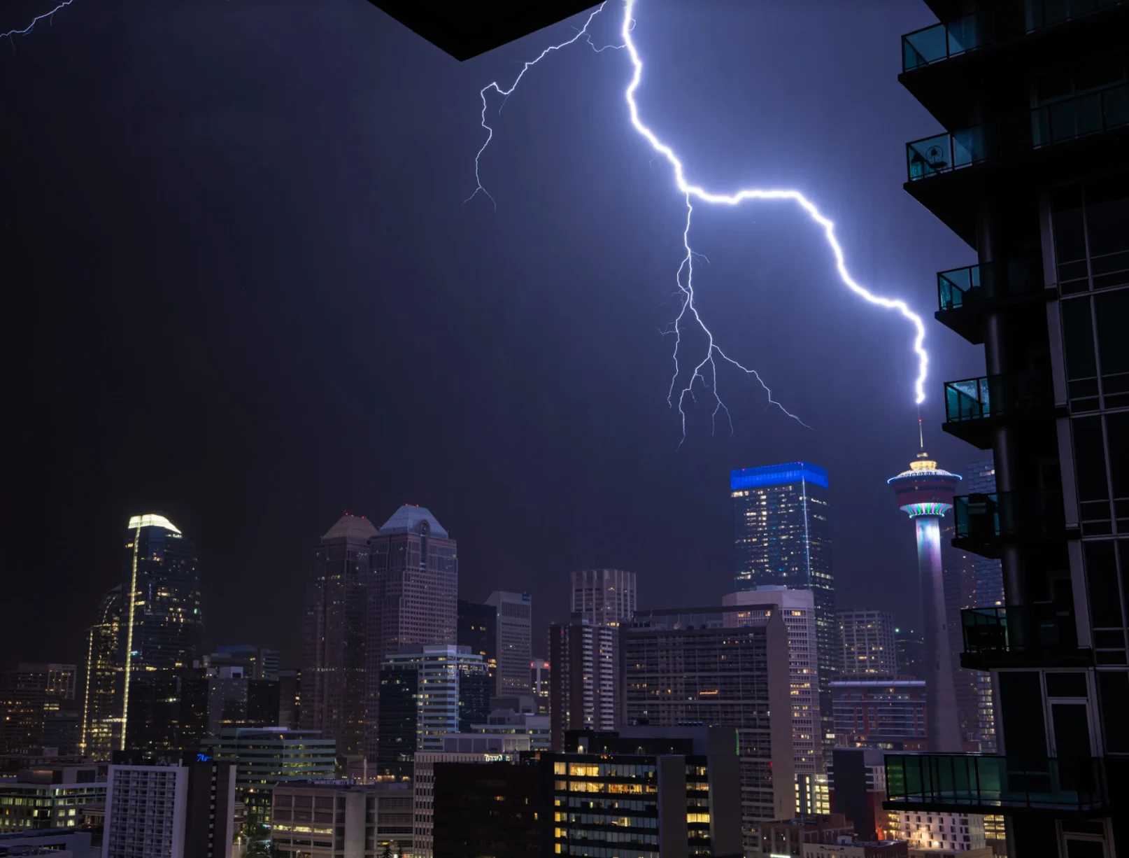
Following the two epic lightning storms just a few hours before, a third incredibly active line began to approach from the south, which would arrive in Calgary in the pre-dawn hours of May 31st.
It is always a special experience to see lightning hit buildings amid sprawling urban skylines, so I figured I would head home and document this one from my own balcony, which faces northwest toward the downtown core.
I stood at the rail and relished in the early season light show for over an hour before it came close enough that I felt I should head inside. As we watched the storm from the couch in the living room, a bright bolt of lightning hit what appeared to be the tallest building in the skyline, followed by a terrific clap of thunder.
We allowed the storm to move off before I went outside and grabbed the camera to begin playing back the images. Lo and behold, the strike had hit the Calgary Tower! I squealed with glee, as even I hadn’t seen a shot of our most famous landmark being hit for many years.
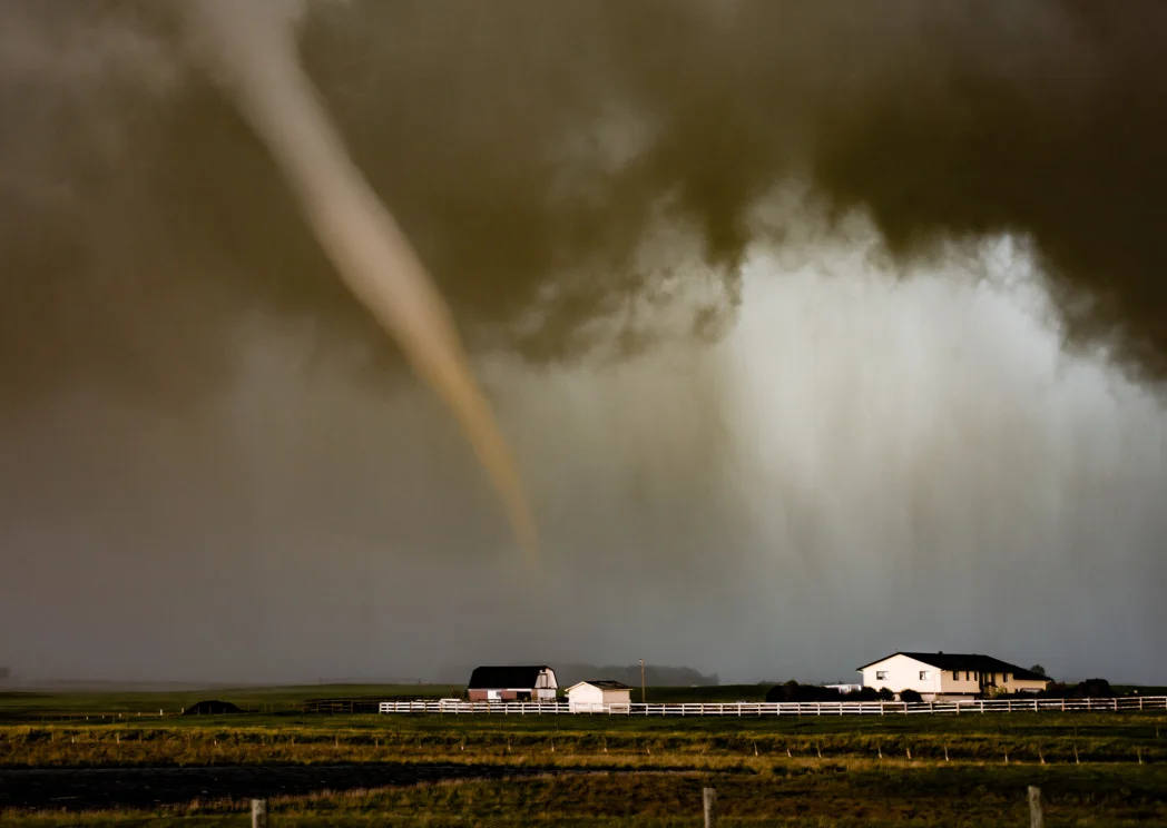
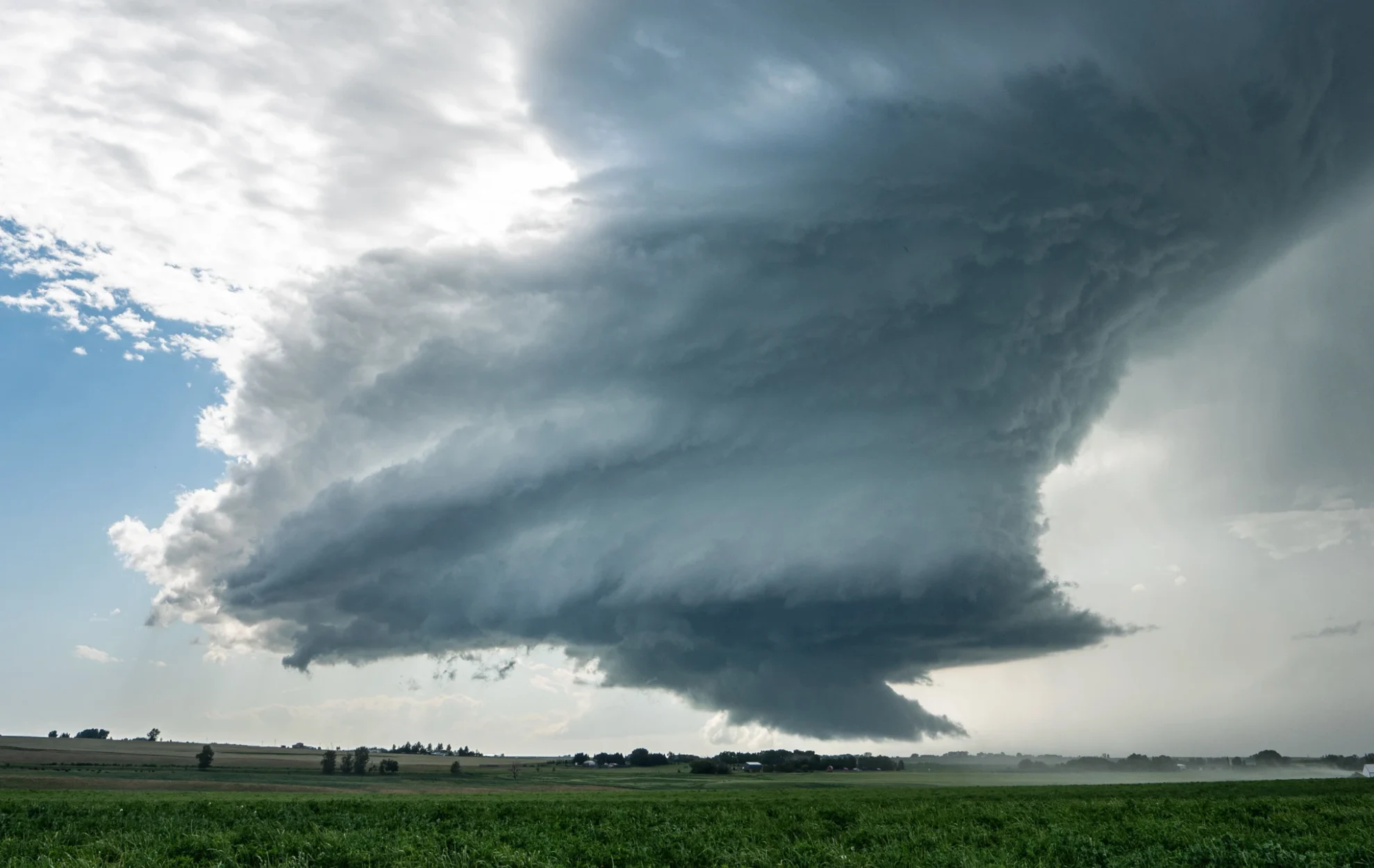
3. Chasers' first
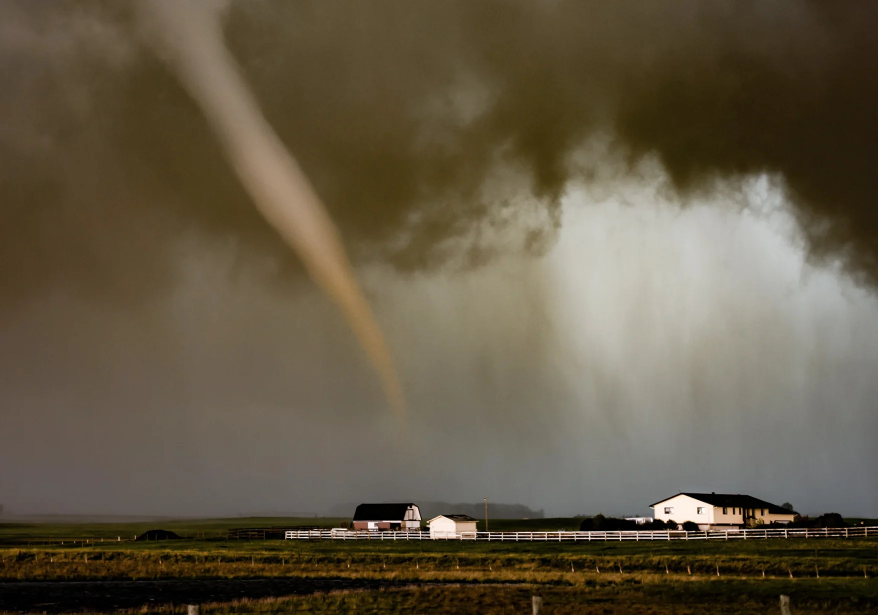
After a short sleep following the Calgary Tower lightning strike at about 3:30 AM, I was not looking forward to the long hike up to eastern Alberta to chase a well-advertised severe threat in the area later in the day.
However, somewhere along the way, we started seeing signs that the big show may actually end up back near Calgary, so we took the gamble by abandoning our target and headed back. Just as we made it to the line of storms, numerous funnel clouds began to appear along with the dark cloud bases.
Then, a particularly large and persistent funnel began to hang down from the ever-greener storm base, so we moved in for intercept. Just before we thought we would lose visual of it as rain began wrapping in, the funnel condensed all the way to the ground next to a farm, and we began to see a white mist whipping around on the ground associated with an audible whistling sound.
My heart rate soared as I realized it was about to cross the road in front of me, so I stopped to shoot video of the tornado as it passed just 50 yards away. The tornado moved out over a lake, roped out, and then dissipated.
It was my closest tornado encounter to date and the first tornado seen by Canadian chasers in 2020. For a frustrating few minutes, I was unable to find my phone to make a report, before pulling over and realizing it had somehow fallen into the garbage during all the excitement.
4. Monster cloud
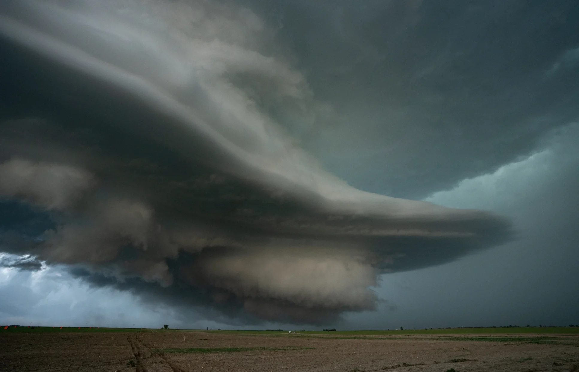
During the evening of June 13th, we sat south of Lethbridge and watched a couple of storm attempts fail in an otherwise classic severe weather environment. A third storm in Montana quickly became dominant and rolled across the border to where a number of eager storm chasers were waiting.
As it fed on increasingly unstable air, it grew into a monster that eventually dropped a weak tornado near Taber, before taking on some of the most impressive structures I’ve ever seen. You could see cloud matter forming before your eyes as the massive updraft inhaled humid air, which I vividly recall as having a scent that was reminiscent of the rainforests of Maui.
Just before dark, a gap up the side of the storm revealed a unique view of it, which appeared to be bursting into outer space, as constant forks of sideways lightning wrapped it in what looked like the edge of a plasma ball.
It would go on to drop terrifying, jagged hailstones the size of grapefruits, just a few hours after Calgary was also ravaged by what is now the costliest hailstorm in Canadian history.
5. Oil on canvas
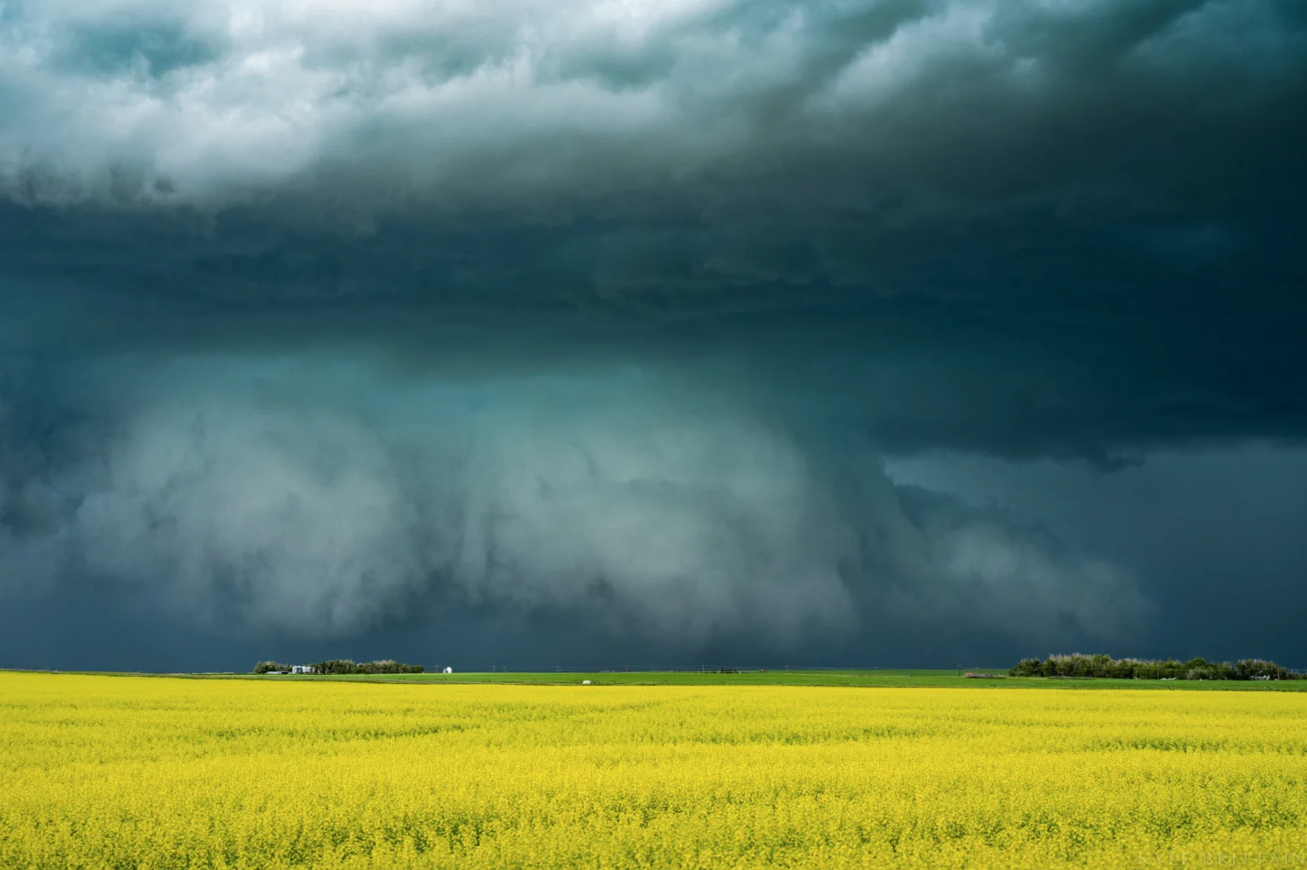
For the second June 27th in a row, I was able to chase severe storms on my birthday, and of course - alongside my friends – there was no other way I’d rather be spending it.
By late June, crops in southern Alberta were already coming along nicely, with the first canola fields flowering out in a burst of vibrant yellow.
As storm chasers, we call low-hanging wall clouds or shelf clouds “ground scrapers”, which brought about classic prairie scenes on this day as storm clouds with greenish hues passed over the photogenic croplands.
Storm chasers like flowering canola for two reasons: they provide a wonderful foreground for picturesque storms, and the crops themselves give off the moisture that goes on to fuel thunderstorms during the height of storm season.
6. Rocking horse
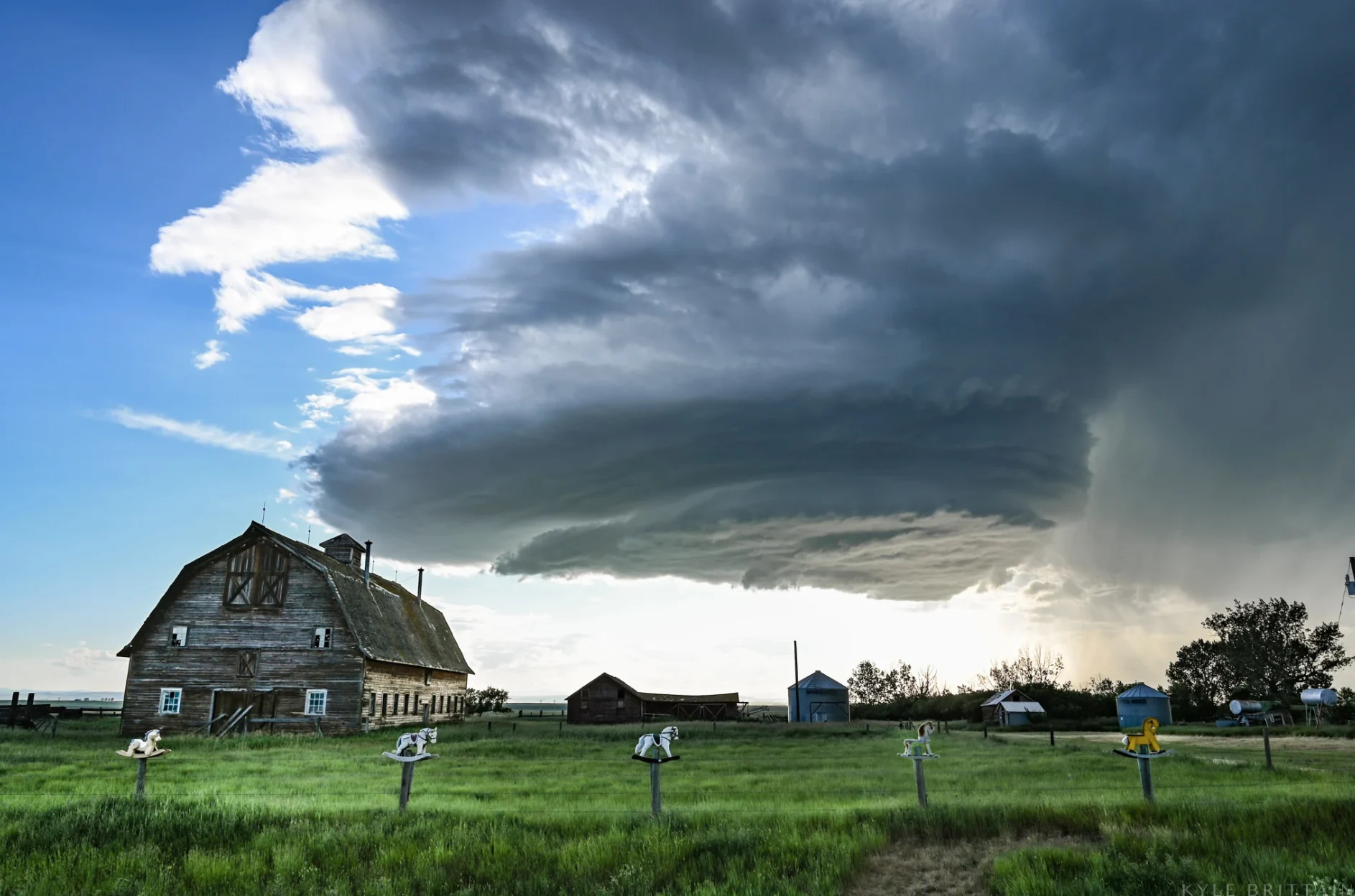
Any time thunderstorms could fire along the foothills both north and south of Calgary in the same day, I almost always opt for the southern play. I was pleased that July 6th would be one of these days, where gently rolling croplands, good roads, and excellent visibility extend from the Longview and Nanton areas right into Vulcan County.
Finding interesting foreground elements is desirable when trying to compose photos of storms, as they bring a sense of scale to the image and can convey a certain mood.
It also helps to mark down the location of abandoned barns, vehicles, or other structures for later reference in case a storm comes through. On this day, a slow-moving, sculpted supercell enabled me to run from barn to barn, capturing various scenes of abandonment with a classic Alberta storm as a backdrop.
I was particularly excited to finally capture a storm at this property, where the owner had mounted a collection of old rocking horses along the tops of the fence posts in front of the barn.
7. Postage stamp
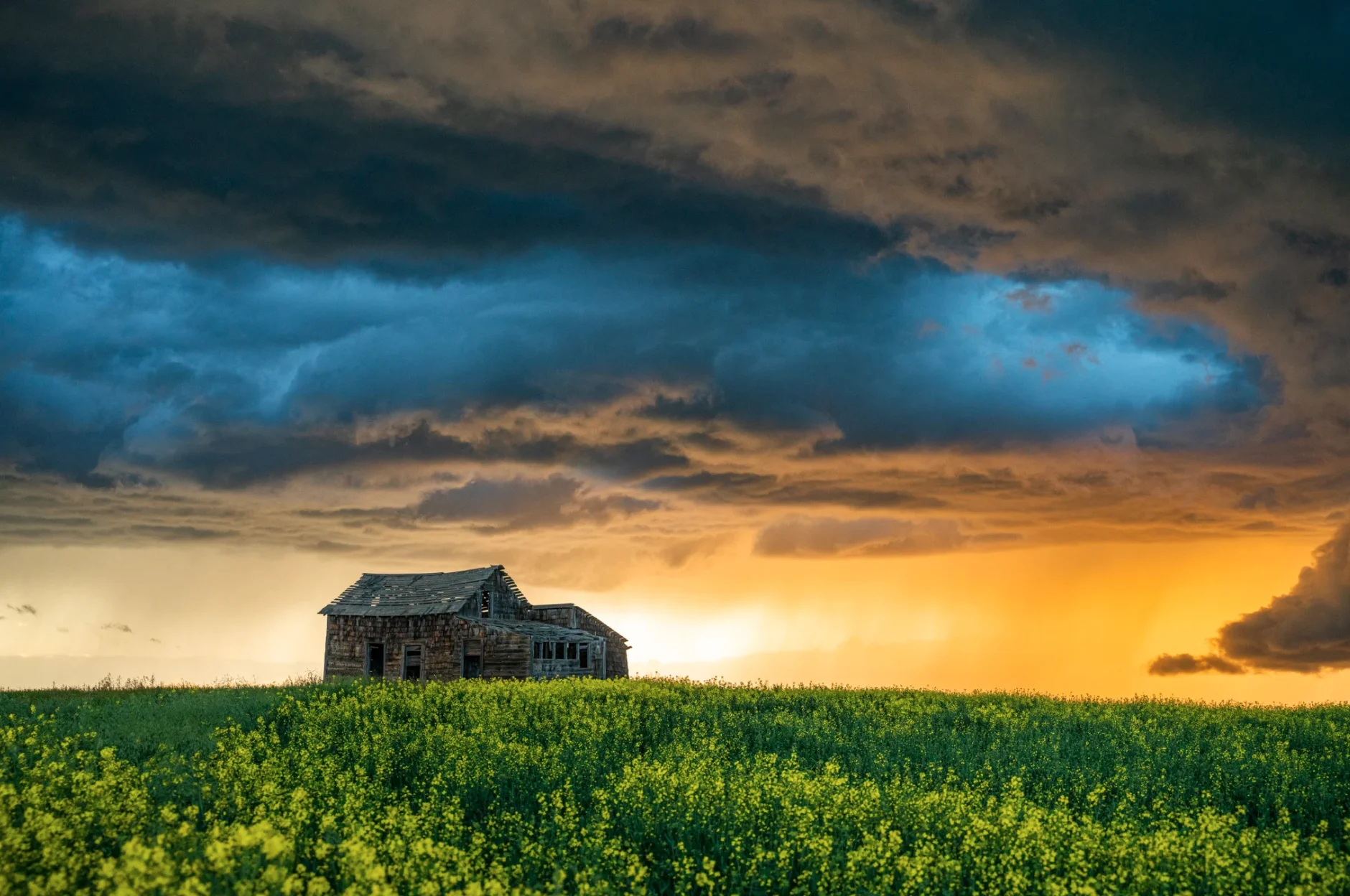
It doesn’t always take a severe storm to make a fantastically beautiful scene, so when I saw that a storm backlit by a clear, setting sun was approaching the abandoned Mossleigh Post Office building on July 17th, I set up for a while to take it in.
It was one of those scenes where despite the enveloping silence that surrounded me - save for the buzz of a few crickets and the roll of distant thunder - the sky was screaming, as the light danced among the clouds. It took me a few minutes to eventually pick my jaw up off of the fields.
8. Super city cell
July 23rd was yet another day where a potentially high-end severe weather threat was expected in central Alberta but ended up shifting back toward Calgary when stubborn cloud-cover limited storm development in the target area.
As we re-entered the city, massive vertical walls of towering cumulus exploded just to the west, before one tower became dominant and began to violently churn into the western suburbs like a tilted barber pole on full display to over a million people.
Our view was blocked for a few frustrating moments as we were forced to reposition in city traffic, but when we could see the storm base come out from around Signal Hill, we were alarmed to see what looked like a possible tornado just outside the city. Adrenaline coursed through my veins as I envisioned what might be about to occur in my hometown, but thankfully, the storm carried on to the east without causing much damage.
Eventually, it became part of a swarm of beastly supercells that tracked east across southern Alberta during the evening, bringing scenes of tremendous storm structure.
9. Mighty mountains
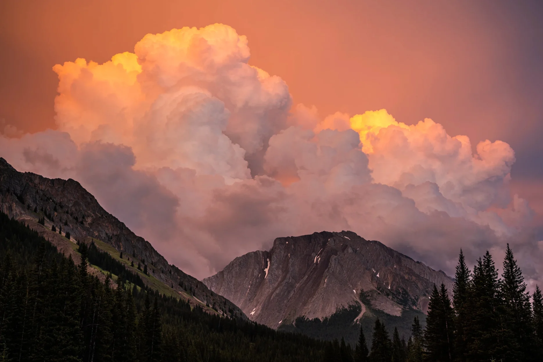
July 30th was one of several days during the end of July that had tennis ball-sized hail along the foothills, as storm season peaked in instability for the summer.
A dominant but slow, lumbering storm developed just north of the Stoney Nakoda Resort, before pelting hundreds of vehicles stuck in a traffic jam on the Trans-Canada Highway with windshield-shattering hail.
The storm would go on to continue down the Rocky Mountain Front west of Calgary throughout the evening, so for the second time in the summer, I decided to try for a mountain intercept along Highway 40. Part of the storm spilled over the rim of the Rockies, just as an unobstructed setting sun hit the backside of it with splendid orange light.
It is a truly unique opportunity to see severe storms in such a beautiful and rugged environment, so we marvelled as great mountains of water towered above the mighty mountains of rock.
10. May appear closer
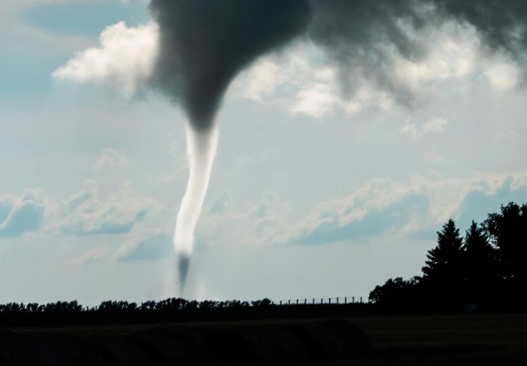
It was August 13th – just six days after the killer tornado near Virden, Manitoba. This area of the eastern Prairies has sometimes been coined “Canada’s Tornado Alley”, due to the occurrence of significant tornadoes in the region that are similar in character to their US counterparts.
However, they only tend to occur every few years, with a number of high-end setups failing to produce due to a strong cap, leaving chasers with a long, boring drive home. Perhaps due to the fact that the skies seemed to be awakening in the area this year, I decided it would be worth the trek from Alberta.
By mid-afternoon, rapid thunderstorm development began to occur near Virden, with a tornado warning being issued shortly after for the dominant storm I was pursuing.
Then, just before I disappeared into the rain, I happened to look into my rearview mirror and spotted a funnel cloud reaching down. It took me off guard, as it wasn’t in the area of the sky I would think to look.
Mine turned out to be a very unique perspective, as the sun shone brightly on the other side of the tornado, making it appear ghostly white and rather translucent.
As I moved in closer toward my first Manitoba tornado, I was struck by the fact that I could actually look out the windshield at the twister that was the cause of my phone screaming with a tornado alert.