Intense snow squalls, followed by temperature dive in southern Ontario
Digital Reporter
Thursday, February 12, 2015, 2:33 PM - Snow squalls will continue to impact parts of southwestern Ontario Thursday, leaving motorists with less than ideal conditions on the roadways.
"Local accumulations of up to 10 cm per hour will be possible," said Environment Canada in a special weather statement early Thursday morning.
Motorists are urged to use extra caution, especially along Highway 21, as blowing snow could reduce visibility to near zero.
White-out conditions prompted helicopters to land on the highway in Strathroy, Ont. Thursday afternoon.
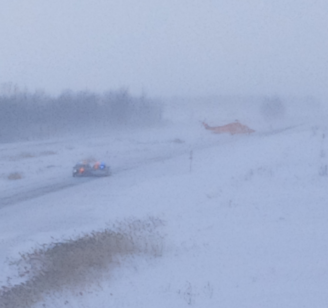
"None of the choppers can go any further, the pilots can't see," said Weather Network camera operator Mark Rozitis, who was at the scene.
Dangerous cold to grip southern Ontario, including the GTA
While the Greater Toronto Area will remain relatively snow-free Thursday, it's the dangerous wind chills that will have people wanting to stay indoors over the next couple of days.
A strong cold front pushing through southern Ontario will usher in a major drop in temperatures, leading to potentially record cold for later in the week.

"Friday will prove to be a cold day to start, with temperatures into the -20s and daytime highs rebounding only a few degrees," says Weather Network meteorologist Erin Wenckstern.
That's only core temperatures, and it may threaten the temperature record for that day, according to Dr. Doug Gillham, another meteorologist at The Weather Network.
Falling temperatures today for the GTA, reaching -17 for PM commute & windchill near -30; Record low of -23.2C at Pearson in jeopardy Friday
— Doug Gillham (@gtaweather1) February 12, 2015
"The record low temperature at Pearson Airport for February 13 is -23.2ºC set in 1979," Gillham says. "The wind may stay up just enough Thursday night to prevent the actual temperature from getting quite that low, but that wind would also produce a wind chill near -30."
Then, there's a burst of "Siberian" air set for Sunday as well, and Gillham says it'll likely be colder than Friday (although maybe only because the record for that day is -31.1ºC).
"This is pipe-bursting cold," Dr. Gillham adds. "Wind chill values into the -30s were the coldest temperatures seen in southern Ontario last year."
Snow squalls could also be an issue in some places -- especially the Niagara region and from Sarnia to Strathroy. Frostbite and hypothermia can set in quickly in extreme cold.
"We're looking at dangerous wind chill values Saturday night into Sunday," Dr. Gillham says.
As for Family Day itself, Monday, you'll want to read Gillham's piece on what to expect on what, for many, will be the last day of a long weekend.
![]() EXTREME WEATHER TOOL KIT: Be prepared for winter weather with The Weather Network's online essentials: ALERTS | HIGHWAY CONDITIONS | UPLOAD PHOTOS/VIDEOS | LATEST NEWS | FOLLOW ON TWITTER
EXTREME WEATHER TOOL KIT: Be prepared for winter weather with The Weather Network's online essentials: ALERTS | HIGHWAY CONDITIONS | UPLOAD PHOTOS/VIDEOS | LATEST NEWS | FOLLOW ON TWITTER
WATCH BELOW: What calls for a wind chill warning?
With files from Cheryl Santa-Maria