Spring Forecast 2016 and a sneak peek at summer, here
Visit this Spring Forecast Guide to the Season for the 2016 Spring Forecast, Summer Weather Preview and much more.
Meteorologists
Monday, March 21, 2016, 10:10 AM - How will El Niño impact Canadian weather as we transition into spring? Where will the cool temperatures and storms linger, and who can expect an early taste of summer?
The summer sneak peek and full details on spring below in The Weather Network's 2016 Spring Forecast.
Late Winter/Early Spring Pattern
Here’s a look at the pattern as winter transitions to spring.

While the final weeks of winter brought some spring-like weather to much of Canada, the first few weeks of spring will feature a few parting shots of winter weather from the Prairies to Atlantic Canada. March is well known for stormy weather and this year will be no exception, especially from the Great Lakes to Atlantic Canada with the threat of nor'easters. Early April looks especially chilly relative to local average temperatures from the eastern Prairies to the Maritimes. Meanwhile, across western Canada above seasonal temperature will dominate.
Mid-to-Late Spring Pattern
Moving ahead into the spring season, we expect the amplified jet stream pattern to relax, allowing above seasonal temperatures to dominate across most of Canada, much like what we saw for extended periods during the fall. However a dip in the jet stream near the B.C. coast during late spring will bring temperatures back closer to seasonal for British Columbia, along with periods of wet weather.
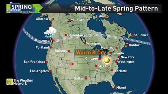
Across the Great Lakes region, we expect a trend towards drier than normal weather, especially during late spring. While there will be sufficient moisture to start the growing season, this trend towards warm and dry weather could be cause for concern for agriculture as we head towards summer.
Spring Temperatures
Looking at the meteorological spring months of March, April, and May, the map below shows the overall temperature pattern that we expect for the season as a whole.
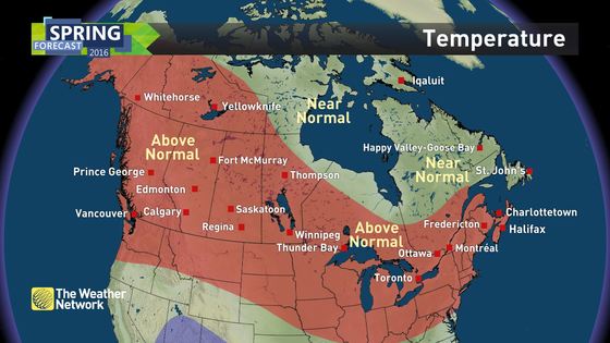
We expect a warm spring from coast-to-coast, with the only exception being Newfoundland, northern Quebec, Nunavut, and areas near Hudson Bay. In these regions, temperatures should average out close to what we typically see during the spring.
Spring Precipitation
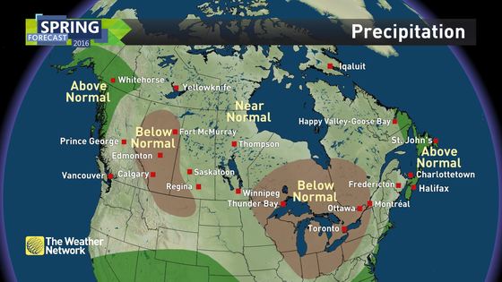
With regard to precipitation, an active storm track near the Atlantic coast is expected to bring above normal precipitation to most of Atlantic Canada (near normal for New Brunswick), as frequent systems will bring rain and the threat for a few more rounds of late-season snow.
The B.C. coast will remain wet as well, though breaks in the pattern at times which should allow Vancouver Island and the Lower Mainland to end up near normal for the season.
In the Great Lakes region, a dry spring is expected (especially late), as the active storm track remains to the east. Dry conditions will prevail in the western Prairies as well.
Summer Preview
Looking even further ahead to the summer, here is a preliminary look at the trends we expect in the overall pattern. We will release our full summer forecast in May.
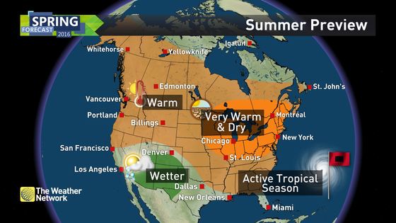
From mid-summer 2013 through most of last summer (2015), we saw a persistent pattern across North America which featured warm and dry weather across western Canada, with cooler weather for most of eastern Canada. However, this pattern began to break down towards the end of last summer and that trend should continue for this summer.
While most of Canada will see warmer than normal weather through the summer, the focus of the summer heat is expected to be across the Great Lakes and into the Maritimes. The west will still have its share of hot and dry weather, but excessive heat and drought should not be as big of a concern as it was during the past two summers.
From the Great Lakes to the Maritimes, it is still too early to know whether this summer will be remembered as truly hot and dry, or just warmer than the past few summers. This will be more clear when we release our full summer forecast in May.
We are also keeping our eye on the potential for the tropical season to be considerably more active than normal this year in the Atlantic Basin. After a lull in hurricane activity for the past couple of seasons, there are indications that the tropics will come roaring back to life in 2016.
Visit this Spring Forecast Guide to the Season for the 2016 Spring Forecast, Summer Weather Preview and much more.


