Rare thunder snow caught on camera
Digital Reporter
Thursday, November 20, 2014, 12:34 PM - Hearing thunder during a snowstorm is relatively rare, but not unheard of this time of year.
Blinding lake-effect snow, at times accompanied by thunder and lightning, bombarded much of the the Buffalo, New York earlier this week, causing whiteout conditions, shutting down large swaths of interstate highways and forcing schools and businesses to close.
Lake-effect snow is produced during cooler atmospheric conditions when cold winds move across long expanses of warmer lake water, providing energy and picking up water vapour, which freezes and is deposited on the leeward shores.
RELATED: The Science Behind Lake Effect Snow: How did so much snow fall on Buffalo on Tuesday?
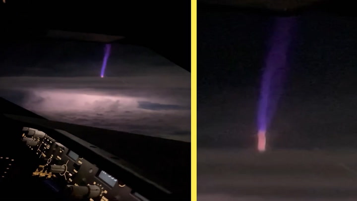
Weather Network meteorologist Kelly Sonnenburg calls it 'thunder snow'.

"The ingredients are there again for Buffalo to see another round of thunder snow today," she said. “The air is below zero and the water is around 7° Celsius. That steam comes up and wants to rise. That rise...creates a thunder storm but it’s so cold it doesn't rain. It just snows.”
The region is being hit by another round of punishing lake-effect snow Thursday. Around 180 cm is on the ground, with an additional 60 to 90 cm expected.
"A deep trough is persisting over the Great Lakes, which is supplying that cold air that's needed for lake effect snow," says Sonnenburg. "Around 7 to 8 cm could fall per hour -- but the heaviest bands will be just south of the area that was hit the hardest earlier this week."
Making matters worst will be a rapid warm-up beginning on the weekend.
Buffalo resident captures "thundersnow". 3' of snow expected today, on top of 6' on ground. https://t.co/uGGlffnp1v pic.twitter.com/mHGonxUf7W
— Matt O'Donnell (@matt_odonnell) November 20, 2014
"The combination of at least some rain and major snowmelt will bring the risk for significant flooding to the lake effect areas, both for small streams as well as some of the larger creeks and rivers," says Dayna Vettese, another meteorologist at The Weather Network. "This would include the Buffalo area creeks, Cattaraugus Creek and the creeks that drain the Tug Hill region."
"In urban sections of south Buffalo ponding/flooding may also occur as the large volume of melt water overloads drainage systems."
Be sure to check back for updates as we continue to monitor this developing system.
RELATED VIDEO BELOW: How residents are dealing with all the snow in Buffalo.