'Strange' visuals beamed in as Mars explorers end vacation
Meteorologist/Science Writer
Monday, July 6, 2015, 9:43 AM - What I Did On My Summer Vacation took on an interplanetary theme recently, as NASA's Mars rovers and orbiters beamed back pictures of some strange-looking features from the Red Planet.
For roughly three weeks in the middle of June, the various robotic explorers on and around Mars have been taking a little vacation. Quite simply, and literally, the Sun had interrupted any work they could have been doing, due to a phenomenon called Mars Solar Conjunction. With the bulk of our home star directly in between Earth and Mars, and the potential for the charged particles it sends streaming out into space to mess up bits of the data being transmitted back and forth between the two planets, the robots and their handlers back here on Earth were given most of the month off.
However, now that Mars and Earth have a more clear line of sight to each other, the Opportunity and Curiosity rovers have been sending back their data, and the pictures they're showing us reveal some pretty weird "sightseeing attractions" in their vicinity.
This formation near the Opportunity rover, named the Lindbergh Mound to honour Charles Lindbergh's solo non-stop trans-Atlantic flight, sits in the middle of a small crater known as "The Spirit of St Louis". Viewed from different angles and distances in April and May, it already registered as a bit of an anomaly at the time, as there's no indication of how this "disintegrated rubble pile" originated.

A black & white image of the entire Lindbergh Mound. Credit: NASA/JPL-Caltech

An amazingly detailed anaglyph 3D version, captured by Opportunity's stereographic mast cameras. Credit: NASA/JPL-Caltech
|
|

The image to the right is a false-colour version of the left side of the mound, snapped through various filters by Opportunity's left mastcam, and then combined to produce a red-green-blue image that is probably fairly close to what human eyes would see on Mars.
![]() RELATED: What is "Mars Solar Conjunction"?
RELATED: What is "Mars Solar Conjunction"?
On roughly the other side of the planet from Opportunity, Curiosity is still investigating Aeolis Mons (aka Mount Sharp).
In among the formations at the base of this layered mountain, the rover turned up some rather peculiar-looking rocks - at least peculiar for what you'd think to see on Mars.
Below is one example, taken in black and white by the rover's right MastCam on Sol 1027 (June 27, 2015).
|
|
|


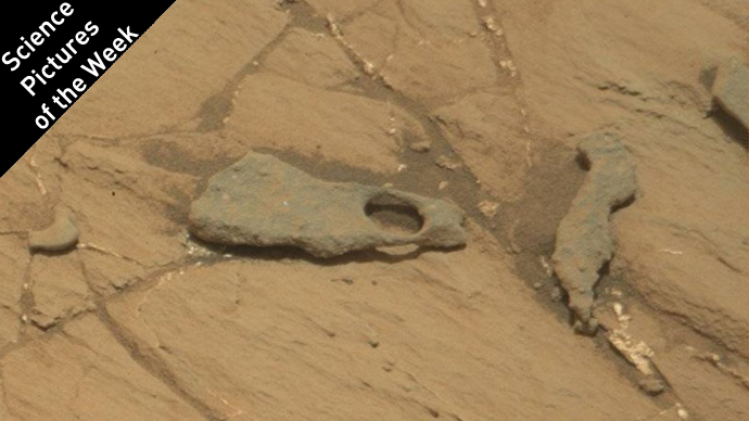
Stranger still, a short distance away, Curiosity snapped a colour image of another piece of rock, which appears to have a nearly perfect circle worn through it.
|
|
|


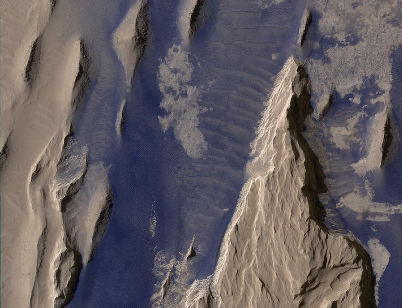
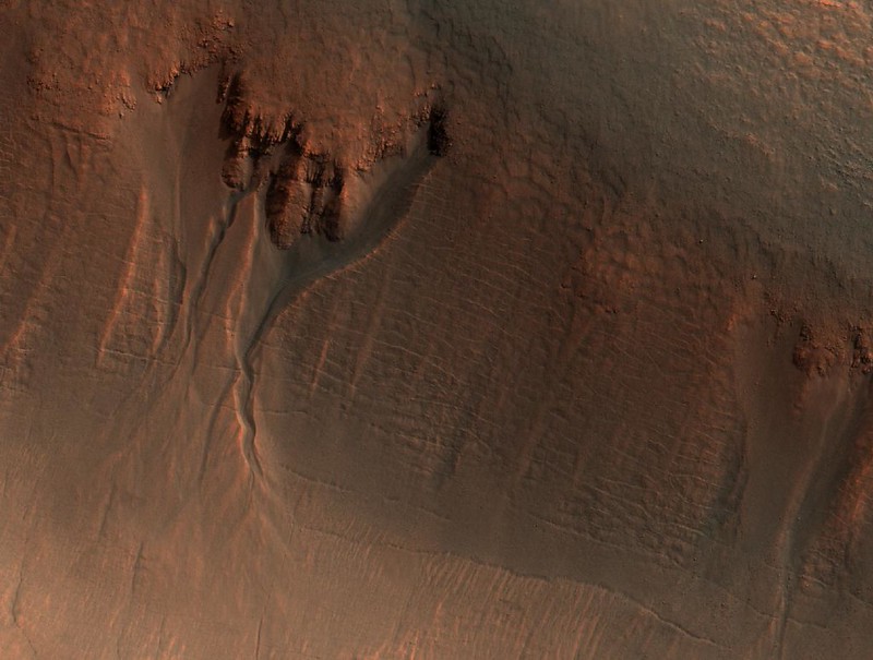
Other missions are sending back new data as well, including the Mars Reconnaissance Orbiter. These particular images take on a special significance when it's noted that some of the people guiding this 226th cycle for MRO's HiRISE camera are students and faculty students at the Centre for Planetary Science and Exploration (CPSX), at London's University of Western Ontario.
Dr. Livio L. Tornabene, the project lead at Western University, and CPSX PhD student Tanya Harrison, provided the following images and captions as an example of the work they are doing on this, their second, imaging campaign with the MRO HiRISE team at the University of Arizona.
"This beautifully contrasted infrared-colour image shows a close-up of the western Medusa Fossae formation (MFF) - approximately 600 by 900 metres. Combined infrared, green and blue image filters look 'past' the ubiquitous red of the Martian landscape to reveal added details. Here we can see dust-covered rocky, bedrock surfaces (beige) and a bluish-tinted sand sheet and dunes, which are thought to be locally derived (i.e., from the bedrock that lies beneath the dust). If true, this has implications for the composition of the MFF, which has been highly debated over the years." - Livio L. Tornabene. Image Credit: NASA/JPL-Caltech/UA
"This simulated true-colour image of gullies in the northern wall of an unnamed crater in Utopia Planitia covers an area of approximately 750 by 1100 metres. The banked, sinuous shape of gully channels suggest that water was involved in their formation. The source of this water however is a subject of debate. Hypotheses include melting of snow or near-surface ground ice. Other features in this scene also suggest the past (and possibly present) presence of snow or ground ice in this region. For example, the “mantle” deposit on the crater wall displays polygonal fractures. Polygons on Earth are associated with periglacial activity (i.e., processes that occur from the presence of ground ice). The mantle itself may be the remains of a dusty snowpack deposited in Mars' recent past. At the base of the mantle are fractures associated with the slumping of these deposits under its own weight and Martian gravity. The largest gullies cut into these mantling deposits, and in some places obscure the underlying fractures at the base of the crater wall. This indicates that the largest gullies are younger than both the mantle and the fractures." - Livio L. Tornabene and Tanya Harrison. Image Credit: NASA/JPL-Caltech/UA
The CPSX team continues to gather more images during HiRISE's 226th campaign. Follow them on Twitter for more updates throughout the cycle, which will no doubt reveal even more amazing views of the Red Planet.
Sources: NASA/JPL-Caltech MER | NASA/JPL-Caltech MSL | CPSX


