Hurricane Gonzalo and its potential impact on Newfoundland this weekend
Meteorologist
Wednesday, October 15, 2014, 5:22 PM - The Atlantic hurricane season is about to make headlines.
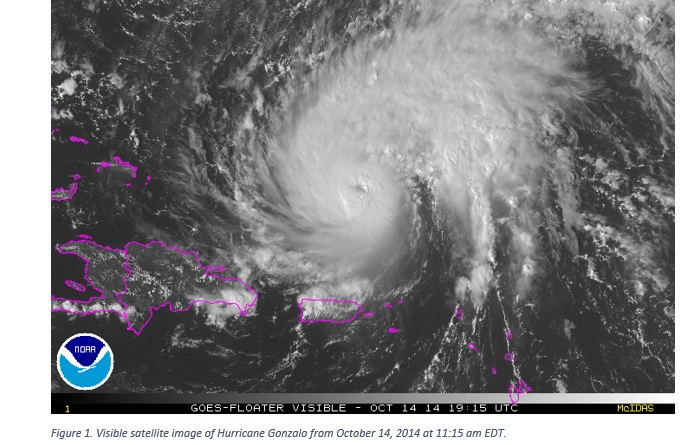
Up to now, the Atlantic hurricane season has been relatively slow in comparison to previous years. In fact, we are now just getting to our seventh named storm of the season. Hurricane Gonzalo has reached Category 3 status, making it a major hurricane, on the Saffir-Simpson scale. Gonzalo is forecast to continue to strengthen over the next few days affecting Bermuda as a major hurricane through the day Friday. Before Gonzalo affects Bermuda the current National Hurricane Center’s forecast expects it to peak as a Category 4 hurricane on Wednesday with winds near 222 kilometres per hour.
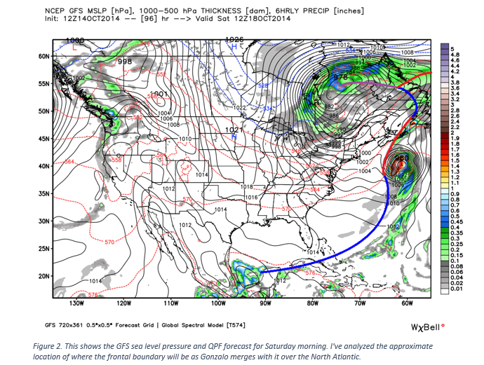
The Weather Network will be keeping a close eye on Hurricane Gonzalo as some long range forecast models show the potential that Gonzalo will impact Atlantic Canada this upcoming weekend (October 18-19). It won’t impact Atlantic Canada with the same strength Bermuda will be experiencing, but it's a storm we need to keep monitoring. As Gonzalo pushes north of Bermuda it will weaken as it merges with cold front and upper trough that is associated with the current system affecting a large chunk of North America, as seen in Figure 2.
![]() EXTENDED ACTIVE WEATHER COVERAGE: Tune in to The Weather Network on TV for LIVE, on-the-ground updates from our Atlantic Canada correspondent, Nathan Coleman
EXTENDED ACTIVE WEATHER COVERAGE: Tune in to The Weather Network on TV for LIVE, on-the-ground updates from our Atlantic Canada correspondent, Nathan Coleman
The frontal boundary and the upper level winds associated with the system will increase wind shear leading to Gonzalo’s weakening and begin a transition into a post tropical system. Another significant component in Gonzalo’s weakening will be the fact that it will push into the cool waters of the north Atlantic.
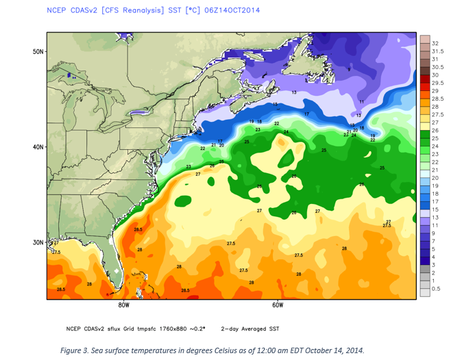
In order for a hurricane to thrive it requires very little wind shear and warm ocean water usually at or above 26-27 degrees Celsius. Figure 3 below shows water temperatures through the central and northern Atlantic.
Favourable water temperatures look to end right around Bermuda dropping off significantly into the North Atlantic around the Maritime provinces. Wind shear, which is the change of wind speed and direction with height, is detrimental to hurricanes as it causes the strong convection around the eye to pull away from the center of the hurricane and tilts the vortex in the vertical. Hurricanes thrive off the release of latent heat and moisture from this convection thus removing it will cause weakening and a transition over to a post-tropical storm.
NEXT PAGE: HOW WILL THE GONZALO SCENARIO PAN OUT?


