Here's what 160 mm of rain in Atlantic Canada looks like
Digital Reporter
Friday, October 2, 2015, 9:30 AM - As a cold front slowly exits Atlantic Canada, rain continues in parts.
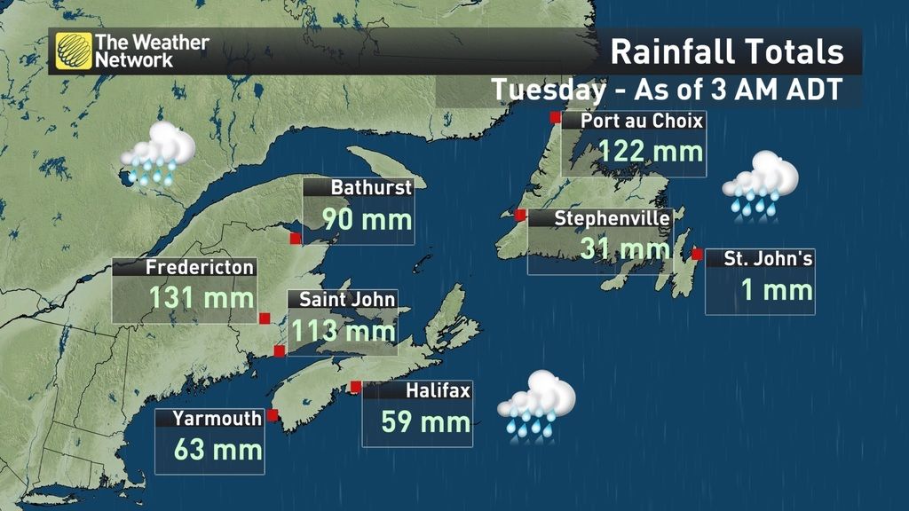
Since Wednesday this drenching system has dumped over 160 mm in some places.
Heavy downpours Wednesday into early Thursday led to the death of a man in New Brunswick who was trying to hook up his sump pump when a retaining wall fell on him, according to police. The rain also damaged infrastructure, knocked power out and lead to the closure of several roads and schools.
"Drainage systems have become overwhelmed in many paces and there are reports of localized flooding," New Brunswick's Emergency Measures Organization said in a statement. "The impact upon private homes is reported to be significant."
More than 5,000 homes were left without power around the Fredericton area Thursday morning, according to New Brunswick Power.
Although all rainfall warnings have ended in Atlantic Canada, more rain is on the way for parts. Eastern Newfoundland, Nova Scotia and P.E.I. are forecast to see rain Friday. The wet conditions are expected to continue into Saturday before easing off into the evening over Nova Scotia and the Avalon.
Coastal regions of Nova Scotia from Shelburne to Halifax are forecast to receive an additional 25 to 35 mm of rain Friday. Meanwhile, places like St. John's in eastern Newfoundland could see rainfall amounts under 15 mm.
@weathernetwork Massive sinkhole in Long Point,NB. Man escaped with his life- his car now floating in the bay. pic.twitter.com/tyBfUwLFKQ
— Nathan Coleman (@NateTWN) October 1, 2015
Road to our camp on the #MiramichiRiver in #NewBrunswick is washed out today. We are not going anywhere... pic.twitter.com/dqhNjsUNsx
— WILSON'S Fly Shop (@WILSONSflyshop) October 1, 2015Route 101 into #Hoyt, NB flooded. Here are images from today compared to Google Maps images #nbstorm #nbflood pic.twitter.com/rN1s6eT1Ii
— Dayna Vettese (@daynavettese) October 1, 2015
Road damage is everywhere but I was able to get by this one fairly easily. #nbstorm pic.twitter.com/aCQzu6wtvK
— Mark Robinson (@StormhunterTWN) October 1, 2015
Water surrounds this barn. And while the water is slowly receding, it's going to take a while before things are dry. pic.twitter.com/yVJvrzO5pD
— Mark Robinson (@StormhunterTWN) October 1, 2015
Heavy rain. 40 mm of rain fell. Winds gusting to 75km/h. Live from Sluice Point @weathernetwork @KrissyVann @NateTWN pic.twitter.com/DitimOsSSp
— Lucas Bourque (@Merci_Luke_) September 30, 2015

