Atlantic Canada sees record-breaking rain, more on the way
theweathernetwork.com
Friday, October 2, 2015, 9:54 AM - Although all rainfall warnings have ended in Atlantic Canada, a slow moving cold front is expected to bring more rain to parts.
At least one person is dead following heavy rainfall in New Brunswick.
According to CBC, a 51-year-old man in Berwick, NB, died Thursday after a retaining wall fell on him as he was trying to hook up his sump pump.
Emergency officials have also reported an increase in car accidents, amid flooded roadways and threats of hydroplaning.
The stationary cold front is slowly moving its way out of Atlantic Canada, however, eastern Newfoundland, Nova Scotia and P.E.I. are forecast to see rain Friday. The wet conditions are expected to continue into Saturday before easing off into the evening over Nova Scotia and the Avalon. Winds out of the northeast could reach up to 70 km/h for the Atlantic region Friday. While a drier weekend is in sight, meteorologists are keeping an eye on Hurricane Joaquin for a potential impact through next week. As a result, a tropical cyclone statement is in effect for all of Nova Scotia and Newfoundland.
Coastal regions of Nova Scotia from Shelburne to Halifax are forecast to receive an additional 25 to 35 mm of rain Friday. Meanwhile, places like St. John's in eastern Newfoundland could see rainfall amounts under 15 mm.
Rain fell for nearly 48 hours in portions of northern Newfoundland Thursday before it tapered to drizzle by the evening hours. Port Au Choix saw over 120 mm, while places like Daniel's Harbour received just over 85 mm.
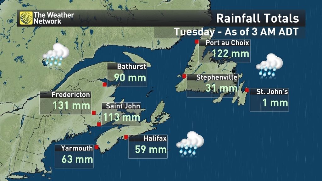
The slow moving cold front brought torrential downpours to New Brunswick and Prince Edward Island Wednesday night. Up to 140 mm fell in Fredericton, making it the city's wettest day on record. Meanwhile, Kouchbouguac saw almost 170 mm. As the system tracked across P.E.I., heavy rain brought an estimated 160 mm to places like North Cape.
Power outages affected hundreds of customers in parts of New Brunswick and Nova Scotiawhen winds picked up earlier in the day.
After the highest tides in 18 years in the Bay of Fundy peaked on Tuesday, the chance of coastal flooding triggered by storm surge during periods of heavy rain remains a potential threat over the next few days.
Tune into The Weather Network on TV for continued updates on this system.
MORE VIDEO: Sinkhole swallows car in Nova Scotia


