Daily Weather Brief: Cold streaks broken, but more chills on the way
Digital Reporter
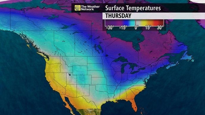
Thursday, March 5, 2015, 6:48 AM - On Tuesday, The Weather Network released its 2015 Spring Outlook (Check it out online here). Cold streaks were broken in Ontario and Quebec Wednesday, but temperatures have taken another plunge. That trend will extend to the east coast while the Prairies prepares for a warm-up. Here's your Thursday weather brief.
Atlantic Canada
- Maritimes: A 'conveyor belt' of moisture could bring flurries to the Atlantic-facing coast of Nova Scotia Thursday. A big cool down is headed to eastern Canada as an arctic front moves through. "Temperatures will be 10-15 degrees below normal Thursday into Friday," says Weather Network meteorologist Dayna Vettese. The chance of a warm-up is in store for the end of the weekend.
- Newfoundland: Conditions are still a bit blustery across the province. Up to 15 cm of snow could fall in Newfoundland between Wednesday morning and Thursday. A weak disturbance could bring additional light flurries to Newfoundland this weekend.
- Atlantic Canada Spring Outlook: The stormy pattern across Atlantic Canada this winter will likely continue into April with the potential for late-season winter-like storms, according to The Weather Network’s 2015 Spring Outlook for March, April and May.
Ontario and Quebec
- Ontario: After 37 days of freezing temperatures, southern Ontario's the cold streak came to an end Tuesday night, climbing above 0C in several communities. It was a frigid start to the morning in southern Ontario Thursday. Temperatures dropped significantly overnight into Thursday, causing any slush or standing water on untreated surfaces to freeze. A few passing flurries possible for Friday afternoon, with only trace amounts, 2 cm or less.
- Quebec: Extreme cold warnings are in place for parts of southern Quebec. "Temperatures between - 25 and - 30 Celsius combined with moderate northwesterlies [winds] will give wind chill values near minus 40 ... Thursday morning," Environment Canada says in a statement.
- Ontario Spring Outlook: Arctic air will linger deep into spring, creating the potential for late season snowfalls in parts of Ontario, according to The Weather Network’s 2015 Spring Outlook for March, April and May.
"Because of that snow on the ground and the ice cover on the lakes, temperatures will generally be below normal," said Chris Scott, chief meteorologist at The Weather Network. "We’re going to have some very cold air at times, but also some influx shots of warmer air. So, a lot of freeze/thaw action. A pretty nasty March shaping up because of that.”

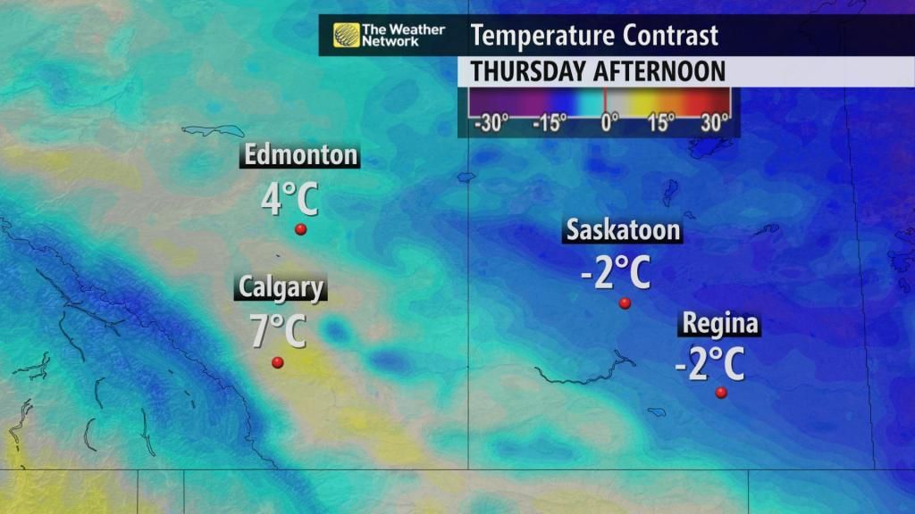
Western Canada
- Prairies: A milder airmass will move in Thursday, ushering in warmer temperatures. After a frigid day in Saskatchewan on Wednesday, near seasonal temperatures come as a welcome relief on Thursday. Highs in Alberta could climb to the double-digits by the weekend, although there is a risk of freezing rain and mixed precipitation for areas around Edmonton and east of the city in the pre-dawn hours Friday.
- British Columbia: Rain through the north and central coasts on Thursday, where up to 60 mm is expected. Meanwhile, fair and warm across the south. "B.C. is looking at beautiful temperatures over the next seven days," Vettese says. "There's a slight risk of a shower Thursday but there will generally be a mix of sun and cloud for the remainder of the week."
- West coast Spring Outlook: B.C. is ahead of the pack in Canada, having experienced spring-like weather already in the latter half of winter. Expect March, however to be close to seasonal in temperature. After a cold few days to start the month in the Prairies, a period of spring-like temperatures is expected through the second week of March. The mild temperatures will not be here to stay.