Big Christmas warm-up for many Canadian cities
Digital Reporter
Sunday, December 21, 2014, 11:46 AM - Well, there's good news and bad news for Christmas in Canada.
We've already been covering the bad news: A system that could bring some windy, messy weather to Ontario, Quebec and the Maritimes later this week.
We'll have the latest for you in the lead-up to Christmas as the system evolves, but we do have some good news: Temperatures in most provinces are set to rise nicely above seasonal - in some cities, flirting with double-digit highs.
Rain & mild Christmas Eve, HI 10C; Very windy w/ wet snow showers Christmas; Pattern change after Dec 27 - much colder heading into New Year
— Doug Gillham (@gtaweather1) December 21, 2014
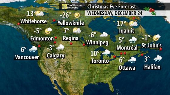
Christmas Eve will be the toastiest for Ontario and Quebec (comparatively speaking). Toronto is looking at a high of 10oC on Wednesday, Ottawa hits 6oC, and Montreal will be 5oC, with all three cities 10 degrees or more above the seasonal average.
"Christmas Eve could be the mildiest December 24 since at least 1996, perhaps longer," Weather Network meteorologist Tyler Hamilton said Sunday. "Temperatures could even hit the low teens for Niagara and even warmer for portions of New York State."
The Prairies won't be so warm, but even they will be above seasonal. All major Prairie cities will be in the negative single digits.
Vancouver is actually on track to hit 9oC on Sunday, but Hamilton says temperatures are trending cooler on the South Coast, with a slow drop back to seasonal by Christmas Day.
And when it comes to above seasonal temperatures, it's Atlantic Canada that hits the jackpot on Christmas Day.
Planning on travelling somewhere warm? Feel free to cancel: Temps 10-12°C + forecast for Christmas Day #ATLweather pic.twitter.com/CzBfWfOZLE
— 50 Shades of Van (@50ShadesofVan) December 21, 2014
"The warmest temperatures will be on a line from Yarmouth, Saint John and Fredericton on Christmas Day, with temperatures in the 10-15oC range," Hamilton says.
"Fredericton has a real shot at breaking two all-time daily records for December 25: It's likely to have the wettest Christmas on rain, more than the 34.9 mm it received on Christmas Day in 1978, while the temperature record of 12oC in 2003 will be a little harder to break."

Enjoy it while it lasts: A post-Christmas cooling trend will pull temperatures back down to around seasonal heading up to the new year.
![]() TUNE IN: We'll have ongoing coverage of active weather in your area on The Weather Network on TV.
TUNE IN: We'll have ongoing coverage of active weather in your area on The Weather Network on TV.


