Atlantic hurricane season to see rise in number of storms
Meteorologist, PhD
Tuesday, July 19, 2016, 10:28 AM - As summer progresses, some areas of the Atlantic Ocean continue to warm well above what we would be expecting for this time of year.
Considerable warmer sea surface temperature (SST) anomalies are now found off the coast of the northeast U.S. and all of eastern Canada. Waters off the coast of the southeastern U.S., the Caribbean Sea and the Gulf of Mexico also show positive SST anomalies, but not as large the north.
![]() RELATED: Record start to hurricane season says little about future
RELATED: Record start to hurricane season says little about future
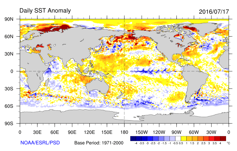
This warming water far from the breeding grounds of many hurricanes that move into the U.S. from the south and east could mean more activity than anticipated in the coming months. August, September and some years October are the most active months in terms of hurricane activity in the Atlantic, and as waters warm, other atmospheric conditions being favourable, the potential energy for these storms to form grows significantly.
Updated seasonal forecast slightly increase the number of storms
Seasonal forecasts have been stepped-up a notch since Spring. The Tropical Meteorology team at Colorado State University predicted 13 named storms in their April forecast, but have now updated it to 15 storms in their latest July revision. As originally predicted, they are still holding that six of those storms will become hurricanes and two could be major ones. This forecast shows a slight increase in activity with respect to those published by other research teams like for example NOAA, mainly because of a weak La Niña and a cool north Atlantic SST pattern.

Based on the latest CSU data, the U.S. has a 50 per cent probability of at least seeing one major hurricane (category 3-4-5) making landfall along the entire coastline (average for the last century 52 per cent), while the value decreases to 30 per cent for the East Coast (average for the last century 31 per cent).
Key elements for this 2016 Atlantic hurricane season
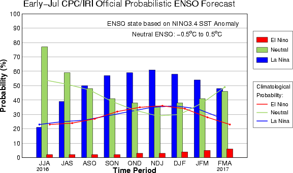
The main driving elements for hurricane formation in the Atlantic are the SST values present in the Atlantic itself, the predicted wind shear conditions in the region, and the SST pattern found in the Pacific related to the timing of the transition from El Niño to La Niña in the equatorial Pacific Ocean. Model predictions anticipate that the second part of this 2016 season will be more active as La Niña intensifies in the Pacific and becomes one of the main drivers of activity for the Atlantic.
Forecasts also tend to favour storm formation closer to the U.S. coastline because of warmer SST and weaker wind shear than what is expected in the eastern tropical Atlantic where they are more likely to develop. With storms having less travel distance and momentum, we could see more U.S. bound storms due to warmer waters nearby, but weaker overall. However, nothing can be ruled out.

Beyond SSTs, wind shear is a dominant factor in hurricane development and intensification. During the 2015 season, dry air and unfavourable wind shear conditions related to a strong El Niño in the Pacific, helped suppress hurricane activity in the Atlantic. However, other years where El Niño has not been present have also been marked by unfavourable atmospheric dynamics and a diluted Atlantic hurricane season as in 2013.
Will the warm blob in the Pacific return?
Aside from how the strength and timing of La Niña during the summer and early Fall will affect the Atlantic hurricane season, SST anomalies in other areas of the Pacific also have to be taken into account. Summer and Fall of 2015 were not only marked by a strong El Niño in the equatorial Pacific, but also by what was referred to as "The Blob," a large pool of warmer than usual water sitting off the coast of North and Central America.

This summer, the Eastern North Pacific is already showing a positive SST anomaly pattern and model predictions indicate that by September, it could intensify further with values ranging anywhere from 3 to 4oF off the coast of Alaska and Canada.
Although this is a different ocean-atmosphere interaction signal to keep an eye on, the warmer waters in the north Pacific will probably have an effect on the nature of the Pacific Northwest storms moving into the region later this Fall. However, the warmer SST anomalies to the south, off the west coast of Mexico and Central America, could have a weakening effect on hurricane development and intensification in the Atlantic Ocean basin in the coming months.