Amplified Flow Turns Up the Volume on Active Weather
Meteorologist
Thursday, December 11, 2014, 9:51 AM -
"Active" is the word that best describes the current weather pattern across Canada. Whether you're getting drenched in Vancouver, bracing for a snowy commute in Toronto, or enjoying unseasonably mild temperatures in Calgary, there is one common element to your weather story: it is far from average. And you have Amplified Flow to thank.
When things are calm and the atmosphere is being well-behaved, winds in the upper atmosphere tend to flow reliably from west to east in the belt known as the Mid-Latitudes (between 30 and 60 degrees north of the equator). This is the pattern we call "Zonal Flow", and it results in quiet, seasonal, and from a Meteorologist's perspective boring weather. Airmasses stay politely in place, with cold air bottled up in the north, and warm air confined to the south. Storminess is at a minimum, and there are no unruly fronts racing around the weather map causing trouble. But Zonal Flow doesn't tend to last for long, especially at this time of year.
The atmosphere has a job to do, and that job is to balance earth's energy budget. Because of the tilt of the earth's axis, the tropical regions are always receiving more energy from the sun than they can use, while the poles never get quite enough. The atmosphere is the engine that moves that energy around, in the form of heat, from the too-warm tropics to the too-cold poles. All that energy moving around is what drives the weather that we experience.
If the atmosphere needs to move energy from the tropics to the poles, it isn't going to get far with placid, west-to-east Zonal Flow. And so as a result a pattern develops which we call "Meridional Flow" or "Amplified Flow". The more amplified the flow, the more north-south component there is to the Mid-Latitude winds aloft, and the more active the weather becomes.
These current weather charts are an excellent example of Amplified Flow, and the impact that it has on the weather that we experience.
The first chart shows the atmosphere at about 5500 meters above the surface, high enough aloft that we can see the "big picture" of the atmospheric flow pattern. Far to the north and far to the south, we can see some regions of Zonal Flow. Notice how orderly the contours are here, and how the small blue wind barbs march more or less perfectly in step from west to east.
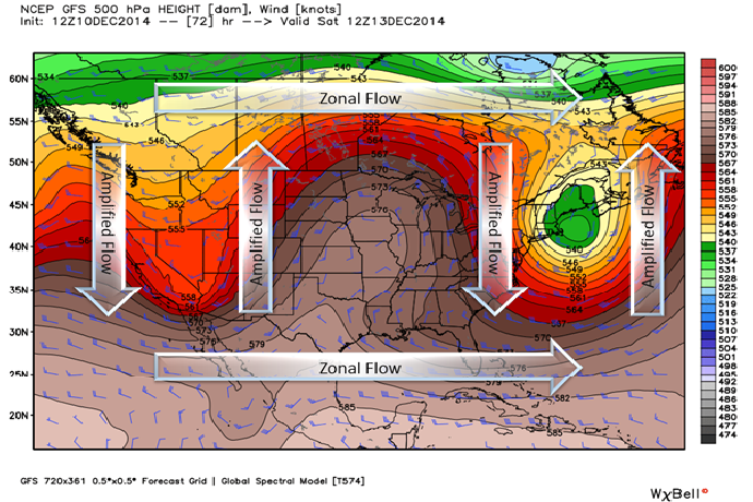
Now take a look at the region in the middle of the map where things get a bit more interesting. The flow deflects wildly to the north and south, like winding mountain road. These areas of north-to-south or south-to-north flow indicate regions where the atmosphere is moving heat energy around, and they will become the focus for active weather, as the other charts show.
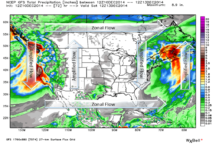
The next image below shows forecast precipitation amounts for Wednesday through Saturday morning. Powerful storms are bringing heavy rain and snow to both the East and West Coasts, while the Interior will remain remarkably dry, with little precipitation over the next few days. These are both sides of the same Amplified Flow coin, and the more exaggerated the pattern, the more distinct the contrast will be between wet and dry.
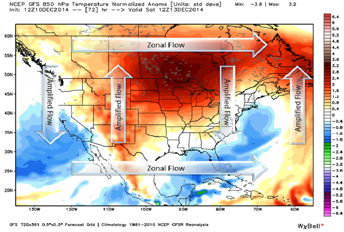
The final chart shows the temperature characteristics of the airmasses over North America. This illustrates how well Amplified Flow does its job of moving energy around the earth's surface. The southward components of the flow are driving cool air towards the tropics, both off the coast of California and down the Atlantic Seaboard of the US. Meanwhile the northward components are bringing warm air into the Prairies and Northwestern Ontario, as well as into Atlantic Canada.
Warm or cold, wet or dry, one thing is for sure. When Amplified Flow is in the forecast, interesting weather is sure to follow.


