Alberta snowfall warnings expanded again
Digital Reporter
Tuesday, September 9, 2014, 5:55 PM -
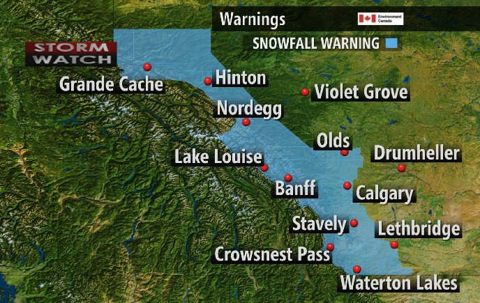
On Tuesday afternoon Environment Canada expanded its snowfall warnings in Alberta to include the Lethbridge and Nordegg regions.
Environment Canada is calling the wintry weather the 'first significant snowfall of the season,' with multiple communities -- including the City of Calgary -- waking up to a fresh coating of snow.
![]() STORM WATCH: Margeaux Morin will be live from the region beginning 7 a.m. MDT. Tune in and, if it's safe to do so, upload your pictures and videos here.
STORM WATCH: Margeaux Morin will be live from the region beginning 7 a.m. MDT. Tune in and, if it's safe to do so, upload your pictures and videos here.
"The City of Calgary could receive an additional 10-15 cm, with the foothills seeing 15-25 centimetres," says Weather Network meteorologist Dayna Vettese.
"Areas around Waterton Lakes could see closer to 35 cm in the higher elevations."
Precipitation is expected to last into Wednesday morning.
![]() TUNE IN: Watch the Weather Network on TV for updates on these storms. If it's safe to do so, upload your pictures and videos here.
TUNE IN: Watch the Weather Network on TV for updates on these storms. If it's safe to do so, upload your pictures and videos here.
"As the Arctic high pressure system sags south, it funnels modified Arctic air into southern Alberta, as Calgary struggles to reach plus 3oC on Wednesday," explains Weather Network meteorologist Tyler Hamilton.
Fortunately for some, the winter-like conditions will be short-lived.
"We're expecting a return to near-normal temperatures for the weekend," Vettese says.