A look ahead at the weekend across Canada
Meteorologist
Friday, August 15, 2014, 9:06 AM -
This summer has been plagued with cold snaps, mainly for the eastern half of the country, which can be attributed to an amplified jet stream.
The big cold snap from earlier this summer during July was first attributed with Typhoon Neoguri which affected Japan. As the typhoon recurved northward it interact with the jet stream causing it to, in simple terms, amplify, inducing large ridge pattern in western Canada and a deep trough in the east resulting in the aforementioned cold spell.
This latest cold snap could be attributed to the active western Pacific in terms of typhoon activity which would amplify the East Asian jet stream resulting in a pattern described above. I also suspect that the abnormally mild eastern Pacific can also cause as similar pattern within the jet stream as well. But the real question here is whether this pattern will linger for the upcoming weekend. Well, the outlook is pretty well divided from east and west.


Québec and Atlantic Canada
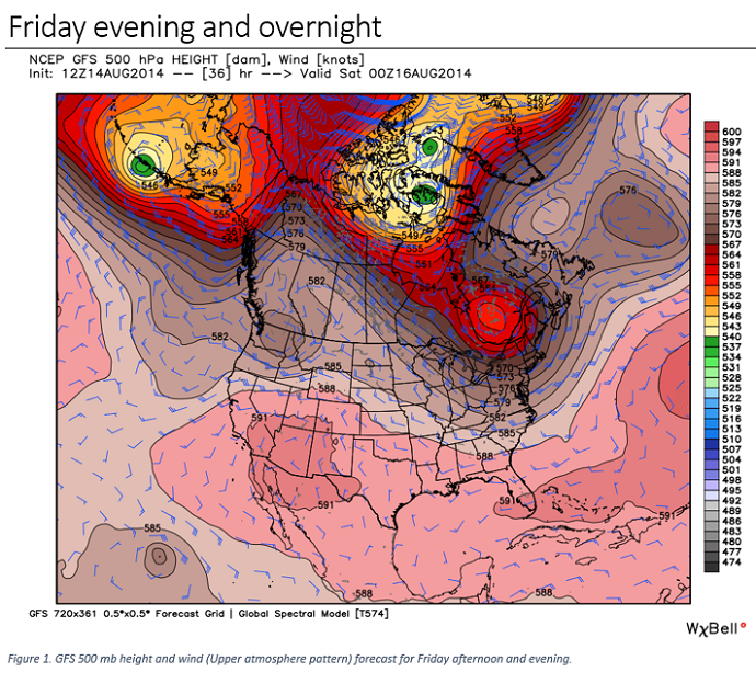
The large upper low currently affecting eastern Canada is not forecast to track very far come Friday and is likely to be centered in central Quebec as shown in Figure 1. Figure 2 shows the resulting temperature anomalies from the upper low in place. Keep in mind this does not show actual temperature just the departure from seasonal values. Thus we can see the upper low will continue to keep southern Quebec in below seasonal temperatures, which will also begin to push into New Brunswick. The northern periphery of the upper low into northern Quebec and Labrador will swing in milder air which will keep these areas near or above seasonal. The cool anomaly through the Avalon and eastern Newfoundland will be attributed to a persistent and vigorous north-easterly flow off the cool Atlantic and not so much associated with the upper low. Precipitation wise, the surface frontal boundary out ahead of the upper low will continue to push showers through Nova Scotia and Cape Breton while the central core and southern periphery of the upper low will continue to fuel widely scattered yet isolated showers (popcorn like showers) through much of Quebec as seen in Figure 3.
![]() SEE YOURSELF ON TELEVISION!: Every hour at :02, :12, :22, :32, :42 and :52 we feature the best viewer-submitted photos. Send us your weekend pictures ... you might just see them on air! | UPLOAD HERE
SEE YOURSELF ON TELEVISION!: Every hour at :02, :12, :22, :32, :42 and :52 we feature the best viewer-submitted photos. Send us your weekend pictures ... you might just see them on air! | UPLOAD HERE
Ontario
Not much to be said for Friday evening as the most of central and southern Ontario will remain dry. The only real issue is temperatures which will continue to be below seasonal across the province, although not as cold as Thursday as shown in Figure 2 thanks to the upper low that will slowly push northward as shown in Figure 1. The warmer anomaly shown through northwestern Ontario will be due to modest southwesterly flow ahead of a frontal boundary. This will result in unsettled conditions with showers and thunderstorms through Friday afternoon and evening.
Western Canada (Manitoba to B.C.)
The upper low currently affecting B.C. and Alberta will stay nearly stationary Friday afternoon sitting on the B.C. and U.S. border (see Figure 1). Other than some slightly cooler temperatures across southern Alberta and through the B.C. interior, no real changes are expected to the current pattern. The stronger upper ridge through Yukon and Northwest Territories will drive temperatures well above seasonal through northern B.C. and Alberta which will trickle across Manitoba and Ssaskatchewan. The precipitation forecast in Figure 3, however, appears worse than what it shows. With this type of setup, expect to have scattered showers and thunderstorms through much of the afternoon. Not a total wash out but some rainmaking thunderstorms are likely. The one exception to this will be within the Foothills where some steadier rainfall is possible.
NEXT PAGE: SATURDAY'S OUTLOOK


