Northern Tornadoes Project seeks every twister in Canada
Ambitious plan aims to capture every tornado in Canada in 2019
Canada's Northern Tornadoes Project (NTP) is setting an impressive goal for 2019's tornado season: Find every tornado that touches down across the country.
Visit our Complete Guide to Spring 2019 for an in depth look at the Spring Forecast, tips to plan for it and much more
A BIG GOAL FOR A BIG COUNTRY
The project is a partnership between engineers at Western University and Environment and Climate Change Canada (ECCC), and has, for the last two years, focused on sniffing out previously-undetected tornadoes in Quebec and Ontario. This year, the program is going national, with the goal to capture Canada's 'missing tornadoes'.
"The goal is to capture everything nationally," engineering professor Greg Kopp, one of the project's leaders, told Western News. "To find, assess, store data and learn from each event. It’s a big goal and it’s a big country.”
Currently, about 60 tornadoes are identified in Canada every year. ECCC studies suggest the total number should be closer to 200, with those occurring in non-urban areas being, as one might expect, harder to confirm.
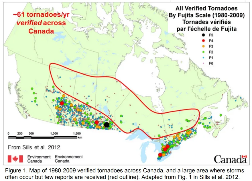
Image courtesy AMS/Sills et al.
SEEING THE FINE DETAILS
The NTP uses a suite of technologies to identify their potential targets, including radar to track likely tornadic storms, ultra high-resolution satellite to determine potential damage paths on the ground, and then in-person surveys, drones, and crowd-sourced photos and reports to confirm a 'hit'.
With today's high resolution satellites, it's possible to determine disturbances on the ground to within two to three metres, Kopp told the London Free Press. Plane surveys can get detail down to within five centimetres.
CAN YOU CATCH THEM ALL?
Ambitious as it sounds to want to capture every twister across the country, the project has seen excellent results in its two years of operation, detecting or improving data for 18 tornadoes in 2017 -- including a major outbreak in Quebec in June -- and 22 in 2018, including a survey of the EF-4 tornado that struck Alonsa, Manitoba.
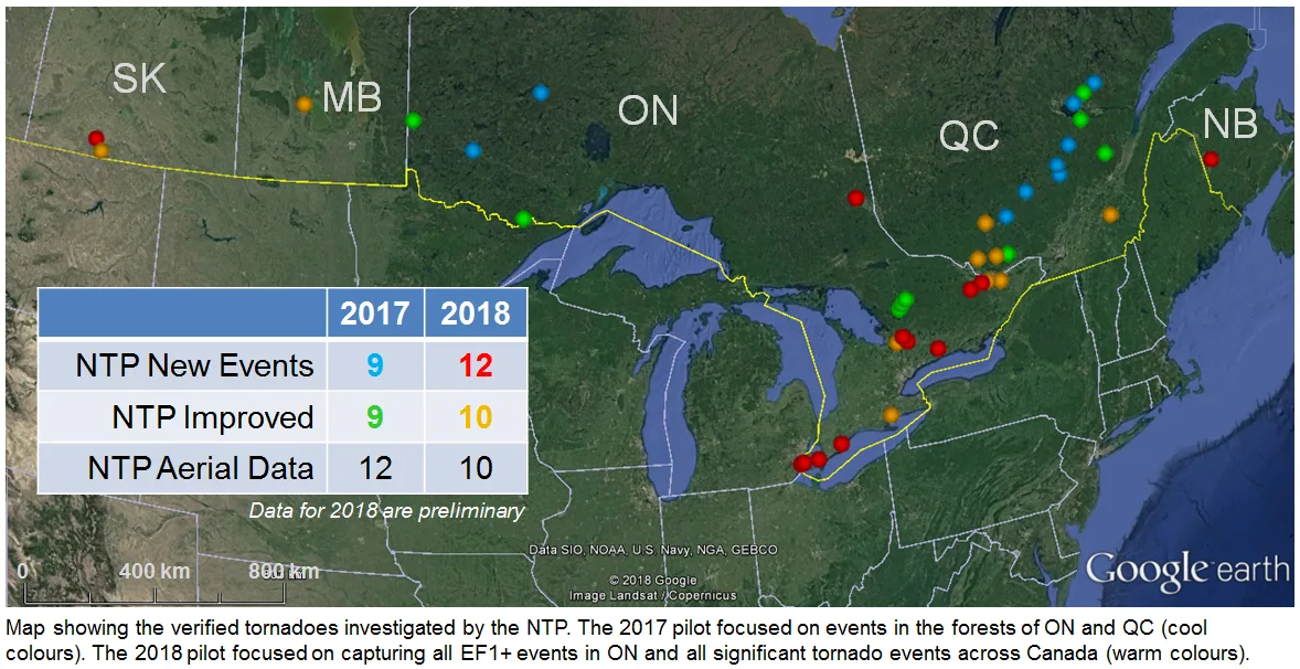
Image courtesy UWO Media Relations
"I’m hoping for at least a 50 per cent increase," says Dr. David Sills, the ECCC lead researcher on the project. "I think that [50 per cent] is realistic."
One of the challenges of moving out of the relatively-forested areas of Ontario and Quebec and into other tornado-prone areas like the Prairies is the shift from looking for damaged trees to open grassland.
"Our current methods work better with forests rather than fields," says Sills, "but we showed with the Alonsa EF-4 tornado last year that satellite can reveal the track." Sills adds that the group is working with an international teama of experts to refine their detection method for smaller tornadoes in open areas.
A SHIFT IN TORNADO ALLEY?
The 2017 tornado outbreak in Quebec uncovered by the group proved to be not only the biggest in the province's history, but one of the biggest (now) on record in Canada. If the number of tornadoes across Canada does prove to be in line with models -- in excess of 200, rather than the current average of 60 -- that raises the question: Are Canada's most tornado-prone areas really where we think they are?
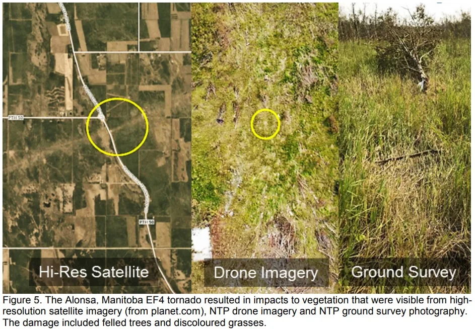
Image courtesy AMS/Sills et al.
Canada's 'Tornado Alleys' are generally thought of as stretching across southwestern Ontario, and then across the Prairies from the foothills to southern Manitoba. But the new data the NTP is unearthing may force us to adjust our thinking.
"We are beginning to see a more true picture of tornado occurrence in Canada, not necessarily focused along urbanized corridors," says Sills. "One 'hot spot' that certainly seems to be slowly revealing itself is southern Quebec and eastern Ontario."
In addition to attempting to reveal every 2019 twister in Canada, the group also plans to develop a publicly accessible digital archive of their findings, and is researching ways to automate the detection of storm damage paths that are visible in high-resolution satellite data.
Sources: Western News | AMS | London Free Press |