A rare behemoth: Hurricane Lee’s incredible 9,000+ km journey
Most thunderstorms only last a couple of minutes before they rain themselves out. A few thunderstorms manage to survive for a couple of hours, rolling across the horizon as a formidable torrent.
Visit The Weather Network's hurricane hub to keep up with the latest on tropical developments in Canada and around the world
But a tiny fraction of thunderstorms grow into something bigger than themselves over the course of several weeks, managing to swirl into the history books among the rarest storms recorded in modern history.
Hurricane Lee defied the odds to become one of those top-tier storms. Originally starting as a cluster of thunderstorms in sub-Saharan Africa, within three days Lee morphed from a mere tropical depression into a monstrous Category 5 storm.
Lee’s journey to Canada began two weeks and 9,000+ km away
Lee began like many peak-season hurricanes in the tropical Atlantic Ocean. Monsoon season over sub-Saharan Africa is ripe for thunderstorms to roll across the continent and over the eastern portion of the ocean.
PHOTOS: Thousands left in the dark in the Maritimes after Lee's wrath
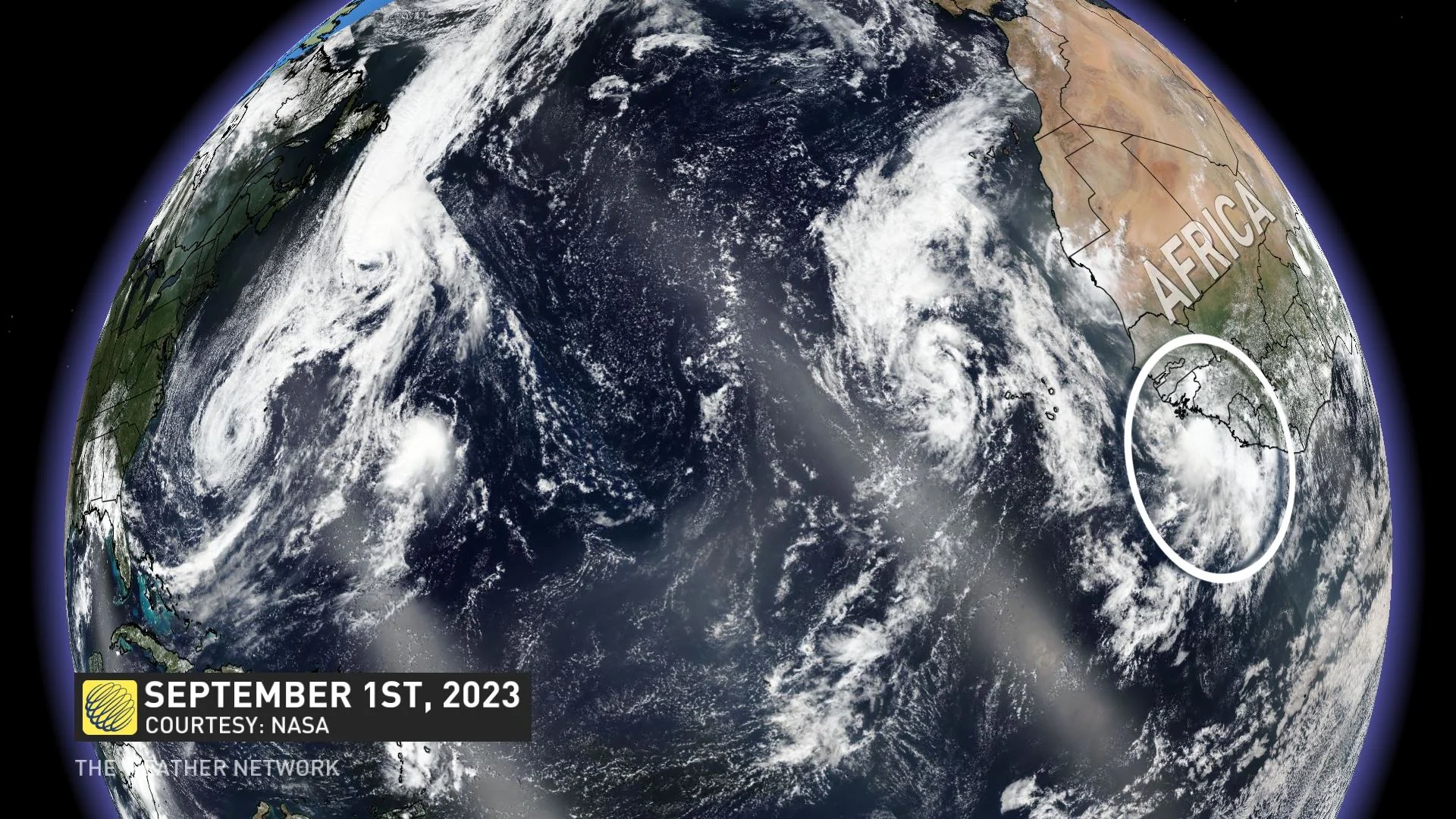
If these clusters of thunderstorms find warm waters, low wind shear, and ample moisture, this tropical wave can quickly seed the development of a tropical depression.
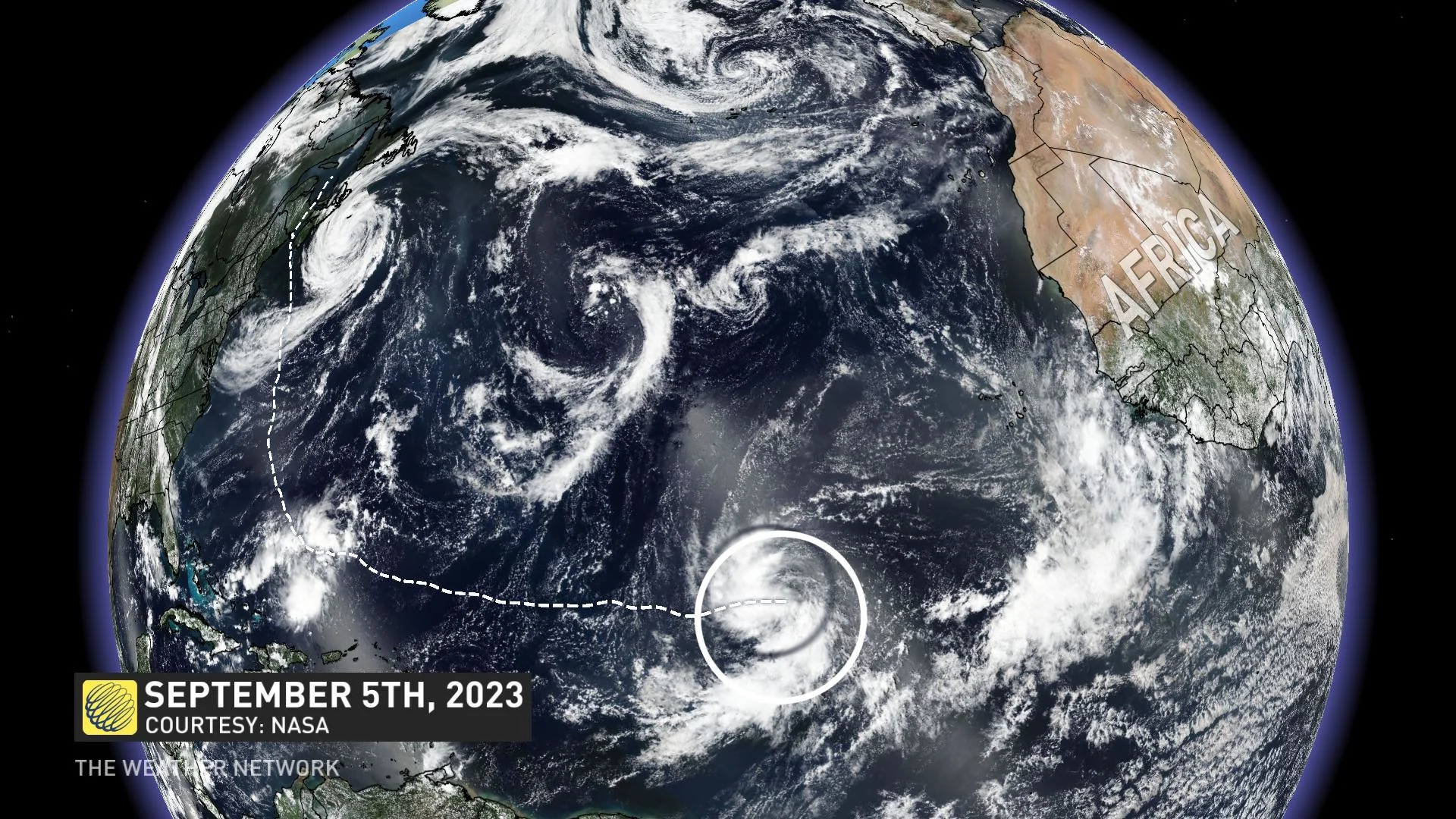
Tropical Depression Thirteen formed on Sept. 5 as the unstable air feeding into those thunderstorms pulled air away from the surface, leaving less air—and lower air pressure—above the ocean.
DON'T MISS: How hot water fuels the world’s most powerful hurricanes
This newly formed low-pressure centre rapidly organized under very favourable conditions, growing into Tropical Storm Lee within just six hours of first becoming a depression.
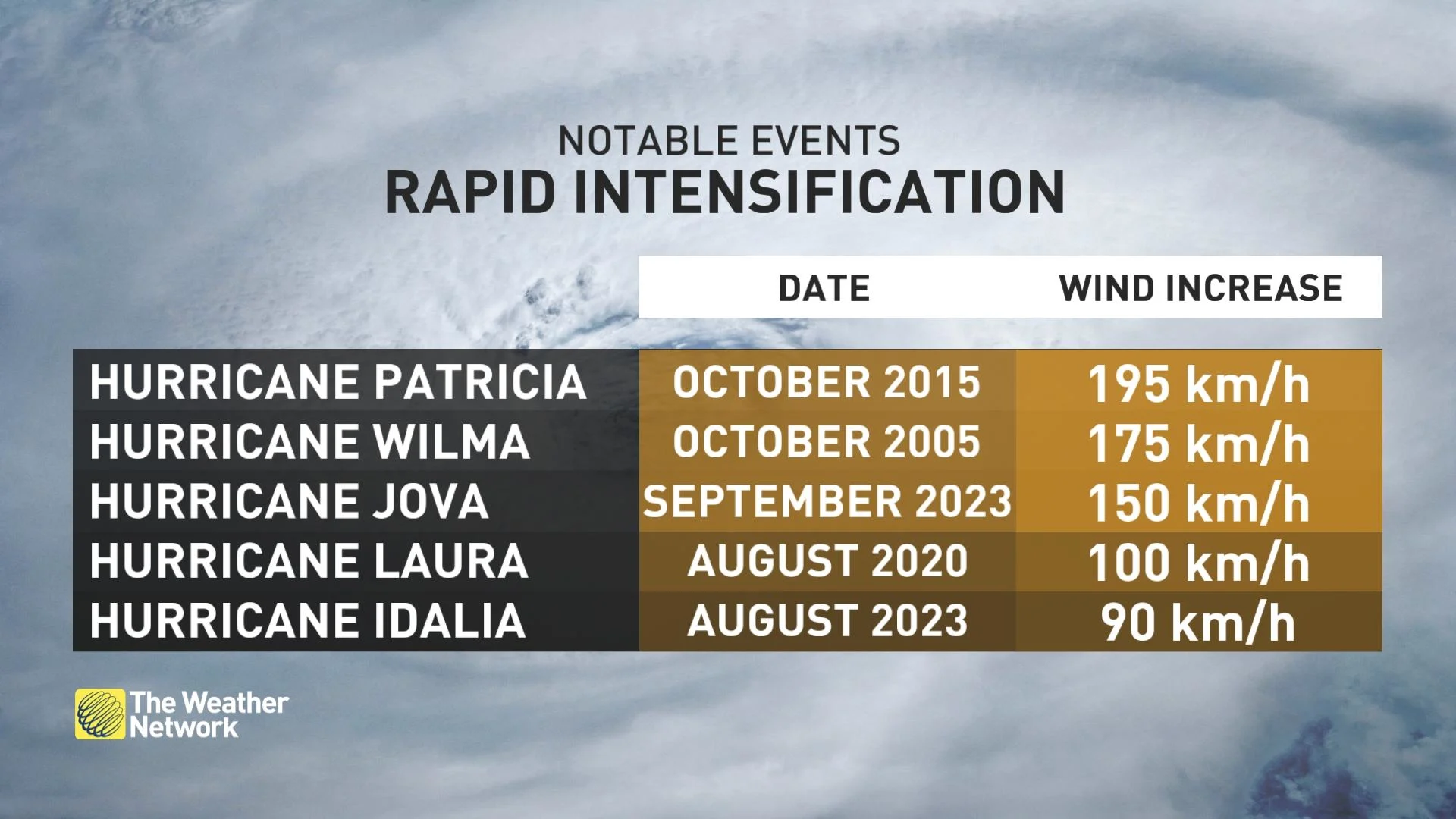
Things got serious in a hurry. Every once and a while, under perfect conditions, a tropical system can take full advantage of the environment around it and undergo a period of rapid intensification.
Rapid intensification occurs when a storm’s maximum sustained winds jump at least 55 km/h in a 24-hour period. That may not seem like much, but it can mean the difference between a Category 1 hurricane and a Category 3 hurricane over the span of a single day.
WATCH: 2023 has seen a category 5 hurricane in every corner of the tropics
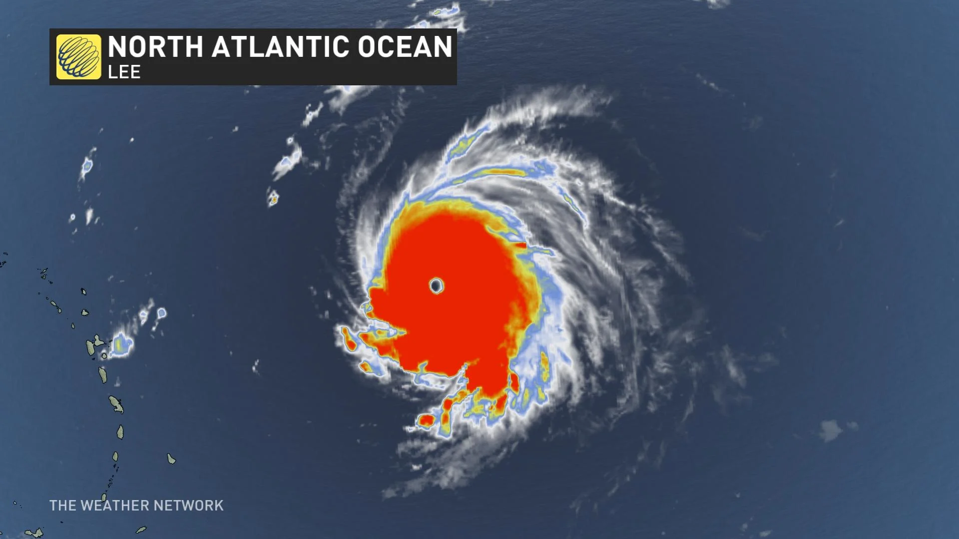
Lee becomes a rare Category 5 hurricane
Within 24 hours of Tropical Storm Lee’s inception, on September 6, its winds quickly climbed from 75 km/h to 120 km/h, a 45 km/h increase, earning the storm the new title of Hurricane Lee. While this sudden jump fell just short of being classified as rapid intensification, Lee was only just getting started.
Hurricane Lee had grown into a Category 2 storm by the afternoon of September 7, with forecasters becoming confident that it would quickly reach major hurricane status. By that same evening, Lee’s winds had rapidly intensified to Category 4 strength.
DON'T MISS: How a mammoth hurricane rapidly intensifies in mere hours
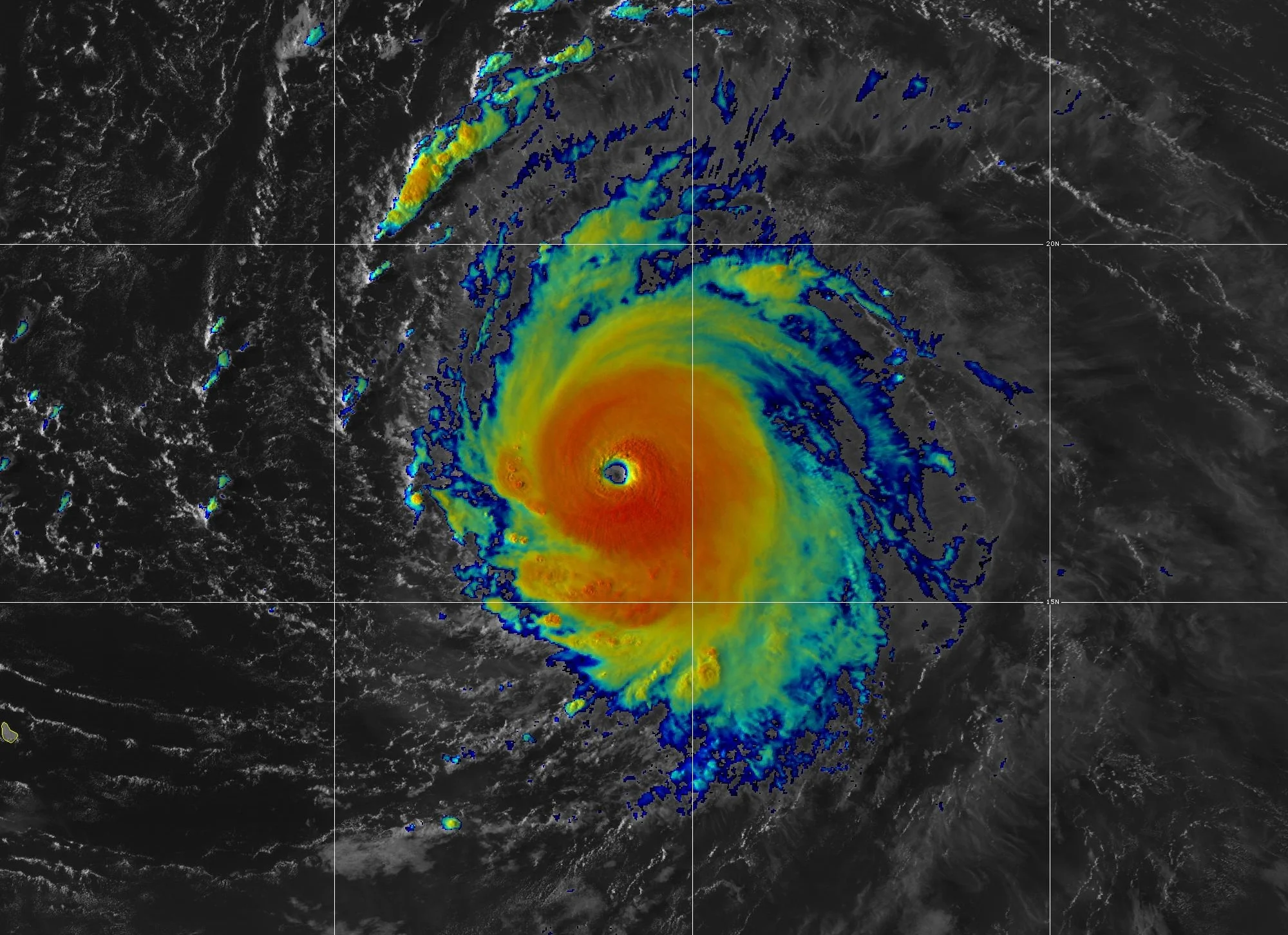
Later that night, and 30 hours after it first grew into a hurricane, Hurricane Lee became a scale-topping Category 5 storm with maximum sustained winds of 260 km/h. Its winds jumped 95 km/h in just 12 hours, and by an astounding 130 km/h over the course of just 24 hours, making it a top-tier storm in terms of rapid intensification in the modern era.
Lee further intensified to its apex with 270 km/h winds by 5:00 a.m. on Friday, September 8.
RELATED: A world first, every tropical ocean saw a Category 5 storm in 2023
This remarkable intensification made Hurricane Lee only the 29th Category 5 hurricane ever recorded in the Atlantic Ocean since the satellite era began back in 1960, and the eighth scale-topping storm to churn through the Atlantic in the past decade alone.
Thankfully, Lee’s peak strength didn’t last very long. A little bit of wind shear and dry air knocked the storm off-balance, quickly forcing the storm to lose some of its pristine structure and weaken over the following two days as it passed far north of the Caribbean Sea.
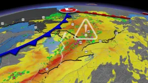
A large Lee eyes Canada
A trough dipping over eastern North America began to steer Lee toward the north—directly toward the Canadian Maritimes.
Warm waters over the western Atlantic allowed Lee to regain some of its former strength, bringing the storm back to major hurricane status on Sunday, September 10, a status it would maintain as it passed west of Bermuda over the next couple of days.
RELATED: Saharan dust can make or break a monstrous Atlantic hurricane
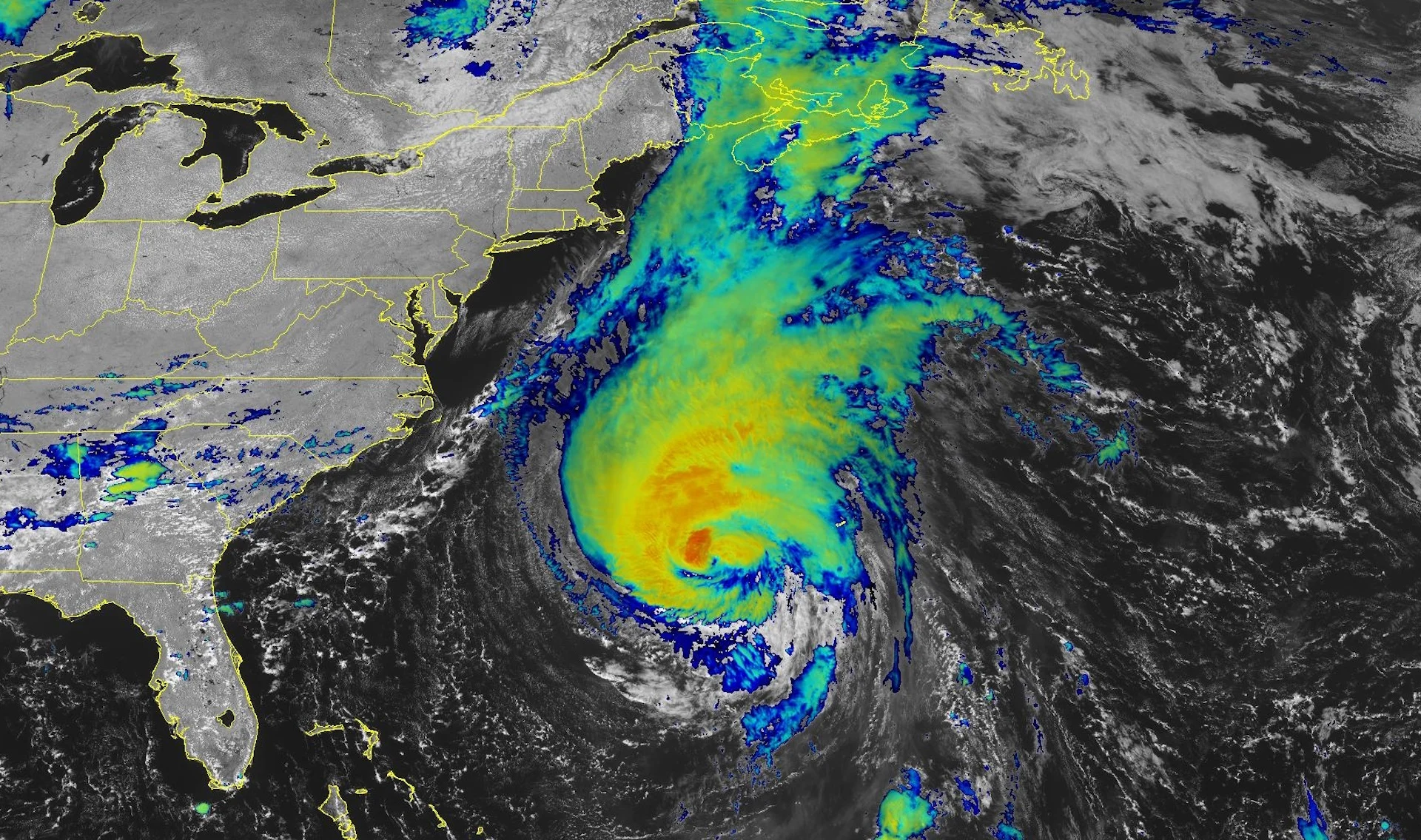
At this point all eyes were on Hurricane Lee’s path along the Atlantic coast, and how it would impact New England and Atlantic Canada. Several scenarios were in play for how Lee could progress as it moved northward. However, which track would come to fruition couldn’t be determined until closer to its landfall.
Hurricane Lee on September 14, 2023. (NOAA)
By the afternoon of Wednesday, September 13, Lee was still maintaining a Category 3 strength – making forecasters and East Coast residents sweat. At this point, too, it was becoming clearer that New England and Atlantic Canada were going to face the impacts of this mighty storm.
Luckily, by Wednesday evening Lee had weakened into a Category 2 storm, and by Thursday afternoon it weakened even further to Category 1. Environment and Climate Change Canada issued hurricane watches and tropical storm warnings for the Maritimes, alerting residents to prepare for the storm’s arrival on September 16.
WATCH: Storm anxiety high among Nova Scotians after a harsh year
160,000+ lose power as Lee hit the Maritimes
Hurricane Lee began to lose its tropical characteristics as it approached Atlantic Canada, transitioning from a hurricane into a storm more closely resembling a nor’easter.
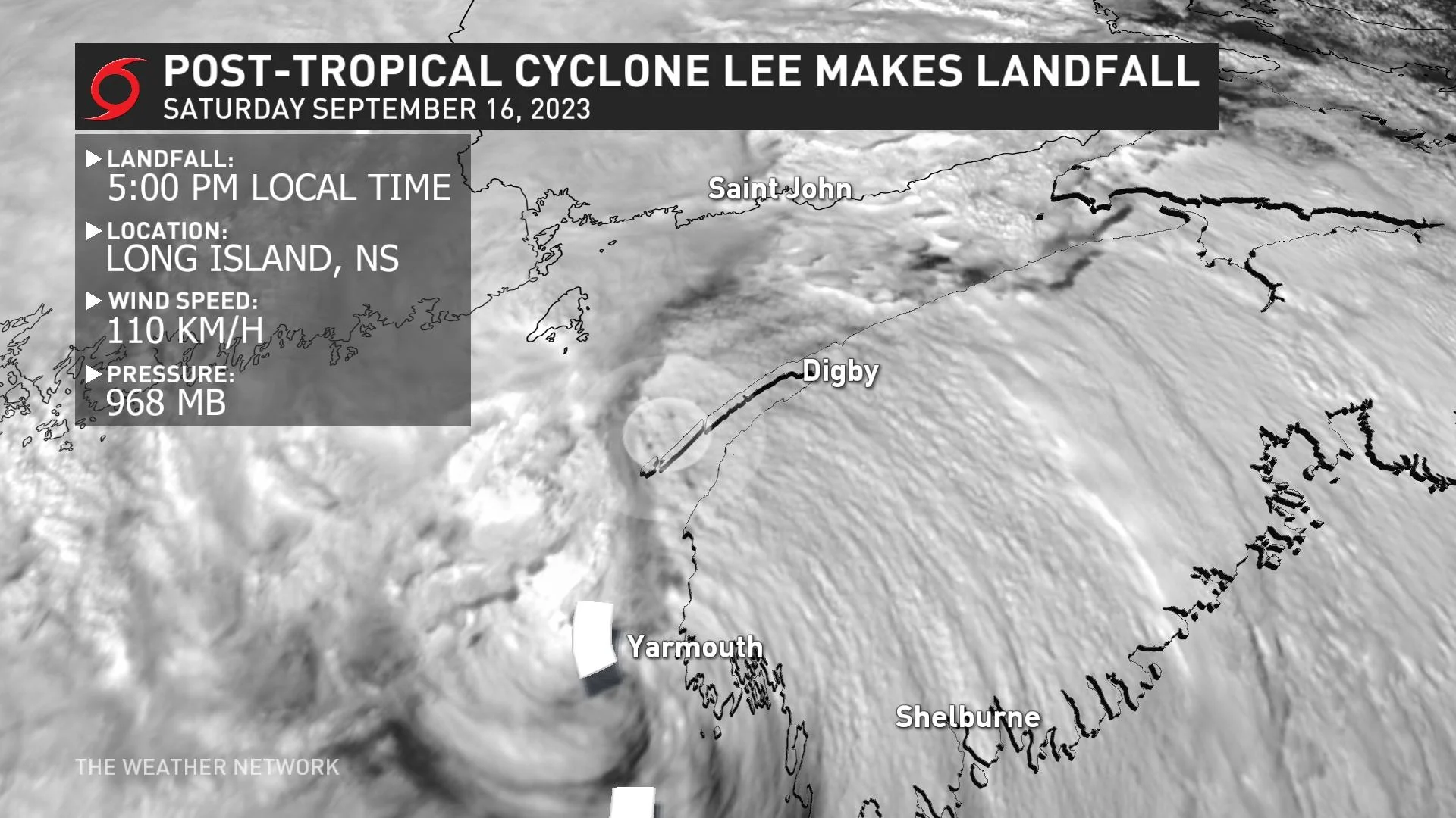
This transition also helped the storm massively expand its wind field, with tropical storm-force winds stretching more than 550 km from the eye at its largest, the whole storm measuring more than 1,000 km from end to end by the time it reached Nova Scotia.
During the early hours of Saturday, September 16, Lee arrived over the Maritimes as a post-tropical storm, later making its official Canadian landfall at 5:00 p.m. local time.
The long-anticipated storm caused widespread impacts across the provinces. Lee’s ferocious winds knocked down trees and power lines throughout the region, severing power to hundreds of thousands of homes across Nova Scotia, New Brunswick, and Prince Edward Island.
Many roads were closed during and after the storm as a result of flooding from storm surge, rough surf, and heavy rains.
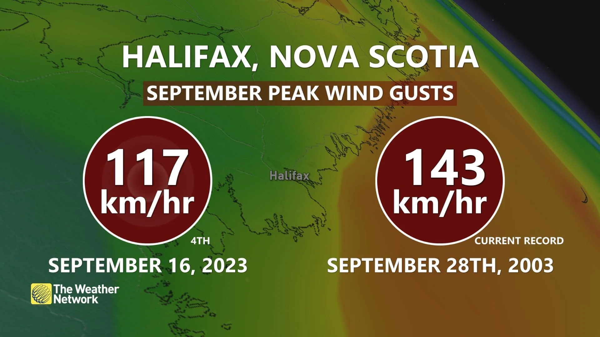
Halifax Airport saw a 117 km/h wind gust at Lee’s peak on September 16, with Halifax Harbour recording a storm surge of 0.72 m at high tide that morning. Immense waves churned the ocean just offshore, with buoys measuring 10+ m wave heights as the storm raked the region.
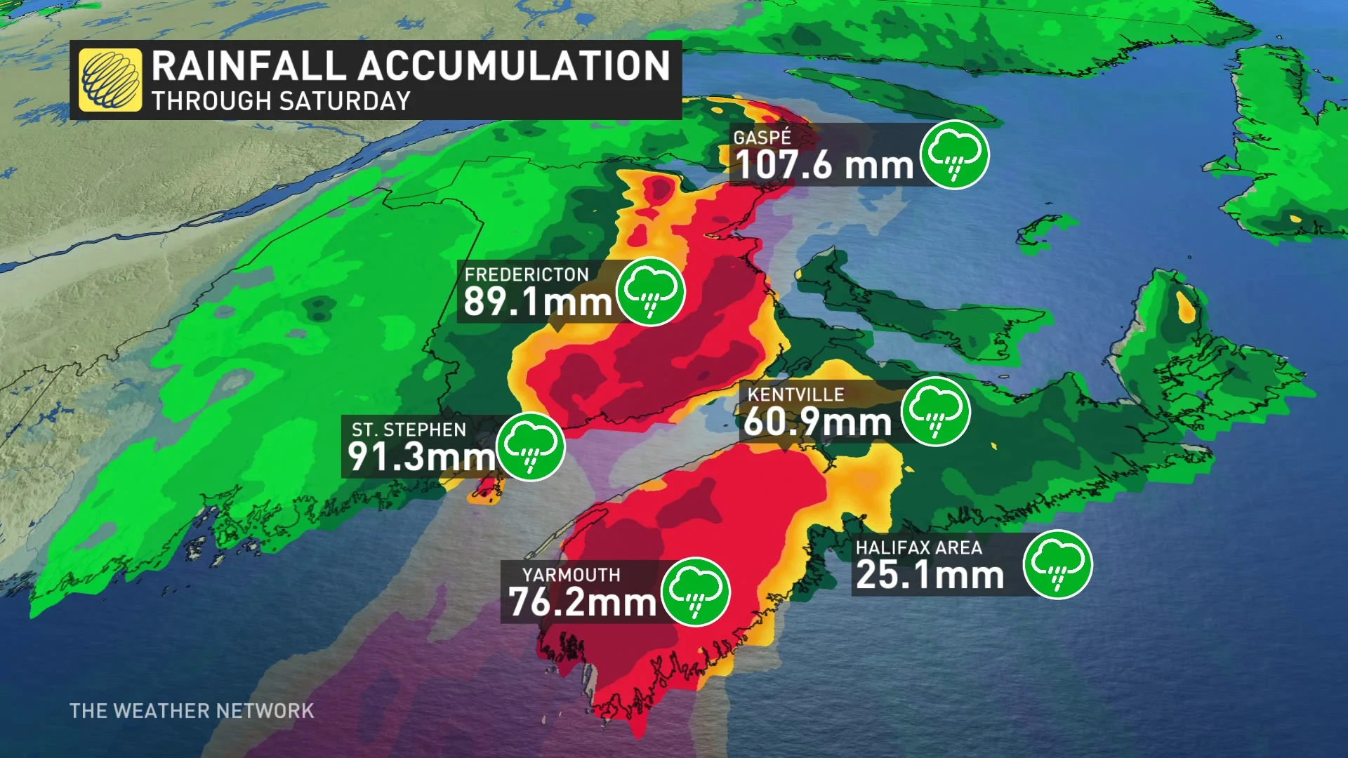
Widespread rainfall totals of 50-100 mm blanketed the Maritimes, padding the historic rains much of the region saw earlier this summer.
Lee pulled away from the region overnight Saturday into Sunday, September 17, unraveling as it swiftly departed to the north.
The hurricane’s 9,000+ km journey from sub-Saharan Africa to the Canadian Maritimes is one that’ll live forever in weather history for its ferocity and the sheer speed at which it achieved its frightening strength.
Header image courtesy of NOAA.