UPEI data analysis confirms Island suffered 'shocking' coastline loss from Fiona
The numbers are in for 2022, and Prince Edward Island lost a record amount of shoreline, according to researchers at UPEI's School of Climate Change and Adaptation.
The loss in some places was so extreme that the measuring pegs a coastal monitoring research project had been using for seven years were clawed away into the ocean.
The school's researchers have been monitoring 93 locations across P.E.I., including six new ones added along the western coast just last year.
Drone pilot Andy MacDonald said the 2022 monitoring results were on track to be average until late September. That's when post-tropical storm Fiona hit with all its fury.
SEE ALSO: Living shoreline provides living lesson for P.E.I. property owners, groups
"Everything that we flew afterwards, which was somewhere around a dozen or 15 sites, we noticed absolutely huge changes, especially on the North Shore and on the western coast of P.E.I.," MacDonald said.
"On the west coast, we visited about nine sites, all showing losses within about a metre and a half to seven metres. So [that's] very high for this study, where the average is usually around 30 or so centimetres a year."
The pilot said the results were "jarring," and the coastline losses in western P.E.I. were particularly striking.
"While the North Shore was in the news a lot, and a lot of areas got hit hard, I think it was a particular surprise going down the west coast and finding these huge losses," he said.

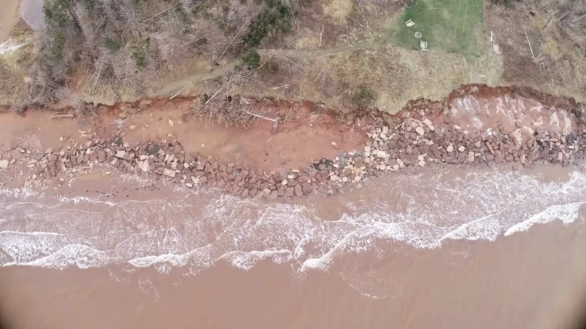
MacDonald said the team spoke to locals who said Fiona took out 10 to 12 metres of shoreline close to Cape Gage. (UPEI School of Climate Change and Adaptation)
MacDonald said the biggest shoreline loss was reported at Cape Gage Road, a new site added last year on the western coast of P.E.I. just north of Miminegash.
The monitoring data showed an average loss of seven metres, and MacDonald said some locals reported losing 10 to 12 metres of shoreline in nearby locations.
He said they also saw a loss of more than 25 metres in some areas of Miminegash Harbour, from "just the direction of the winds and the direction of the storm.
DON'T MISS: Why a 'tree's job isn't done' after a storm brings it down
"Obviously the water levels played a part as well," he said. "It was kind of a perfect storm, so to speak, for getting a lot of coastal erosion."
Catherine Kennedy is a masters student at the UPEI School of Climate Change and Adaptation, and has worked on peg-line coastal monitoring for the last five years.
The program uses two pegs placed perpendicular to the shore at each site, one 10 metres in and the second 10 metres back from it.
Kennedy said the damage after Fiona was so severe that some of the 200 monitoring pegs were lost — both pegs at some sites and just the seaward ones at others.
"It has been shocking. This past year has definitely been the highest amount of erosion that we've seen during our project. With the areas experiencing 10 and even 25 metres, it's certainly been a concern," she said.
Kennedy said the peg-line project is important to coastal monitoring because it gives researchers the opportunity to connect with the community when they travel around the Island.

Monitoring program team members place two pegs perpendicular to the shore at each site, one 10 metres from the coast and the other 10 metres back from the first peg. (UPEI School of Climate Change and Adaptation)
"The knowledge that people hold that have lived in this area for long periods of time is not something that we can calculate when using a drone," she said.
"We really like to be able to get out there and connect on the ground. So we think it's certainly still a valuable project going forward."
Restricting development
Kennedy said the coastal monitoring is also important for researchers looking for ways to protect the coastline from erosion.
"We need to consider where we're building, and potentially restricting development in some of these higher-hazard areas. And if people are considering building in coastal areas, they should request hazard assessments from the province so that they understand the risk that they're taking on," she said.
"I think the monitoring shows that we do have a vulnerability — and especially following Fiona, it's showing that we weren't incredibly resilient to those impacts," Kennedy said.
"I think the monitoring is going to help us show what areas are potentially more vulnerable, so that there is less development in those spaces."

A seven-metre shoreline loss was reported at Cape Gage Road, a new site added last year in western P.E.I. (UPEI School of Climate Change and Adaptation)
MacDonald said his group is talking to the province about the best way to cover as much coastline as possible, as they add about a dozen new locations in 2024.
He said they also encourage people to reach out to researchers if they are interested in joining the monitoring program.
This article, written by Nancy Russell, was originally published for CBC News.
Thumbnail image courtesy of UPEI School of Climate Change and Adaptation via CBC News.