Active Alerts Shanklerville, TX
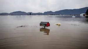
...The Flood Warning is extended for the following rivers inLouisiana...Calcasieu River Near OberlinCalcasieu River near White Oak Park...The Flood Warning continues for the following rivers in Texas...Louisiana...Neches River at Neches River Saltwater BarrierCalcasieu River Near GlenmoraSabine River Near BurkevilleSabine River Near Bon WierSabine River Near DeweyvilleAdditional information is available at www.weather.gov.The next statement will be issued Monday morning at 1100 AM CDT.* WHAT...Minor flooding is occurring and moderate flooding isforecast.* WHERE...Sabine River near Deweyville.* WHEN...Until further notice.* IMPACTS...At 26.0 feet, Moderate lowland flooding will occur. Thelowest homes between Deweyville and the river begin to flood,especially in the Indian Lakes and River Oaks sections. Low-lyingroads and a few homes in Southwestern Beauregard Parish have someflooding.* ADDITIONAL DETAILS...- At 9:45 AM CDT Sunday the stage was 25.6 feet.- Recent Activity...The maximum river stage in the 24 hoursending at 9:45 AM CDT Sunday was 25.6 feet.- Forecast...The river is expected to rise to 26.5 feetThursday morning. Additional rises are possible thereafter.- Flood stage is 24.0 feet.- http://www.weather.gov/safety/flood
...The Flood Warning is extended for the following rivers inLouisiana...Calcasieu River Near OberlinCalcasieu River near White Oak Park...The Flood Warning continues for the following rivers in Texas...Louisiana...Neches River at Neches River Saltwater BarrierCalcasieu River Near GlenmoraSabine River Near BurkevilleSabine River Near Bon WierSabine River Near DeweyvilleAdditional information is available at www.weather.gov.The next statement will be issued Monday morning at 1100 AM CDT.* WHAT...Moderate flooding is occurring and major flooding isforecast.* WHERE...Sabine River near Bon Wier.* WHEN...Until further notice.* IMPACTS...At 36.0 feet, Major lowland flooding will occur. SabineSands Road has about one to three feet of water covering the road.* ADDITIONAL DETAILS...- At 10:15 AM CDT Sunday the stage was 35.4 feet.- Recent Activity...The maximum river stage in the 24 hoursending at 10:15 AM CDT Sunday was 35.5 feet.- Forecast...The river is expected to rise to a crest of 36.0feet early Tuesday afternoon.- Flood stage is 30.0 feet.- http://www.weather.gov/safety/flood