Active Alerts Ojo de Angua, TX
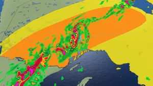
HLSCRPThis product covers South Texas**TROPICAL STORM WATCH NOW IN EFFECT FOR PORTIONS OF SOUTH TEXAS**NEW INFORMATION---------------* CHANGES TO WATCHES AND WARNINGS:- A Tropical Storm Watch has been issued for Aransas Islands,Calhoun Islands, Coastal Aransas, Coastal Calhoun, CoastalKleberg, Coastal Nueces, Coastal Refugio, Coastal San Patricio,Inland Calhoun, Inland Kleberg, Inland Nueces, Inland Refugio,Inland San Patricio, Kleberg Islands, and Nueces Islands* CURRENT WATCHES AND WARNINGS:- A Tropical Storm Watch is in effect for Aransas Islands,Calhoun Islands, Coastal Aransas, Coastal Calhoun, CoastalKleberg, Coastal Nueces, Coastal Refugio, Coastal San Patricio,Inland Calhoun, Inland Kleberg, Inland Nueces, Inland Refugio,Inland San Patricio, Kleberg Islands, and Nueces Islands* STORM INFORMATION:- About 570 miles south-southeast of Port Aransas TX or about 600miles south-southeast of Port Oconnor TX- 20.3N 93.2W- Storm Intensity 40 mph- Movement North-northwest or 345 degrees at 7 mphSITUATION OVERVIEW------------------A very large area of low pressure over the Bay of Campeche hasincreased its likelihood of development into a tropical system overthe next few days as it traverses the western Gulf. Therefore, theNational Hurricane Center has upgraded it to Potential TropicalCyclone One this afternoon.A Tropical Storm Watch is now in effect along all coastal countiesand marine zones from Baffin Bay through Port O'Connor. Regardlessof development and eventual landfall location, there are severalhazards and impacts expected across South Texas from tonight throughThursday due to the large extent of this system. The main threatswill be:- Flash Flooding: Moderate to high threat of flash flooding mainlyeast of I-37, especially in urban areas Tuesday through Thursday.Rainfall accumulations of 8-10" are expected along the Coastal Bendwith localized rainfall amounts up to 15". Across the rest of theregion, the Victoria Crossroads could see accumulations of 6-8"through Thursday, while the Brush Country could have amounts as highas 4-6".- Coastal Flooding: Significant coastal flooding is expected with upto 3 ft of inundation possible across the Middle Texas Coastincluding the bays between Baffin Bay and Matagorda Bay. Inaddition, there will be a High risk of rip currents.- River Flooding: Considerable river flooding along portions of theeastern Coastal Plains and Victoria Crossroads from Tuesday nightthrough Thursday. There is a 15% chance of Major flooding at OsoCreek.- Winds: Sustained winds of 30-35 mph with gusts to 40-45 mph can beexpected across the Coastal Bend, while winds of 30-40 knots can beexpected over the marine zones.- Hazardous Seas: Wave heights 12 to 15 feet with occasionally up to18 feet.POTENTIAL IMPACTS-----------------* FLOODING RAIN:Prepare for life-threatening rainfall flooding having possibleextensive impacts across the eastern Coastal Plains and Victoria Crossroads.Potential impacts include:- Major rainfall flooding may prompt many evacuations and rescues.- Rivers and tributaries may rapidly overflow their banks inmultiple places. Small streams, creeks, canals, and ditches maybecome dangerous rivers. Flood control systems and barriers maybecome stressed.- Flood waters can enter many structures within multiplecommunities, some structures becoming uninhabitable or washedaway. Many places where flood waters may cover escape routes.Streets and parking lots become rivers of moving water withunderpasses submerged. Driving conditions become dangerous.Many road and bridge closures with some weakened or washed out.Prepare for dangerous rainfall flooding having possible significantimpacts across the eastern Coastal Plains and Victoria Crossroads.* SURGE:Prepare for locally hazardous surge having possible limited impactsacross the Coastal Bend. Potential impacts in this area include:- Localized inundation with storm surge flooding mainly alongimmediate shorelines and in low-lying spots, or in areasfarther inland near where higher surge waters move ashore.- Sections of near-shore roads and parking lots become overspreadwith surge water. Driving conditions dangerous in places wheresurge water covers the road.- Moderate beach erosion. Heavy surf also breaching dunes, mainlyin usually vulnerable locations. Strong rip currents.- Minor to locally moderate damage to marinas, docks, boardwalks,and piers. A few small craft broken away from moorings.* WIND:Prepare for hazardous wind having possible limited impacts across theCoastal Bend. Potential impacts in this area include:- Damage to porches, awnings, carports, sheds, and unanchoredmobile homes. Unsecured lightweight objects blown about.- Many large tree limbs broken off. A few trees snapped oruprooted, but with greater numbers in places where trees areshallow rooted. Some fences and roadway signs blown over.- A few roads impassable from debris, particularly within urbanor heavily wooded places. Hazardous driving conditions onbridges and other elevated roadways.- Scattered power and communications outages.Elsewhere across South Texas, little to no impact is anticipated.* TORNADOES:Little to no additional impacts are anticipated at this timeacross South Texas.PRECAUTIONARY/PREPAREDNESS ACTIONS----------------------------------* EVACUATIONS:Follow the advice of local officials.* OTHER PREPAREDNESS INFORMATION:When making safety and preparedness decisions, do not focus on theexact forecast track since hazards such as flooding rain, damagingwind gusts, storm surge, and tornadoes extend well away from thecenter of the storm.If you live in a place particularly vulnerable to flooding, such asnear the ocean or a large inland lake, in a low-lying or poordrainage area, in a valley, or near an already swollen river, plan tomove to safe shelter on higher ground.Closely monitor weather.gov, NOAA Weather Radio and local newsoutlets for official storm information. Listen for possible changesto the forecast.* ADDITIONAL SOURCES OF INFORMATION:- For information on Texas evacuation routes, seetxdot.gov/driver/weather/hurricane.html- For information on creating emergency kits, see texasready.gov- For state assistance in an emergency event,tdem.texas.gov/response/state-of-texas-emergency-assistance-registry- For information on registering for emergency notifications in yourarea visit the websites below...- Corpus Christi and Nueces County: cctexas.com/reversealert- San Patricio, Aransas, and Refugio County: coastalplainlepc.org- Victoria County: vctx.org/page/oem.home- Calhoun County: www.calhouncotx.orgNEXT UPDATE-----------The next local statement will be issued by the National WeatherService in Corpus Christi TX around 10 PM CDT, or sooner ifconditions warrant.
You should monitor later forecasts and be prepared to take actionshould Flash Flood Warnings be issued.
* WHAT...Flash flooding caused by excessive rainfall is possible.* WHERE...All of south Texas, including the following areas, AransasIslands, Bee, Calhoun Islands, Coastal Aransas, Coastal Calhoun,Coastal Kleberg, Coastal Nueces, Coastal Refugio, Coastal SanPatricio, Duval, Goliad, Inland Calhoun, Inland Kleberg, InlandNueces, Inland Refugio, Inland San Patricio, Jim Wells, KlebergIslands, La Salle, Live Oak, McMullen, Nueces Islands, Victoriaand Webb.* WHEN...From Tuesday evening through Thursday afternoon.* IMPACTS...Excessive runoff may result in flooding of rivers,creeks, streams, and other low-lying and flood-prone locations.Extensive street flooding and flooding of creeks and rivers arepossible.* ADDITIONAL DETAILS...- http://www.weather.gov/safety/flood
If travel is required, allow extra time as some roads may beclosed. Do not drive around barricades or through water ofunknown depth. Take the necessary actions to protect flood-proneproperty.
* WHAT...Significant coastal flooding possible.* WHERE...Coastal Aransas, Coastal Kleberg, Coastal Nueces,Coastal San Patricio, Aransas Islands, Coastal Calhoun,Kleberg Islands, Nueces Islands and Calhoun Islands Counties.* WHEN...Minor flooding impacts beginning late tonight withmoderate flood impacts possible late Tuesday Night throughThursday morning.* IMPACTS...Several roads could be closed. Beaches and beachaccess roads will be inundated and impassable. Some Low lyingproperty including homes, businesses, and some criticalinfrastructure may be inundated along the immediatewaterfront. Some shoreline erosion will occur.