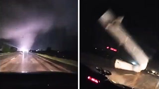
Active AlertsHillister, TX
...The Flood Warning is extended for the following rivers inLouisiana...Texas...Bundick Creek At Bundick LakeSabine River Near Bon WierBayou Anacoco Near RosepineVillage Creek Near KountzePine Island Bayou Near Sour Lake...The Flood Warning continues for the following rivers inLouisiana...Texas...Calcasieu River Near GlenmoraWest Fork of The Calcasieu River At Sam Houston Jones SPCalcasieu River Near Salt Water BarrierCalcasieu River near White Oak ParkCalcasieu River Near KinderSabine River Near DeweyvilleNeches River Near EvadaleNeches River Near Town BluffNeches River at Neches River Saltwater BarrierAdditional information is available at www.weather.gov.The next statement will be issued this afternoon at 245 PM CDT.* WHAT...Minor flooding is occurring and minor flooding is forecast.* WHERE...Neches River near Town Bluff.* WHEN...Until further notice.* IMPACTS...At 73.0 feet, Flooding expected in the Mont Neches,Barlow Lake and Sheffields Ferry communities. Some homes maybecome flooded as well, especially in the Barlow Lake community.* ADDITIONAL DETAILS...- At 9:00 AM CDT Wednesday the stage was 70.9 feet.- Recent Activity...The maximum river stage in the 24 hoursending at 9:00 AM CDT Wednesday was 71.2 feet.- Forecast...The river is expected to rise to a crest of 71.6feet this afternoon.- Flood stage is 68.0 feet.- http://www.weather.gov/safety/flood