Active AlertsDoucette, TX
You should monitor later forecasts and be alert for possible FloodWarnings. Those living in areas prone to flooding should be preparedto take action should flooding develop.
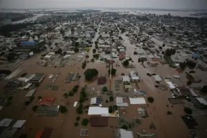
* WHAT...Flooding caused by excessive rainfall continues to bepossible.* WHERE...A portion of southeast Texas, including the followingareas, Hardin, Lower Jefferson, Northern Jasper, Northern Newton,Northern Orange, Southern Jasper, Southern Newton, SouthernOrange, Tyler and Upper Jefferson.* WHEN...Through this evening.* IMPACTS...Excessive runoff may result in flooding of rivers,creeks, streams, and other low-lying and flood-prone locations.* ADDITIONAL DETAILS...- Another round of showers and storms is expected to move overthe region tonight into Sunday. Showers and storms will becapable of producing heavy rainfall and high rainfall rates.Additional rainfall totals of 1 to 3 inches are expected withlocalized amounts up to 6 inches possible. This activity willmove over areas already saturated from heavy rainfall overthe past several days, and will exacerbate ongoing floodingacross the area.- http://www.weather.gov/safety/flood
...The Flood Warning continues for the following rivers in Texas...Neches River Near EvadaleNeches River Near Town BluffNeches River at Neches River Saltwater BarrierVillage Creek Near KountzePine Island Bayou Near Sour LakeAdditional information is available at www.weather.gov.The next statement will be issued Monday morning at 900 AM CDT.* WHAT...Moderate flooding is occurring and moderate flooding isforecast.* WHERE...Neches River near Town Bluff.* WHEN...Until further notice.* IMPACTS...At 73.0 feet, Flooding expected in the Mont Neches,Barlow Lake and Sheffields Ferry communities. Some homes maybecome flooded as well, especially in the Barlow Lake community.* ADDITIONAL DETAILS...- At 8:00 AM CDT Sunday the stage was 72.6 feet.- Recent Activity...The maximum river stage in the 24 hoursending at 8:00 AM CDT Sunday was 72.6 feet.- Forecast...The river is expected to rise to a crest of 74.5feet Tuesday morning.- Flood stage is 68.0 feet.- http://www.weather.gov/safety/flood