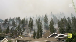
Active AlertsDallardsville, TX
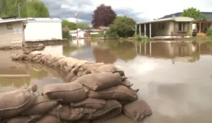
Turn around, don't drown when encountering flooded roads. Most flooddeaths occur in vehicles.Motorists should not attempt to drive around barricades or drivecars through flooded areas.Please report observed flooding to local emergency services or lawenforcement and request they pass this information to the NationalWeather Service when you can do so safely.To escape rising water, take the shortest path to higher ground.Additional information is available at www.weather.gov/hgx.The next statement will be issued by Tuesday morning at 830 AM CDT.
...The Flood Warning is extended for the following rivers in Texas...Menard Creek near Rye affecting Hardin, Liberty and Polk Counties.Bedias Creek near Madisonville affecting Walker and MadisonCounties.San Jacinto River near Sheldon affecting Harris County.West Fork San Jacinto near Humble affecting Harris and MontgomeryCounties....The Flood Warning continues for the following rivers in Texas...East Fork San Jacinto near New Caney affecting Liberty, Harrisand Montgomery Counties.Trinity River near Crockett affecting Houston, Walker, Trinityand Madison Counties.Trinity River near Romayor affecting Liberty, San Jacinto andPolk Counties.Trinity River at Liberty affecting Liberty County.Trinity River near Goodrich affecting Liberty, San Jacinto andPolk Counties.Trinity River near Moss Bluff affecting Liberty and ChambersCounties.Trinity River at Riverside affecting Walker, San Jacinto, Polkand Trinity Counties.Navasota River near Normangee affecting Brazos, Grimes andMadison Counties.For the Trinity River...including Crockett, Riverside, Romayor,Goodrich, Liberty, Moss Bluff...Major flooding is forecast.For the Menard Creek...including Rye...Minor flooding is forecast.For the East Fork San Jacinto River...including New Caney...Moderateflooding is forecast.For the West Fork San Jacinto River...including Humble, Sheldon...Major flooding is forecast.For the Navasota River...including Normangee...Major flooding isforecast.* WHAT...Minor flooding is occurring and minor flooding is forecast.* WHERE...Menard Creek near Rye.* WHEN...Until Wednesday evening.* IMPACTS...At 20.0 feet, Minor lowland flooding begins as waterescapes the main channel in the vicinity of the gage.* ADDITIONAL DETAILS...- At 2:15 PM CDT Monday the stage was 22.0 feet.- Bankfull stage is 17.0 feet.- Recent Activity...The maximum river stage in the 24 hoursending at 2:15 PM CDT Monday was 22.7 feet.- Forecast...The river is expected to fall below flood stageWednesday morning and continue falling to 15.2 feet earlySaturday afternoon.- Flood stage is 20.0 feet.- Flood History...This crest compares to a previous crest of21.9 feet on 05/15/2015.- http://www.weather.gov/safety/flood
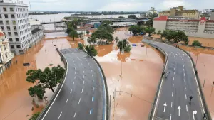
Turn around, don't drown when encountering flooded roads. Most flooddeaths occur in vehicles.Motorists should not attempt to drive around barricades or drivecars through flooded areas.Please report observed flooding to local emergency services or lawenforcement and request they pass this information to the NationalWeather Service when you can do so safely.To escape rising water, take the shortest path to higher ground.Additional information is available at www.weather.gov/hgx.The next statement will be issued by Tuesday morning at 830 AM CDT.
...The Flood Warning is extended for the following rivers in Texas...Menard Creek near Rye affecting Hardin, Liberty and Polk Counties.Bedias Creek near Madisonville affecting Walker and MadisonCounties.San Jacinto River near Sheldon affecting Harris County.West Fork San Jacinto near Humble affecting Harris and MontgomeryCounties....The Flood Warning continues for the following rivers in Texas...East Fork San Jacinto near New Caney affecting Liberty, Harrisand Montgomery Counties.Trinity River near Crockett affecting Houston, Walker, Trinityand Madison Counties.Trinity River near Romayor affecting Liberty, San Jacinto andPolk Counties.Trinity River at Liberty affecting Liberty County.Trinity River near Goodrich affecting Liberty, San Jacinto andPolk Counties.Trinity River near Moss Bluff affecting Liberty and ChambersCounties.Trinity River at Riverside affecting Walker, San Jacinto, Polkand Trinity Counties.Navasota River near Normangee affecting Brazos, Grimes andMadison Counties.For the Trinity River...including Crockett, Riverside, Romayor,Goodrich, Liberty, Moss Bluff...Major flooding is forecast.For the Menard Creek...including Rye...Minor flooding is forecast.For the East Fork San Jacinto River...including New Caney...Moderateflooding is forecast.For the West Fork San Jacinto River...including Humble, Sheldon...Major flooding is forecast.For the Navasota River...including Normangee...Major flooding isforecast.* WHAT...Major flooding is occurring and major flooding is forecast.* WHERE...Trinity River near Goodrich.* WHEN...Until further notice.* IMPACTS...At 46.8 feet, In past flood at levels above 46.8 feetmany homes below Lake Livingston were flooded...some with watermidway up their windows.* ADDITIONAL DETAILS...- At 1:45 PM CDT Monday the stage was 46.4 feet.- Bankfull stage is 36.0 feet.- Recent Activity...The maximum river stage in the 24 hoursending at 1:45 PM CDT Monday was 46.8 feet.- Forecast...The river is expected to remain steady above floodstage at 46.4 feet.- Flood stage is 36.0 feet.- Flood History...This crest compares to a previous crest of46.4 feet on 06/14/1973.- http://www.weather.gov/safety/flood
Turn around, don't drown when encountering flooded roads. Most flooddeaths occur in vehicles.Motorists should not attempt to drive around barricades or drivecars through flooded areas.Please report observed flooding to local emergency services or lawenforcement and request they pass this information to the NationalWeather Service when you can do so safely.To escape rising water, take the shortest path to higher ground.Additional information is available at www.weather.gov/hgx.The next statement will be issued by Tuesday morning at 830 AM CDT.
...The Flood Warning is extended for the following rivers in Texas...Menard Creek near Rye affecting Hardin, Liberty and Polk Counties.Bedias Creek near Madisonville affecting Walker and MadisonCounties.San Jacinto River near Sheldon affecting Harris County.West Fork San Jacinto near Humble affecting Harris and MontgomeryCounties....The Flood Warning continues for the following rivers in Texas...East Fork San Jacinto near New Caney affecting Liberty, Harrisand Montgomery Counties.Trinity River near Crockett affecting Houston, Walker, Trinityand Madison Counties.Trinity River near Romayor affecting Liberty, San Jacinto andPolk Counties.Trinity River at Liberty affecting Liberty County.Trinity River near Goodrich affecting Liberty, San Jacinto andPolk Counties.Trinity River near Moss Bluff affecting Liberty and ChambersCounties.Trinity River at Riverside affecting Walker, San Jacinto, Polkand Trinity Counties.Navasota River near Normangee affecting Brazos, Grimes andMadison Counties.For the Trinity River...including Crockett, Riverside, Romayor,Goodrich, Liberty, Moss Bluff...Major flooding is forecast.For the Menard Creek...including Rye...Minor flooding is forecast.For the East Fork San Jacinto River...including New Caney...Moderateflooding is forecast.For the West Fork San Jacinto River...including Humble, Sheldon...Major flooding is forecast.For the Navasota River...including Normangee...Major flooding isforecast.* WHAT...Moderate flooding is occurring and moderate flooding isforecast.* WHERE...Trinity River at Riverside.* WHEN...Until further notice.* IMPACTS...At 138.0 feet, Moderate lowland flooding continues withwater 3 to 4 feet below the State Highway 19 Bridge and PlantationDrive near FM 230 is inundated. FM 2978 is flooded and impassable.Up to one foot of water is flowing over Thomas Lake Road whichremains impassable. Several roads into the Green Rich Shores andDeep River Plantation subdivisions are covered with up to one footof water and homes in Deep River Plantation are threatened.* ADDITIONAL DETAILS...- At 1:30 PM CDT Monday the stage was 139.6 feet.- Bankfull stage is 133.0 feet.- Recent Activity...The maximum river stage in the 24 hoursending at 1:30 PM CDT Monday was 140.2 feet.- Forecast...The river is expected to rise to a crest of 139.6feet this evening.- Flood stage is 133.5 feet.- Flood History...This crest compares to a previous crest of139.6 feet on 05/04/1957.- http://www.weather.gov/safety/flood