Active AlertsCooper, TX
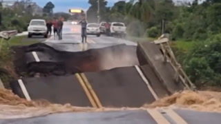
Do not drive cars through flooded areas.Caution is urged when walking near riverbanks.Turn around, don't drown when encountering flooded roads. Most flooddeaths occur in vehicles.For more hydrologic information, copy and paste the following websiteaddress into your favorite web browser URL bar:water.weather.gov/ahps2/index.php?wfo=shvThe next statement will be issued Wednesday morning at 1045 AM CDT.
...The Flood Warning continues for the following rivers in Texas...Neches River At Rockland affecting Angelina, Jasper, Tyler andPolk Counties.Neches River Near Diboll affecting Polk, Trinity, Tyler, Houstonand Angelina Counties.Neches River Near Alto affecting Trinity, Cherokee, Houston andAnderson Counties.Neches River Near Neches affecting Cherokee, Houston and AndersonCounties.For the Neches River...including Neches, Alto, Diboll, Rockland...Moderate flooding is forecast.* WHAT...Minor flooding is occurring and minor flooding is forecast.* WHERE...Neches River near Neches.* WHEN...Until further notice.* IMPACTS...At 14.0 feet, Minor lowland flooding. Move livestockand equipment to higher ground away from the river.* ADDITIONAL DETAILS...- At 9:30 AM CDT Tuesday the stage was 15.3 feet.- Bankfull stage is 12.0 feet.- Recent Activity...The maximum river stage in the 24 hoursending at 9:30 AM CDT Tuesday was 15.3 feet.- Forecast...The river is currently at crest, with a slow fallcommencing tonight through this weekend.- Flood stage is 12.0 feet.- Flood History...This crest compares to a previous crest of15.5 feet on 11/09/2015.- http://www.weather.gov/safety/flood
Do not drive cars through flooded areas.Caution is urged when walking near riverbanks.Turn around, don't drown when encountering flooded roads. Most flooddeaths occur in vehicles.For more hydrologic information, copy and paste the following websiteaddress into your favorite web browser URL bar:water.weather.gov/ahps2/index.php?wfo=shvThe next statement will be issued Wednesday morning at 1045 AM CDT.
...The Flood Warning continues for the following rivers in Texas...Neches River At Rockland affecting Angelina, Jasper, Tyler andPolk Counties.Neches River Near Diboll affecting Polk, Trinity, Tyler, Houstonand Angelina Counties.Neches River Near Alto affecting Trinity, Cherokee, Houston andAnderson Counties.Neches River Near Neches affecting Cherokee, Houston and AndersonCounties.For the Neches River...including Neches, Alto, Diboll, Rockland...Moderate flooding is forecast.* WHAT...Minor flooding is occurring and minor flooding is forecast.* WHERE...Neches River near Diboll.* WHEN...Until further notice.* IMPACTS...At 16.0 feet, Lowland flooding will slowly decrease forthe next several days.* ADDITIONAL DETAILS...- At 9:15 AM CDT Tuesday the stage was 15.3 feet.- Bankfull stage is 12.0 feet.- Recent Activity...The maximum river stage in the 24 hoursending at 9:15 AM CDT Tuesday was 15.6 feet.- Forecast...The river will continue a slow fall through thisweek, but remain above the 12 foot flood stage throughSunday.- Flood stage is 12.0 feet.- Flood History...This crest compares to a previous crest of15.3 feet on 11/19/1946.- http://www.weather.gov/safety/flood