Active AlertsHomer, TN
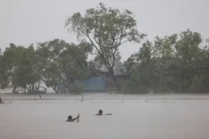
If you encounter a flooded roadway, turn around and find analternative route.Additional information is available at weather.gov/memphis.The next statement will be issued as needed.
...The National Weather Service in Memphis has issued a FloodAdvisory for the following rivers in Tennessee...Tennessee River at PerryvilleTennessee River at SavannahFor the Tennessee River...including Pickwick Dam, Savannah,Saltillo, Perryville, Johnsonville...elevated river levels areforecast.* WHAT...Flooding caused by excessive rainfall is expected.* WHERE...Tennessee River at Perryville.* WHEN...From this afternoon to Wednesday, June 05.* IMPACTS...At 363.5 feet, In Decatur County, water inundates theboat launch area at the north end of Woodlawn Shores Road inCherokee Heights and the low-lying areas of the boat launch at theend of Brodies Landing Road. The north end of Miracle Road inFishers Landing is flooding. The evacuation road from Beech BendPark boat parking lot floods.* ADDITIONAL DETAILS...- At 1:30 PM CDT Tuesday the stage was 361.3 feet.- Forecast...The river is expected to rise to a crest of 363.3feet Friday evening.- Action stage is 362.0 feet.- Flood stage is 365.0 feet.- http://www.weather.gov/safety/flood