Active AlertsChain-O-Lakes, MO
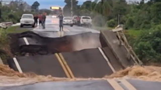
Turn around, don't drown when encountering flooded roads. Many flooddeaths occur in vehicles.
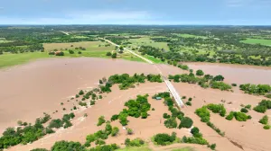
* WHAT...Flooding caused by excessive rainfall is expected.* WHERE...A portion of southwest Missouri, including the followingcounties, Barry, McDonald and Newton.* WHEN...Until noon CDT.* IMPACTS...Flooding of rivers, creeks, streams, and other low-lyingand flood-prone locations is imminent or occurring.* ADDITIONAL DETAILS...- At 608 AM CDT, The Department of Transportation and areariver gauges reported flooding from previous heavy rain inthe warned area. Between 1 and 3 inches of rain have fallen.- This includes the following low water crossings...Shoal Creek at Farm Road 2110, North Indian Creek at OrchidDrive, Flat Creek at Highway C, Butler Creek at KingsHighway, Flat Creek at Highway U, Little Sugar Creek atSkaggs Hollow Road and Big Sugar Creek at Buzzard Glory Road.- Some locations that will experience flooding include...Neosho, Monett, Cassville, Pineville, Anderson, Noel,Goodman, Purdy, South West City, Seligman, Exeter, Wheaton,Washburn, Lanagan, Fairview, Dodge, Shell Knob, Butterfield,Golden, Emerald Beach, Newtonia, Eagle Rock, Pioneer, Stella,Cayuga, Stark City, Chain-O-Lakes, Arrow Point, Ridgley,Rocky Comfort, Wayne, Powell, Mcdowell, Pleasant Ridge,Madry, Jenkins, Wheelerville, Tiff City, Table Rock Lake andBig Sugar Creek State Park.- http://www.weather.gov/safety/flood