Active AlertsUniversity Place, LA
You should monitor later forecasts and be prepared to take actionshould Flash Flood Warnings be issued.
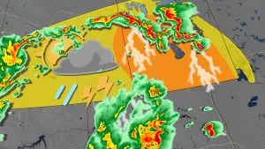
* WHAT...Flash flooding caused by excessive rainfall continues to bepossible.* WHERE...Portions of Louisiana, including the following parishes,Allen, Avoyelles, Beauregard, Evangeline, Lafayette, NorthernAcadia, Northern Calcasieu, Northern Jefferson Davis, Rapides,Southern Acadia, Southern Calcasieu, Southern Jefferson Davis, St.Landry, Upper St. Martin, Upper Vermilion and Vernon and southeastTexas, including the following areas, Hardin, Lower Jefferson,Northern Jasper, Northern Newton, Northern Orange, SouthernJasper, Southern Newton, Southern Orange, Tyler and UpperJefferson.* WHEN...Through late Friday night.* IMPACTS...Excessive runoff may result in flooding of rivers,creeks, streams, and other low-lying and flood-prone locations.Creeks and streams may rise out of their banks. Flooding may occurin poor drainage and urban areas.* ADDITIONAL DETAILS...- Another round of showers and thunderstorms is forecast onFriday afternoon into evening. Any additional rainfallfalling over locations with saturated grounds, along withhigh flows along area creeks, bayous, and drainage ditches,will bring about an increased risk of flash flooding.- http://www.weather.gov/safety/flood
...The Flood Warning continues for the following rivers inLouisiana...Texas...Bundick Creek At Bundick LakeBayou Anacoco Near RosepineVillage Creek Near KountzeWhisky Chitto Creek Near MittieCalcasieu River Near OakdaleCalcasieu River Near KinderCalcasieu River Near OberlinCalcasieu River Near Salt Water BarrierCalcasieu River Near GlenmoraBayou Nezpique Near BasileMermentau River Near MermentauSabine River Near BurkevilleSabine River Near Bon WierSabine River Near DeweyvilleNeches River Near EvadaleNeches River Near Town BluffNeches River at Neches River Saltwater BarrierPine Island Bayou Near Sour Lake...The Flood Warning is extended for the following rivers inLouisiana...Bayou Des Cannes Near EuniceAdditional information is available at www.weather.gov.The next statement will be issued Friday evening at 815 PM CDT.* WHAT...Minor flooding is forecast.* WHERE...Calcasieu River near Salt Water Barrier.* WHEN...Until further notice.* IMPACTS...At 4.5 feet, Water covers portions of River Road innorth Lake Charles.* ADDITIONAL DETAILS...- There is no current observed data.- Forecast...The river will oscillate around flood stage with amaximum value of 4.5 feet Monday morning.- Flood stage is 4.0 feet.- http://www.weather.gov/safety/flood
...The Flood Warning continues for the following rivers inLouisiana...Texas...Bundick Creek At Bundick LakeBayou Anacoco Near RosepineVillage Creek Near KountzeWhisky Chitto Creek Near MittieCalcasieu River Near OakdaleCalcasieu River Near KinderCalcasieu River Near OberlinCalcasieu River Near Salt Water BarrierCalcasieu River Near GlenmoraBayou Nezpique Near BasileMermentau River Near MermentauSabine River Near BurkevilleSabine River Near Bon WierSabine River Near DeweyvilleNeches River Near EvadaleNeches River Near Town BluffNeches River at Neches River Saltwater BarrierPine Island Bayou Near Sour Lake...The Flood Warning is extended for the following rivers inLouisiana...Bayou Des Cannes Near EuniceAdditional information is available at www.weather.gov.The next statement will be issued Friday evening at 815 PM CDT.* WHAT...Moderate flooding is occurring and moderate flooding isforecast.* WHERE...Sabine River near Deweyville.* WHEN...Until further notice.* IMPACTS...At 27.9 feet, This flooding will be similar to theflooding expierenced in the flood of March 2001. Homes inDeweyville have water in them.* ADDITIONAL DETAILS...- At 7:45 PM CDT Thursday the stage was 27.0 feet.- Recent Activity...The maximum river stage in the 24 hoursending at 7:45 PM CDT Thursday was 27.0 feet.- Forecast...The river is expected to rise to 27.9 feet earlyTuesday afternoon. Additional rises are possible thereafter.- Flood stage is 24.0 feet.- http://www.weather.gov/safety/flood