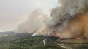
Active AlertsKrotz Springs, LA
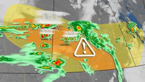
You should monitor later forecasts and be prepared to take actionshould Flash Flood Warnings be issued.
* WHAT...Flash flooding caused by excessive rainfall continues to bepossible.* WHERE...Portions of Louisiana, including the following parishes,Allen, Avoyelles, Beauregard, Evangeline, Lafayette, NorthernAcadia, Northern Calcasieu, Northern Jefferson Davis, Rapides,Southern Acadia, Southern Calcasieu, Southern Jefferson Davis, St.Landry, Upper St. Martin, Upper Vermilion and Vernon and southeastTexas, including the following areas, Hardin, Lower Jefferson,Northern Jasper, Northern Newton, Northern Orange, SouthernJasper, Southern Newton, Southern Orange, Tyler and UpperJefferson.* WHEN...Through Friday afternoon.* IMPACTS...Excessive runoff may result in flooding of rivers,creeks, streams, and other low-lying and flood-prone locations.Creeks and streams may rise out of their banks. Flooding may occurin poor drainage and urban areas.* ADDITIONAL DETAILS...- A storm system will slowly move through the region Thursdayand Friday. Widespread rainfall of 2 to 6 inches is possiblewith the potential for 6 to 12 inches locally. SoutheastTexas north of I-10 into south-central Louisiana has thehighest probability of seeing these higher totals. This willfall on already saturated soils and with ongoing flooding andor elevated water ways. Rainfall rates with the strongestshowers and storms will be in excess of 2 inches in one hour.Another round of showers and storms will be possible laterFriday into early Saturday, but confidence is too low toinclude in the watch at this time.- http://www.weather.gov/safety/flood