Active AlertsGurley, LA
You should monitor later forecasts and be alert for possible FloodWarnings. Those living in areas prone to flooding should be preparedto take action should flooding develop.
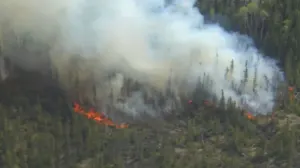
* WHAT...Flooding caused by excessive rainfall is possible.* WHERE...Portions of southeast Louisiana, including the followingparishes, Central Tangipahoa, East Baton Rouge, East Feliciana,Iberville, Northern Livingston, Northern Tangipahoa, PointeCoupee, St. Helena, Washington, West Baton Rouge and WestFeliciana and southern Mississippi, including the followingcounties, Amite, Pike, Walthall and Wilkinson.* WHEN...From Thursday evening through Saturday morning.* IMPACTS...Excessive runoff may result in flooding of rivers,creeks, streams, and other low-lying and flood-prone locations.Flooding may occur in poor drainage and urban areas.* ADDITIONAL DETAILS...- Multiple rounds of storms will be moving through the areabeginning Thursday night and continuing into Saturdaymorning. 2 to 4 inches of rainfall with locally higheramounts in excess of 6 inches will be possible, enhancing theflash flooding threat.- http://www.weather.gov/safety/flood