Active AlertsDarlington, LA
You should monitor later forecasts and be alert for possible FloodWarnings. Those living in areas prone to flooding should be preparedto take action should flooding develop.
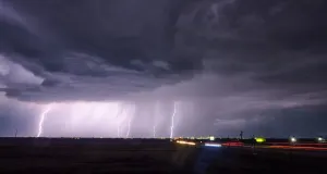
* WHAT...Flooding caused by excessive rainfall continues to bepossible.* WHERE...Portions of southeast Louisiana, including the followingparishes, Assumption, Central Plaquemines, Central Tangipahoa,East Baton Rouge, East Feliciana, Eastern Ascension, EasternOrleans, Iberville, Lower Jefferson, Lower Tangipahoa, NorthernLivingston, Northern St. Tammany, Northern Tangipahoa, SoutheastSt. Tammany, Southern Livingston, Southwestern St. Tammany, St.Charles, St. Helena, St. James, St. John The Baptist, UpperJefferson, Upper Lafourche, Upper Plaquemines, Upper St. Bernard,Upper Terrebonne, Washington, West Baton Rouge, Western Ascensionand Western Orleans and southern Mississippi, including thefollowing areas, Northern Hancock, Northern Harrison, NorthernJackson, Pearl River, Southern Hancock, Southern Harrison andSouthern Jackson.* WHEN...Through Saturday morning.* IMPACTS...Excessive runoff may result in flooding of rivers,creeks, streams, and other low-lying and flood-prone locations.Flooding may occur in poor drainage and urban areas.* ADDITIONAL DETAILS...- Thunderstorms capable of producing heavy rainfall will bemoving through the area again tonight. The risk for flashflooding will increase as these storms move through, and anadditional 1 to 3 inches of rainfall with locally higheramounts is possible.- http://www.weather.gov/safety/flood