Active AlertsWindsor Heights, IA
You should monitor later forecasts and be prepared to take actionshould Flash Flood Warnings be issued.For the latest river and stream observations and forecasts refer toweather.gov/desmoines/water.
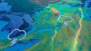
* WHAT...Flash flooding caused by excessive rainfall continues to bepossible.* WHERE...Portions of central, north central, northeast, northwest,south central, southwest, and west central Iowa, including thefollowing counties, in central Iowa, Boone, Dallas, Grundy,Hamilton, Hardin, Jasper, Marshall, Polk, Poweshiek, Story, Tamaand Webster. In north central Iowa, Butler, Cerro Gordo, Franklin,Hancock, Humboldt, Kossuth, Winnebago, Worth and Wright. Innortheast Iowa, Black Hawk and Bremer. In northwest Iowa, Emmet,Palo Alto and Pocahontas. In south central Iowa, Madison, Mahaska,Marion and Warren. In southwest Iowa, Adair and Cass. In westcentral Iowa, Audubon, Calhoun, Carroll, Crawford, Greene, Guthrieand Sac.* WHEN...Through this evening.* IMPACTS...Excessive runoff may result in flooding of rivers,creeks, streams, and other low-lying and flood-prone locations.Flooding may occur in poor drainage and urban areas.* ADDITIONAL DETAILS...- 3 to 5 inches of rain have already fallen over portions ofnorthern and north central Iowa. Slow moving storms withefficient rainfall rates will continue through the earlymorning hours, and could impact the morning commute.
If outdoors, consider seeking shelter inside a building.Torrential rainfall is also occurring with this storm and may lead tolocalized flooding. Do not drive your vehicle through floodedroadways.
At 410 AM CDT, Doppler radar was tracking a cluster of strongthunderstorms over Ankeny, moving slowly south at 15 mph.HAZARD...Additional heavy rainfall of one to two inches per hour.SOURCE...Radar indicated.IMPACT...Considerable ponding of water on streets and roadways, lowvisibilities, and rises in small streams and creeks. Thismay impact travel during the morning commute.Locations impacted include...Des Moines, Ames, West Des Moines, Ankeny, Urbandale, Johnston,Clive, Altoona, Norwalk, Pleasant Hill, Grimes, Nevada, WindsorHeights, Carlisle, Bondurant, Polk City, Huxley, Saylorville,Mitchellville, and Slater.This includes the following highways...Interstate 35 between mile markers 67 and 72, and between milemarkers 87 and 113.Interstate 80 between mile markers 122 and 149.Interstate 235 between mile markers 1 and 14.