Active AlertsMinerva, IA
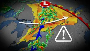
THE NATIONAL WEATHER SERVICE HAS ISSUED SEVERE THUNDERSTORM WATCH275 IN EFFECT UNTIL 1 PM CDT THIS AFTERNOON FOR THE FOLLOWINGAREASIN IOWA THIS WATCH INCLUDES 38 COUNTIESIN CENTRAL IOWABOONE DALLAS GRUNDYHAMILTON HARDIN JASPERMARSHALL POLK POWESHIEKSTORY TAMA WEBSTERIN NORTHEAST IOWABLACK HAWKIN SOUTH CENTRAL IOWAAPPANOOSE CLARKE DECATURLUCAS MADISON MAHASKAMARION MONROE RINGGOLDUNION WARREN WAYNEIN SOUTHEAST IOWADAVIS WAPELLOIN SOUTHWEST IOWAADAIR ADAMS CASSTAYLORIN WEST CENTRAL IOWAAUDUBON CALHOUN CARROLLCRAWFORD GREENE GUTHRIESACTHIS INCLUDES THE CITIES OF ACKLEY, ADAIR, ADEL, ALBIA, ALLERTON,AMES, ATLANTIC, AUDUBON, BAYARD, BEDFORD, BLOOMFIELD, BOONE,CARLISLE, CARROLL, CASEY, CEDAR FALLS, CENTERVILLE, CHARITON,CONRAD, CORNING, CORYDON, CRESTON, DENISON, DES MOINES, DIKE,DYSART, EARLHAM, EARLY, ELDORA, EXIRA, FONTANELLE, FORT DODGE,GLADBROOK, GREENFIELD, GRINNELL, GRUNDY CENTER, GUTHRIE CENTER,HUMESTON, INDIANOLA, IOWA FALLS, JEFFERSON, KNOXVILLE, LAKE CITY,LAKE VIEW, LAMONI, LENOX, LEON, MANSON, MARSHALLTOWN, MOUNT AYR,NEW MARKET, NEWTON, NORWALK, ODEBOLT, OSCEOLA, OSKALOOSA,OTTUMWA, PANORA, PELLA, PERRY, POMEROY, REINBECK, ROCKWELL CITY,SAC CITY, SCHALLER, SEYMOUR, STUART, TAMA, TOLEDO, TRAER,WALL LAKE, WATERLOO, WAUKEE, WEBSTER CITY, WELLSBURG,AND WINTERSET.* PRIMARY THREATS INCLUDE...SCATTERED DAMAGING WINDS AND ISOLATED SIGNIFICANT GUSTS TO 75MPH POSSIBLE.ISOLATED LARGE HAIL EVENTS TO 1.5 INCHES IN DIAMETER POSSIBLE.A TORNADO OR TWO POSSIBLE.PROBABILITY TABLE:PROB OF 2 OR MORE TORNADOES : 20%PROB OF 1 OR MORE STRONG /EF2-EF5/ TORNADOES : 10%PROB OF 10 OR MORE SEVERE WIND EVENTS : 50%PROB OF 1 OR MORE WIND EVENTS >= 75 MPH : 50%PROB OF 10 OR MORE SEVERE HAIL EVENTS : 30%PROB OF 1 OR MORE HAIL EVENTS >= 2 INCHES : 10%PROB OF 6 OR MORE COMBINED SEVERE HAIL/WIND EVENTS : 70%MEAN STORM MOTION /MPH/ : E 50
You should monitor later forecasts and be prepared to take actionshould Flash Flood Warnings be issued.For the latest river and stream observations and forecasts refer toweather.gov/desmoines/water.
* WHAT...Flash flooding caused by excessive rainfall continues to bepossible.* WHERE...Portions of central, north central, northeast, northwest,south central, southwest, and west central Iowa, including thefollowing counties, in central Iowa, Boone, Dallas, Grundy,Hamilton, Hardin, Jasper, Marshall, Polk, Poweshiek, Story, Tamaand Webster. In north central Iowa, Butler, Cerro Gordo, Franklin,Hancock, Humboldt, Kossuth, Winnebago, Worth and Wright. Innortheast Iowa, Black Hawk and Bremer. In northwest Iowa, Emmet,Palo Alto and Pocahontas. In south central Iowa, Madison, Mahaska,Marion and Warren. In southwest Iowa, Adair and Cass. In westcentral Iowa, Audubon, Calhoun, Carroll, Crawford, Greene, Guthrieand Sac.* WHEN...Through this evening.* IMPACTS...Excessive runoff may result in flooding of rivers,creeks, streams, and other low-lying and flood-prone locations.Flooding may occur in poor drainage and urban areas.* ADDITIONAL DETAILS...- 3 to 5 inches of rain have already fallen over portions ofnorthern and north central Iowa. Slow moving storms withefficient rainfall rates will continue through the earlymorning hours, and could impact the morning commute.
Turn around, don't drown when encountering flooded roads. Most flooddeaths occur in vehicles.For the latest river and stream observations and forecasts refer toweather.gov/desmoines/water.
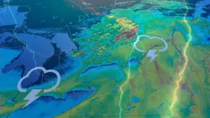
At 943 AM CDT, Doppler radar indicated thunderstorms producing heavyrain across the warned area. Between 5 and 6 inches of rain havefallen. Additional rainfall amounts of 1 to 2 inches are possible inthe warned area. Flash flooding is ongoing with several reports ofroads closed due to flash flooding as well as flash flooding ofhomes and other buildings in some areas.HAZARD...Life threatening flash flooding. Thunderstorms producingflash flooding.SOURCE...Radar.IMPACT...Life threatening flash flooding of creeks and streams,urban areas, highways, streets and underpasses.Some locations that will experience flash flooding include...Marshalltown, Newton, Grinnell, Toledo, Montezuma, Tama, Traer,Brooklyn, Dysart, Meskwaki Casino, Rock Creek Lake, Iowa Speedway,Gladbrook, Le Grand, Victor, Kellogg, Garwin, Gilman, Holiday Lakeand Malcom.
Remain alert for a possible tornado! Tornadoes can develop quicklyfrom severe thunderstorms. If you spot a tornado go at once into thebasement or small central room in a sturdy structure.For your protection move to an interior room on the lowest floor of abuilding.
At 1010 AM CDT, severe thunderstorms were located along a lineextending from 4 miles northwest of Haverhill to near Rock CreekState Park to 6 miles south of Sully, moving northeast at 45 mph.HAZARD...60 mph wind gusts and quarter size hail.SOURCE...Radar indicated.IMPACT...Hail damage to vehicles is expected. Expect wind damage toroofs, siding, and trees.Locations impacted include...Marshalltown, Newton, Grinnell, State Center, Rock Creek Lake, IowaSpeedway, Melbourne, Kellogg, Gilman, Albion, Laurel, Haverhill,Oakland Acres, Ferguson, Grinnell Regional Airport, MarshalltownMunicipal Airport, Rock Creek State Park, and Newton MunicipalAirport.This includes Interstate 80 between mile markers 165 and 185.