Active AlertsMackey, IA
Remain alert for a possible tornado! Tornadoes can develop quicklyfrom severe thunderstorms. If you spot a tornado go at once into thebasement or small central room in a sturdy structure.For your protection move to an interior room on the lowest floor of abuilding.A Tornado Watch remains in effect until 900 PM CDT for central andsouth central Iowa.
SVRDMXThe National Weather Service in Des Moines has issued a* Severe Thunderstorm Warning for...Northwestern Lucas County in south central Iowa...Polk County in central Iowa...Northwestern Decatur County in south central Iowa...Story County in central Iowa...Eastern Madison County in south central Iowa...Eastern Union County in south central Iowa...Southeastern Boone County in central Iowa...Clarke County in south central Iowa...Eastern Dallas County in central Iowa...Warren County in south central Iowa...* Until 515 PM CDT.* At 410 PM CDT, severe thunderstorms were located along a lineextending from 4 miles west of Granger to near Grand River, movingnortheast at 60 mph.HAZARD...60 mph wind gusts and quarter size hail.SOURCE...Radar indicated.IMPACT...Hail damage to vehicles is expected. Expect wind damageto roofs, siding, and trees.* Locations impacted include...Des Moines, Ames, West Des Moines, Ankeny, Urbandale, Johnston,Clive, Indianola, Altoona, Waukee, Norwalk, Pleasant Hill, Grimes,Nevada, Winterset, Osceola, Adel, Windsor Heights, Carlisle, andBondurant.This includes the following highways...Interstate 35 between mile markers 27 and 72, and between milemarkers 87 and 126.Interstate 80 between mile markers 109 and 149.Interstate 235 between mile markers 1 and 14.
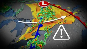
THE NATIONAL WEATHER SERVICE HAS ISSUED TORNADO WATCH 277 INEFFECT UNTIL 9 PM CDT THIS EVENING FOR THE FOLLOWING AREASIN IOWA THIS WATCH INCLUDES 32 COUNTIESIN CENTRAL IOWABOONE DALLAS GRUNDYHAMILTON HARDIN JASPERMARSHALL POLK STORYWEBSTERIN NORTH CENTRAL IOWABUTLER CERRO GORDO FRANKLINHANCOCK HUMBOLDT KOSSUTHWINNEBAGO WORTH WRIGHTIN NORTHEAST IOWABREMERIN NORTHWEST IOWAEMMET PALO ALTO POCAHONTASIN SOUTHWEST IOWAADAIR CASSIN WEST CENTRAL IOWAAUDUBON CALHOUN CARROLLCRAWFORD GREENE GUTHRIESACTHIS INCLUDES THE CITIES OF ACKLEY, ADAIR, ADEL, ALGONA, ALLISON,AMES, APLINGTON, ATLANTIC, AUDUBON, BAYARD, BELMOND, BOONE,BRITT, CARROLL, CASEY, CLARION, CLARKSVILLE, CLEAR LAKE, CONRAD,DENISON, DES MOINES, DIKE, DUMONT, EAGLE GROVE, EARLY, ELDORA,EMMETSBURG, ESTHERVILLE, EXIRA, FONDA, FONTANELLE, FOREST CITY,FORT DODGE, GARNER, GILMORE CITY, GREENE, GREENFIELD,GRUNDY CENTER, GUTHRIE CENTER, HAMPTON, HUMBOLDT, IOWA FALLS,JEFFERSON, KANAWHA, LAKE CITY, LAKE MILLS, LAKE VIEW, LAURENS,MANLY, MANSON, MARSHALLTOWN, MASON CITY, NEWTON, NORTHWOOD,ODEBOLT, PANORA, PARKERSBURG, PERRY, POCAHONTAS, POMEROY,REINBECK, ROCKWELL CITY, ROLFE, SAC CITY, SCHALLER, SHELL ROCK,STUART, WALL LAKE, WAUKEE, WAVERLY, WEBSTER CITY, AND WELLSBURG....THIS IS A PARTICULARLY DANGEROUS SITUATION. STRONG LONG LIVEDTORNADOES MAY OCCUR...* PRIMARY THREATS INCLUDE...SEVERAL TORNADOES AND A FEW INTENSE TORNADOES LIKELY.WIDESPREAD DAMAGING WINDS AND ISOLATED SIGNIFICANT GUSTS TO 90MPH LIKELY.SCATTERED LARGE HAIL LIKELY WITH ISOLATED VERY LARGE HAIL EVENTSTO 4 INCHES IN DIAMETER POSSIBLE.PROBABILITY TABLE:PROB OF 2 OR MORE TORNADOES : 90%PROB OF 1 OR MORE STRONG /EF2-EF5/ TORNADOES : 80%PROB OF 10 OR MORE SEVERE WIND EVENTS : 80%PROB OF 1 OR MORE WIND EVENTS >= 75 MPH : 60%PROB OF 10 OR MORE SEVERE HAIL EVENTS : 60%PROB OF 1 OR MORE HAIL EVENTS >= 2 INCHES : 50%PROB OF 6 OR MORE COMBINED SEVERE HAIL/WIND EVENTS : >95%MEAN STORM MOTION /MPH/ : NE 50
You should monitor later forecasts and be prepared to take actionshould Flash Flood Warnings be issued.For the latest river and stream observations and forecasts refer toweather.gov/desmoines/water.
* WHAT...Flash flooding caused by excessive rainfall continues to bepossible.* WHERE...Much of central Iowa.* WHEN...Until 7 PM CDT this evening.* IMPACTS...Excessive runoff may result in flooding of rivers,creeks, streams, and other low-lying and flood-prone locations.Flooding may occur in poor drainage and urban areas.* ADDITIONAL DETAILS...- Rainfall of 3 to 5 inches with isolated higher amounts fellover parts of central Iowa last night into this morning andled to flash flooding in some areas. Additional round ofstorms is expected this afternoon that may cause new flashflooding or prolong or renew flash flooding in areas thatexperienced flash flooding earlier.
...The Flood Watch continues for the following rivers in Iowa...Des Moines River near Stratford affecting Hamilton, Webster andBoone Counties.Des Moines River at Fort Dodge affecting Webster County.North Raccoon River near Perry affecting Greene and DallasCounties.River forecasts include observed precipitation plus forecastprecipitation over the next 24 hours.For the latest river and stream observations and forecasts refer toweather.gov/desmoines/water.* WHAT...Flooding is possible.* WHERE...The Des Moines River near Stratford, or from the BooneRiver...to near the City of Boone.* WHEN...From Thursday afternoon to late Sunday morning.* IMPACTS...At 17.8 feet, Water affects the lower Ledges road. Wateralso affects 155th St east of Fraser and Juniper Rd north ofFraser.At 18.8 feet, Water affects the 400 block of Juniper Rd...west ofFraser. Water also affects the 1100 block of 155th St...east ofFraser.At 19.0 feet, Water affects 157th St on the west side of Fraser.* ADDITIONAL DETAILS...- At 3:00 PM CDT Tuesday the stage was 11.7 feet.- Forecast...Flood stage may be reached Thursday afternoon.- Flood stage is 19.0 feet.
A Tornado Watch remains in effect until 900 PM CDT for central andwest central Iowa.For your protection move to an interior room on the lowest floor of abuilding.
At 416 PM CDT, a severe thunderstorm was located over Beaver, or 12miles east of Jefferson, moving northeast at 50 mph.HAZARD...60 mph wind gusts and quarter size hail.SOURCE...Radar indicated.IMPACT...Hail damage to vehicles is expected. Expect wind damage toroofs, siding, and trees.Locations impacted include...Boone, Ogden, Dayton, Grand Junction, Stratford, Rippey, Paton,Boxholm, Pilot Mound, Fraser, Dana, Beaver, Berkley, and Brushy CreekSt Recreation Area.