Active AlertsLake Park, IA
You should monitor later forecasts and be prepared to take actionshould Flash Flood Warnings be issued.
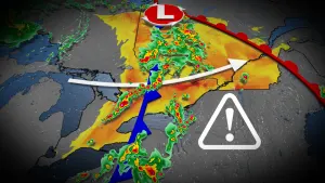
* WHAT...Flash flooding caused by excessive rainfall continues to bepossible.* WHERE...Portions of Iowa, including the following areas, BuenaVista, Cherokee, Clay, Dickinson, Ida, O'Brien and Woodbury,southwest Minnesota, including the following areas, Cottonwood andJackson, and northeast Nebraska, including the following area,Dakota.* WHEN...Until 7 PM CDT this evening.* IMPACTS...Excessive runoff may result in flooding of rivers,creeks, streams, and other low-lying and flood-prone locations.* ADDITIONAL DETAILS...- http://www.weather.gov/safety/flood
* WHAT...Northwest winds 25 to 35 mph with gusts up to 55 mphexpected.* WHERE...Portions of northwest Iowa, southwest Minnesota, and eastcentral South Dakota.* WHEN...From 2 PM this afternoon to 10 PM CDT this evening.* IMPACTS...Gusty winds could blow around unsecured objects. Treelimbs could be blown down and a few power outages may result.