Active AlertsLake Manawa, IA
Turn around, don't drown when encountering flooded roads. Most flooddeaths occur in vehicles.
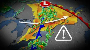
* WHAT...Flooding caused by excessive rainfall is occurring, and isexpected to continue through early afternoon.* WHERE...Portions of Harrison, Pottawattamie and Shelby counties inIowa, and Burt, Butler, Colfax, Dodge, Douglas, Saunders andWashington counties in Nebraska.* WHEN...Until 400 PM CDT Tuesday.* IMPACTS...Flooding of rivers, creeks, streams, and other low-lyingand flood-prone locations is occurring. While some of the smallerstreams have already reached their highest levels, some of thelarger streams will continue to rise due to excess runoff fromearlier rainfall. It will take several hours for all the waterfrom these storms to work through local drainage systems in someurban areas.* ADDITIONAL DETAILS...- At 727 AM CDT, emergency management, trained spotters,public, and broadcast media have reported heavy rain in thewarned area due to thunderstorms. Flooding is ongoing.Between 3 and 7 inches of rain have fallen in most of thewarned area, but up to 10 inches of rain is estimated byradar in western Saunders county.- Some locations within this larger flood warning remain in aflash flood warning. These areas can expect the continuedthreat of very rapid rises in water levels until those flashflood warnings expire.- Some locations that will experience flooding include...Omaha, northern Council Bluffs, Fremont, Blair, Harlan,Wahoo, David City, Tekamah, Bennington, Boys Town, Elkhorn,Carter Lake, Missouri Valley, Valley, Logan, Avoca,Arlington, North Bend, Yutan and Underwood.- http://www.weather.gov/safety/flood
You should monitor later forecasts and be alert for possible FloodWarnings. Those living in areas prone to flooding should be preparedto take action should flooding develop.
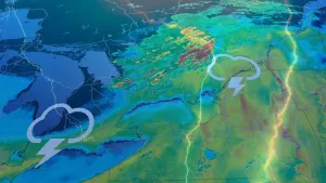
* WHAT...Flooding caused by excessive rainfall continues to bepossible.* WHERE...Portions of Iowa, including the following counties,Fremont, Harrison, Mills, Monona, Montgomery, Page, Pottawattamieand Shelby and Nebraska, including the following counties, Burt,Butler, Cass, Colfax, Cuming, Dodge, Douglas, Lancaster, Otoe,Platte, Saline, Sarpy, Saunders, Seward, Thurston and Washington.* WHEN...Through this evening.* IMPACTS...Excessive runoff may result in flooding of rivers,creeks, streams, and other low-lying and flood-prone locations.* ADDITIONAL DETAILS...- Thunderstorms will continue through the morning hours beforeending by early afternoon.- http://www.weather.gov/safety/flood