Active AlertsLacey, IA
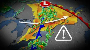
THE NATIONAL WEATHER SERVICE HAS ISSUED TORNADO WATCH 277 UNTIL9 PM CDT THIS EVENING. SEVERE THUNDERSTORM WATCH 275 HAS EXPIRED.THE NEW WATCH IS VALID FOR THE FOLLOWING AREASIN IOWA THE NEW WATCH INCLUDES 19 COUNTIESIN CENTRAL IOWAPOWESHIEK TAMAIN NORTHEAST IOWABLACK HAWKIN SOUTH CENTRAL IOWAAPPANOOSE CLARKE DECATURLUCAS MADISON MAHASKAMARION MONROE RINGGOLDUNION WARREN WAYNEIN SOUTHEAST IOWADAVIS WAPELLOIN SOUTHWEST IOWAADAMS TAYLORTHIS INCLUDES THE CITIES OF ALBIA, ALLERTON, BEDFORD, BLOOMFIELD,CARLISLE, CEDAR FALLS, CENTERVILLE, CHARITON, CORNING, CORYDON,CRESTON, DYSART, EARLHAM, GLADBROOK, GRINNELL, HUMESTON,INDIANOLA, KNOXVILLE, LAMONI, LENOX, LEON, MOUNT AYR, NEW MARKET,NORWALK, OSCEOLA, OSKALOOSA, OTTUMWA, PELLA, SEYMOUR, TAMA,TOLEDO, TRAER, WATERLOO, AND WINTERSET.
You should monitor later forecasts and be prepared to take actionshould Flash Flood Warnings be issued.For the latest river and stream observations and forecasts refer toweather.gov/desmoines/water.
* WHAT...Flash flooding caused by excessive rainfall continues to bepossible.* WHERE...Much of central Iowa.* WHEN...Until 7 PM CDT this evening.* IMPACTS...Excessive runoff may result in flooding of rivers,creeks, streams, and other low-lying and flood-prone locations.Flooding may occur in poor drainage and urban areas.* ADDITIONAL DETAILS...- Rainfall of 3 to 5 inches with isolated higher amounts fellover parts of central Iowa last night into this morning andled to flash flooding in some areas. Additional round ofstorms is expected this afternoon that may cause new flashflooding or prolong or renew flash flooding in areas thatexperienced flash flooding earlier.