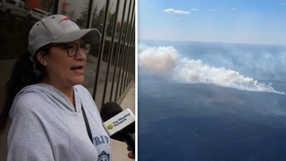
Active AlertsUpper Grand Lagoon, FL
You should monitor later forecasts and be alert for possible FloodWarnings. Those living in areas prone to flooding should be preparedto take action should flooding develop.
* WHAT...Flooding caused by excessive rainfall continues to bepossible.* WHERE...Portions of Florida, including the following areas,Calhoun, Central Walton, Coastal Bay, Coastal Franklin, CoastalGulf, Coastal Jefferson, Coastal Wakulla, Gadsden, Inland Bay,Inland Franklin, Inland Gulf, Inland Jefferson, Inland Wakulla,Leon, Liberty, South Walton and Washington and Georgia, includingthe following areas, Ben Hill, Berrien, Brooks, Colquitt, Cook,Decatur, Grady, Irwin, Thomas, Tift, Turner and Worth.* WHEN...Through this evening.* IMPACTS...Excessive runoff may result in flooding of rivers,creeks, streams, and other low-lying and flood-prone locations.Flooding may occur in poor drainage and urban areas. Low-watercrossings may be flooded. Extensive street flooding and floodingof creeks and rivers are possible. Area creeks and streams arerunning high and could flood with more heavy rain.* ADDITIONAL DETAILS...- Additional rounds of showers and thunderstorms will developacross the area this afternoon. Widespread rain totals willgenerally be around 1 to 2 inches but localized areas in theflood watch region could see 2 to 4 inches of new rainfall.Some of these rainfall amounts could occur across areas thatalready received heavier rains on Friday, this increasing theconcerns for localized flooding and/or flash flooding.- http://www.weather.gov/safety/flood
If outdoors, consider seeking shelter inside a building.
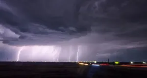
At 1048 AM EDT/948 AM CDT/, Doppler radar was tracking a cluster ofstrong thunderstorms near Panama City Beach, moving northeast at 35mph.HAZARD...Wind gusts up to 50 mph.SOURCE...Radar indicated.IMPACT...Gusty winds could knock down tree limbs and blow aroundunsecured objects.Locations impacted include...Panama City, Lynn Haven, Panama City Beach, Callaway, Springfield,Hiland Park, Moose Pond, St Andrews State Park, Southport, Fountain,Cedar Grove, Singer Road, Dirego Park, College Station, Gulf ResortBeach, Bayou George, West Panama City, Camp Flowers, Bahama Beach,and Gainer Spring.
Swim near a lifeguard. If caught in a rip current, relax andfloat. Don't swim against the current. If able, swim in adirection following the shoreline. If unable to escape, face theshore and call or wave for help.
* WHAT...Dangerous rip currents.* WHERE...Walton, Bay, Gulf, and Franklin County Beaches.* WHEN...Through late Sunday night.* IMPACTS...Rip currents can sweep even the best swimmers awayfrom shore into deeper water.