
Why does your long-range forecast change so often?

Forecasts grow more uncertain the farther into the future you look. Here’s an inside look at why your long-range forecast can seemingly change on a whim.
We’ve all been there—an outdoor event is coming up next week and we’re endlessly checking the forecast to make sure the weather will cooperate with our plans.
Today’s forecast for next week calls for sunny skies and pleasant temperatures. Tomorrow, though, the forecast suddenly changes and shows chilly, gloomy conditions for your big event.
Weather forecasts are much more accurate today than they were a few decades ago. Meteorologists can predict the weather three and five days out with an accuracy that would’ve been unthinkable not that long ago.
DON’T MISS: Scientists have figured out what a twinkling star sounds like - listen here
It’s very rare for your forecast to make large swings in the short range. But it’s not uncommon for your forecast to seem like a seesaw when you look at things more than a week or so in the future.
Why does your long-range forecast change so often? It’s all about uncertainty.
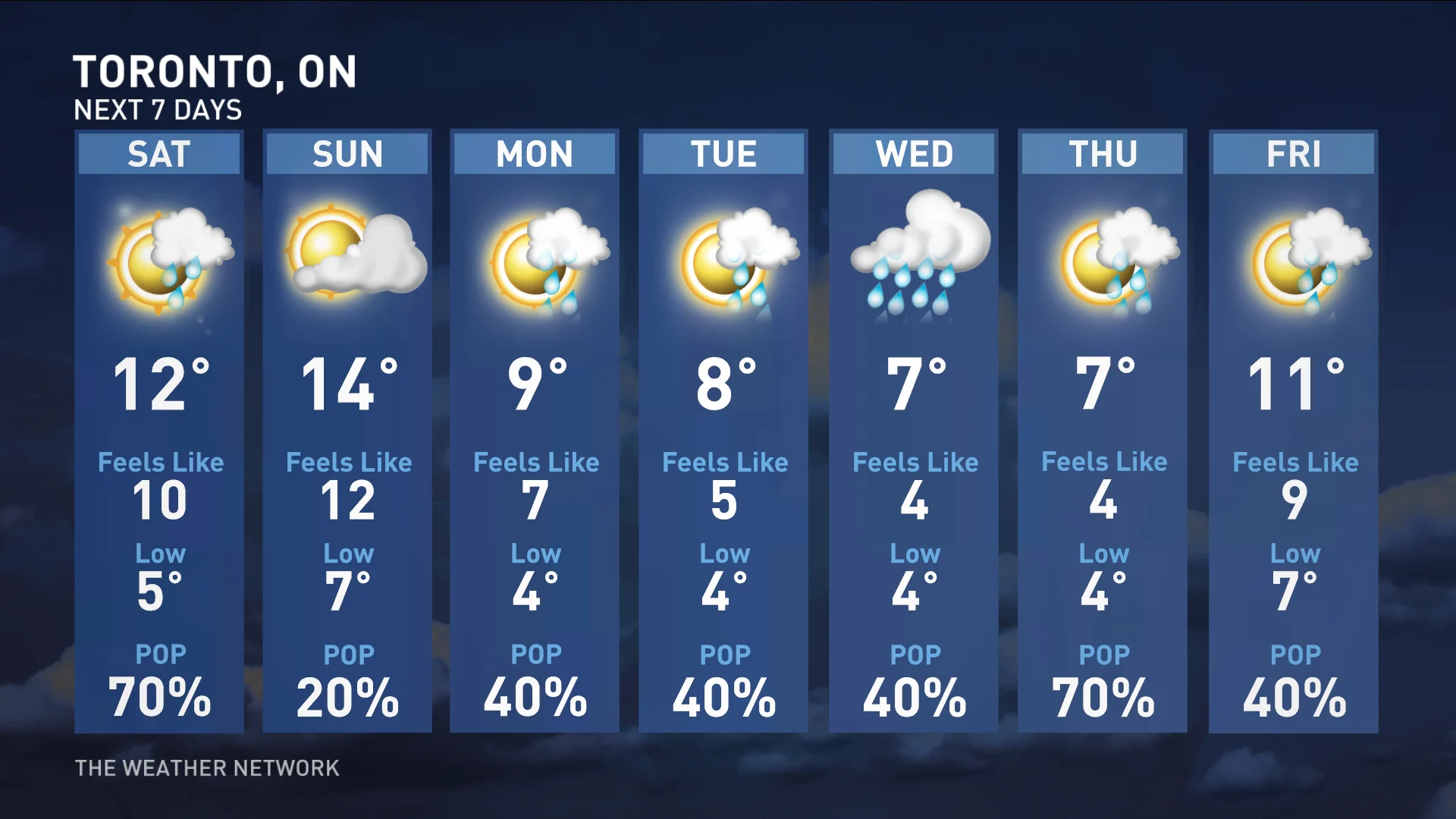
A seven-day forecast like the one shown above is accurate enough to point out specific high and low temperatures.
A short-range forecast is good at telling you tomorrow’s high temperature or the chance of rain in three days. A long-range forecast—covering weeks or even months away—is more about spotting trends.
It’s not possible to accurately predict the precise high temperature three weeks from today, but a forecaster can look at patterns to see whether or not we’ll see above- or below-seasonal temperatures in three weeks.
A long-range outlook, on the other hand, is intended to feel out weather patterns weeks or even months in the future.
Understanding why long-range forecasts include so much uncertainty is best explained by chaos.
Think about the “butterfly effect,” the old story about how the minute breeze of a butterfly flapping its wings in one part of the world can set off a chain reaction that spins up a hurricane on the other side of the planet.
Our atmosphere isn’t quite that sensitive to small changes, but tiny changes in the initial conditions within the atmosphere can make a big difference in the weather later on.
The speed, power, and placement of fronts, low-pressure centres, and even smaller features like individual thunderstorms can have a huge ripple effect that significantly changes the weather downstream in the days to come. The uncertainty introduced by these different variables only increases with time.
RELATED: Why those weather model maps you see on social media are probably bogus
Typhoons in the western Pacific can alter the jet stream and send volatile weather careening over Canada a week and a half later. Hurricanes in the Atlantic can spin up the eastern seaboard and disrupt what might have otherwise been a sunny day.
It’s not just large-scale patterns that can get tripped up, either.
WATCH: The science behind teleconnections
Hurricane Fiona’s historic landfall in Atlantic Canada is a solid example of how tiny changes in the atmosphere around a storm can have a huge effect on the storm’s ultimate track and strength.
The storm emerged from the Caribbean as a growing hurricane in the western Atlantic Ocean. Most storms taking Hurricane Fiona’s track would simply curve northeast and head out to sea, posing little threat to land.
Fiona encountered a complex setup, however, that allowed the storm to careen into Canada’s East Coast.
An upper-level trough latched onto the storm and pulled it into Canada like a magnet. This tricky interaction between hurricane and trough allowed the storm to grow as it made a sharp westward hook into Nova Scotia.
The results were disastrous, inflicting more widespread damage and power outages on the region than most other storms in living memory.
WATCH: Fiona vs. Ian: How these hurricanes tested the limits of weather forecasting
The entire future of Hurricane Fiona depended on the exact timing of that trough swinging into Eastern Canada.
If the trough had gone a little faster, it may have shielded Atlantic Canada from feeling the hurricane’s wrath. If it had gone a little slower, though, it could’ve pulled the hurricane into land sooner, hitting closer to Halifax or even missing altogether and hitting New England instead.
CHECK IT OUT: Why Ontario’s ‘snow snake’ caught many–including forecasters–off guard
That kind of atmospheric tapdance can be difficult to predict more than a few days out, let alone a few weeks in advance.
It’s the tiny details—those subtle shifts of a few kilometres one way or another—that can have a tremendous impact on your long-range forecast.
When you’re eagerly looking at the forecast more than a week in advance and the predicted highs and chance for precipitation flip around with each update, remember that tiny shifts thousands of kilometres away can dramatically alter what happens over your head down the line.
Thumbnail created using images from Unsplash.