
Ontario: Rain, flooding risks, and snow come with storm

Milder temperatures come at the cost of a spring-like storm at the end of this weekend.
While many are thrilled that the bitter cold spell has left southern Ontario, the warmth that moved into the region this weekend accompanied by rain, snow, and strong wind gusts. This significant spring-like storm has the potential for localized flooding and power outages. More on that, below.
Visit our Complete Guide to Spring 2019 for an in depth look at the Spring Forecast, tips to plan for it and much more.
WEATHER HIGHLIGHTS:
Brief period of freezing rain/drizzle expected through early Sunday
System more snowy for eastern areas, hefty helping of snow in north
Local flooding possible for southern regions
Latest weather alerts HERE
SPRING-LIKE STORM KICKS OFF MARCH BREAK
Saturday's sunny skies are a thing of the past, as widespread rain moves through southern Ontario, and snow targets northern and eastern regions, thanks to a potent low pressure system that began tracking into the Great Lakes region on Saturday night.
With the centre of the system tracking well north through the Nickel Belt, a surge of warmer temperatures will push into southern Ontario through Sunday, making this largely a rain event for most people.
WATCH BELOW: TIMING OF RAIN AND SNOW
The system should clear throughout the day on Sunday, with the possibility of a brief period of of flurries or a rain/snow mix for areas north, northwest, and east of the GTA.
(SEE ALSO: Four terrible effects of Daylight Saving Time)
GREATER CHANCE OF SNOW FOR EASTERN AREAS
East of the GTA, people can expect more snow from this system.
The system will largely remain as snow throughout the day, with a brief period of mixing for eastern Ontario Sunday evening, though there will be a slight risk of freezing rain and ice pellets in the evening hours. Ottawa and surrounding regions can expect to see an additional 10 cm today, and eastward to Montreal folks will see an additional 20 cm.
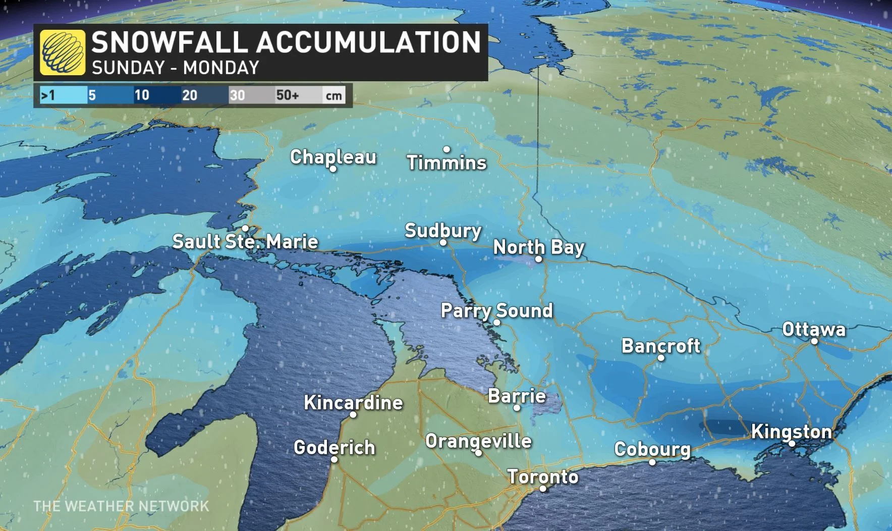
Beyond, a brief break is ahead Monday mid-morning to the afternoon, but wrap-around snow returns in the evening, easing into the night.
RAIN ACCOMPANIES FLOODING RISKS
The decent snowpack still in place for much of southern and central Ontario, combined with Sunday's warming temperatures and widespread rain could result in some localized flooding. Homeowners are urged to clear any storm drains or catch basins to ensure the clearance of accumulating water.
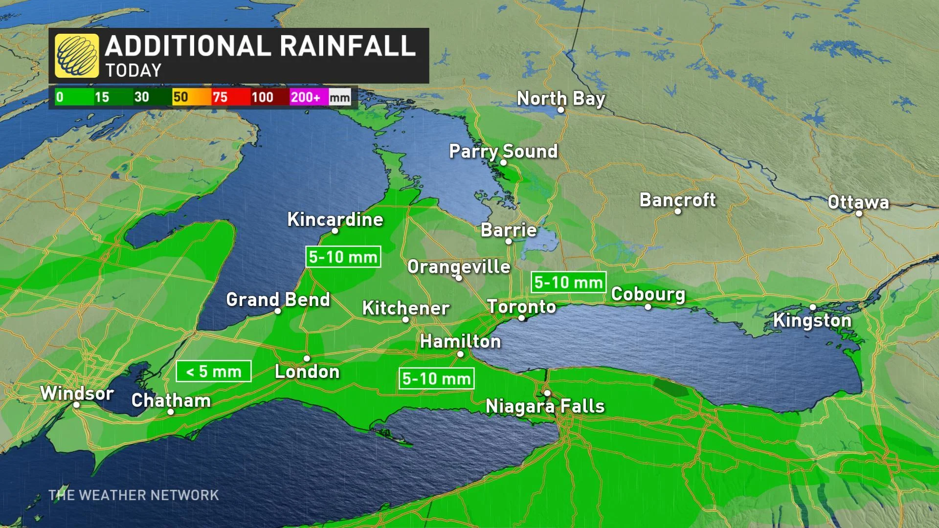
The Toronto and Region Conservation Authority (TRCA) has released a flood outlook alert, due to the warming temperatures and significant amount of ice that are covering rivers and streams. The TRCA advises that caution should be taken around all bodies of water as all rivers within the GTA may experience higher flows and water levels, which carries the potential to create flooding and hazardous conditions.
Vacation or staycation? See what Ontarians can expect from March Break weather.
STRONG WIND GUSTS TARGET THE REGION
Powerful winds will also be a concern through Sunday afternoon, with widespread gusts in the 60-80 km/h range, and locally 90+ km/h along the shores of Lake Erie, Lake Huron and Georgian Bay.
WATCH BELOW: TIMING OF POWERFUL WINDS
Wind gusts of this strength have the potential to produce minor tree damage, such as broken branches, and isolated power outages.
MILDER PATTERN DOMINATES NEXT WEEK
While a quick shot of colder weather follows in the wake of the system, a gradual warming trend is expected to take hold through much of next week. Highs several degrees above seasonal are expected for most and, and temperatures well above that move in by late week in the south.
With that said, winter seems determined to hold on to the bitter end for much of Canada, and Ontario is no exception. "We expect a substantial interruption to the milder pattern for the eastern half of Canada," according to The Weather Network's Dr. Doug Gillham.
It seems as though eastern Canada will have to wait a few weeks longer for the spring warmth to really take hold, but it's not all doom and gloom. "Note, this will still be much milder than how we started the month, but much colder than what we expected for this time period," says Gillham.