
Atlantic: Treacherous travel with intense winter-like storm

Back-to-back storms will once again target Atlantic Canada right through the weekend, with the first being a major Colorado low that threatens snow on areas that have managed to mostly escape it so far this fall season. Blustery northwest winds behind the system will also usher in brisk wind chill values and onshore snow for the start of the weekend, with forecasters closely watching the additional storms that bring more wintry weather to the region through next week. We take at the timing of this stormy and wintry set-up, below.
Visit our Complete Guide to Winter 2019/2020 for an in depth look at the Winter Forecast, tips to plan for it and a sneak peek at the spring season next year
WEATHER HIGHLIGHTS:
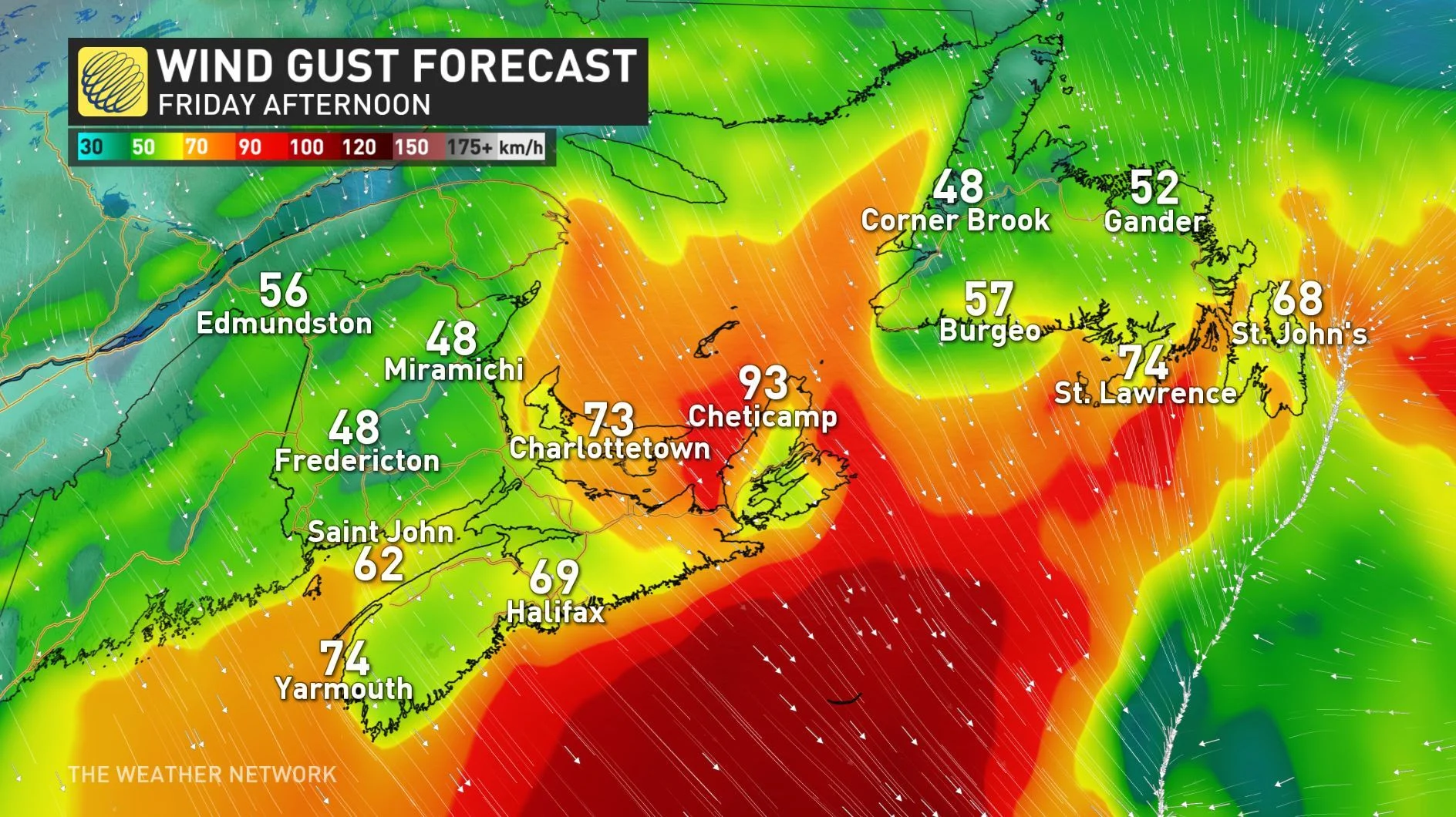
Strong northwest winds will mean brisk weekend wind chills for many by Friday
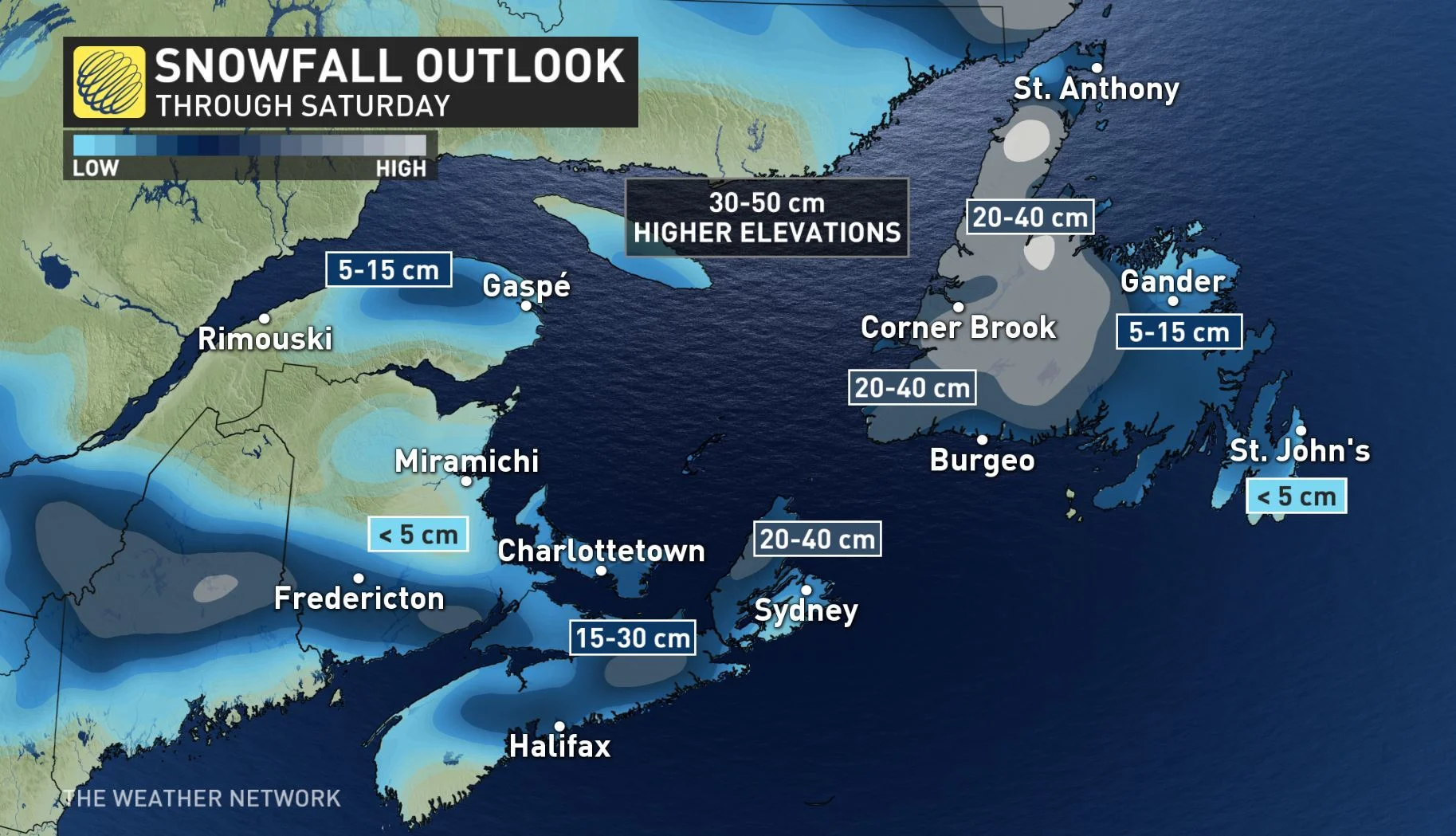
Snow pushes into central and western sections of Newfoundland Friday and Saturday, with enhancement from sea-effect snow through Sunday
Stay aware of ALERTS in your area
WATCH BELOW: TIMING OF RAIN AND SNOW
Northern Nova Scotia, PEI, and western Newfoundland will see snow squalls into Saturday morning due to a cold northerly flow, which will significantly reduce visibility that could be near-zero at times. The flurries can be heavy at times and the snow has the potential to accumulate quickly with some localized areas seeing up to 20 cm by Saturday morning.
Snow is expected to impact New Brunswick with some mixing inland expected for areas of southern Nova Scotia. The messy rain, snow mix forced some schools to close in New Brunswick early Thursday, with officials warning of dangerous travel for western sections of the province.
The heaviest snow is expected for areas north of the Bay of Fundy, but parts of Nova Scotia could be seeing at least some accumulation of wet snow by the time it all tapers.
Between 5-10 cm is expected through the day, with locally higher amounts possible over higher terrain.
Cold air wrapping around behind the system will also spread snow across much of Newfoundland on Friday.
CHILLY WINDS AND SIGNIFICANT SEA-EFFECT SNOW
Some of the coldest temperatures we've seen yet this season will flood into the region by the weekend, courtesy of some powerful northwest winds. Sea-effect snow will also impact PEI, much of Nova Scotia and eastern New Brunswick with 20-40 cm of snow expected by Saturday.
Along with northerly wind gusts well over 100 km/h along Cape Breton and the Gulf shores, travel will be severely impacted Friday and Saturday for the region.
The northerly flow will also bring sea-enhanced snow to much of Newfoundland as the low continues to impact the island through Saturday. Parts of western Newfoundland could see total accumulations of 20-30 cm, with localized amounts up to 40 cm possible.
Forecasters are also watching the potential for yet another significant and messy system early next week, which could be a winter storm for a large part of the region.
"This storm will track very slowly into Atlantic Canada next week and could stall for a while off the coast of New England. This will eventually bring a couple rounds of messy and wintry weather to the Maritimes with mostly rain to the south, but significant snow north of the Bay of Fundy," says Weather Network meteorologist Dr. Doug Gillham.
Stay with us here at The Weather Network for all your latest forecast updates.


