Hefty snowfall totals in parts of Alberta will make for hazardous travel
Chilly and snowy conditions will be infiltrating Alberta this week as we close out the month, and will likely make for tricky travel as roads will be slippery
Springtime snow is not uncommon on the Prairies, so this week's event should come as no surprise to Albertans.
What will be partly responsible for this week's snow will be an upper trough swinging in from the Gulf of Alaska.
DON'T MISS: How the tropics help produce big springtime snows on the Prairies
While the heaviest snowfall amounts are expected for regions along the foothills and into the mountains, with 20-40 cm possible, Calgary could end up with 5-10+ cm by the time the system departs Wednesday evening.
Environment and Climate Change Canada (ECCC) issued special weather statements along the foothills and snowfall warnings in the mountains.
Prepare for quickly changing and deteriorating travel conditions. Visibility may be suddenly reduced at times in heavy snow. Take frequent breaks and avoid strain when clearing snow.
Tuesday morning: Snowfall pushes in, travel conditions will worsen
A deepening low-pressure system adjacent to the Alberta-Saskatchewan border will drop wraparound, wet snow to parts of the former for a short time come Tuesday morning.
Snowfall will fall in Edmonton and areas west, extending to along the QE2, south of Calgary and stretching into the southern foothills.

Heavy snowfall rates are possible near Claresholm, Alta., so be prepared for changing weather conditions.
Tuesday night to Wednesday: Highest chance of accumulations for Calgary
The centre of low pressure will remain stalled across Saskatchewan, locking in the chilly north flow over Alberta. This will enhance the risk for localized heavy, wet snow around central and southern portions of the foothills.

Accumulations away from the foothills will remain fairly limited, regions along them and into the mountains could see between 20-40 cm of snow.
As a result, the greatest threat for accumulating snowfall in the Calgary area develops Tuesday night as cold air wraps in behind the low.
CANADA'S WILDFIRES: Visit The Weather Network's wildfire hub to keep up with the latest on the active start to wildfire season across Canada
Calgary could see 5-10+cm of snowfall before a period of rainfall pushes in later on Wednesday. Locally heavier totals are possible for higher elevations.

Combined with heavy precipitation rates, it’s likely that Red Deer and Calgary will experience bursts of wet snowfall through Wednesday morning.
By Wednesday morning, snow heavy at times could fall along the QE2, affecting Red Deer, Calgary and areas south to the U.S. border.
Come the evening time, the snowfall threat will have diminished across Alberta with the stubborn departure of the low-pressure system.

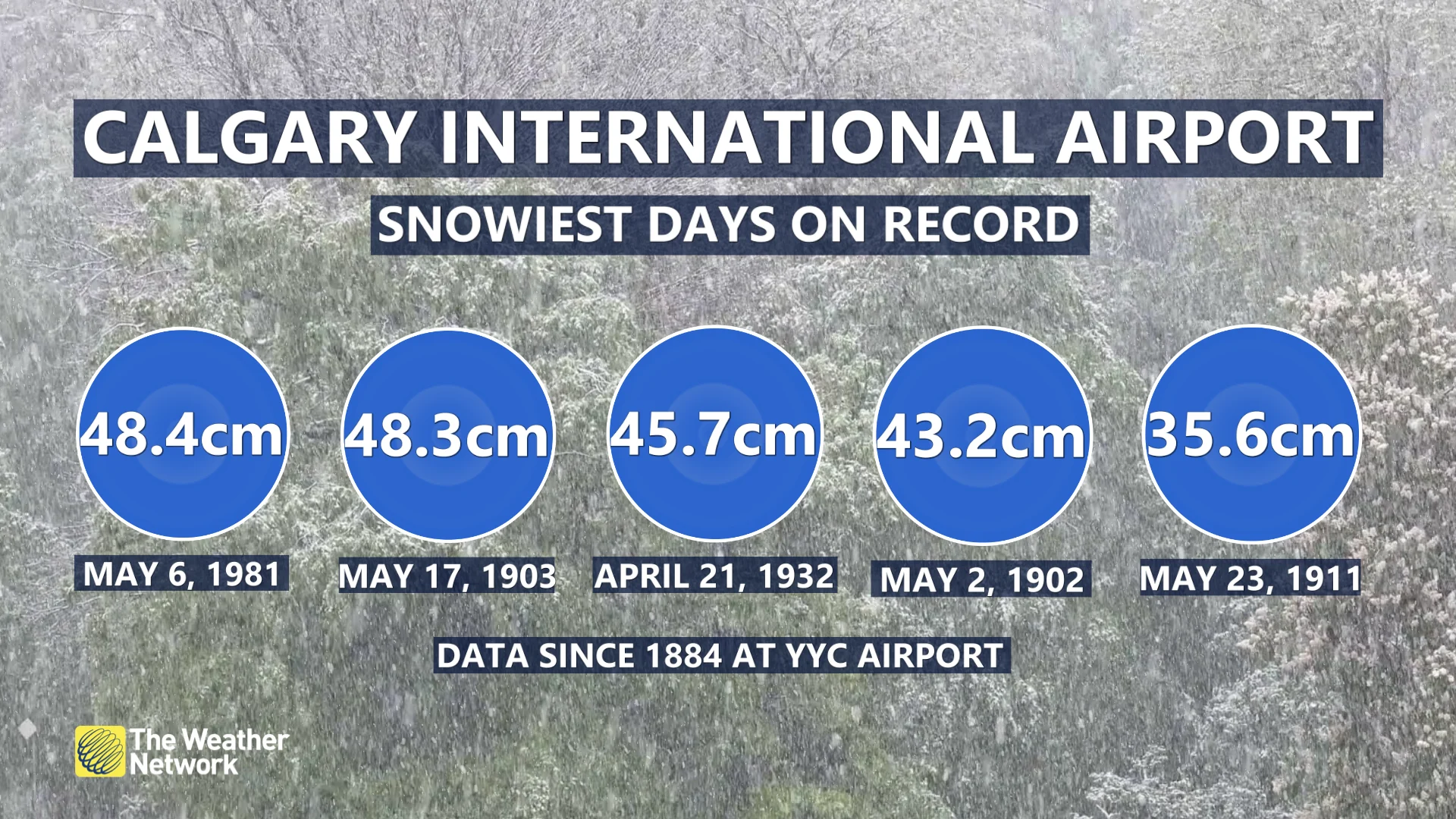
For folks annoyed at this springtime snowfall, it's important to remember that snow in April and May are normal for the province and that they are actually some of the snowiest months.
In fact, the top five largest snowfalls in Calgary took place in April and May.
MUST SEE: Bear-tracking study celebrates citizen science in Alberta's grizzly country
Be sure to check back for the latest weather updates across Alberta.